Interstate 295 (Maryland–District of Columbia)
| |||||||
|---|---|---|---|---|---|---|---|
| Anacostia Freeway | |||||||
_map.svg.png) | |||||||
| Route information | |||||||
| Auxiliary route of I‑95 | |||||||
| Length: |
8.05 mi[1] (12.96 km) 0.80 miles (1.29 km) in Maryland 7.25 miles (11.67 km) in the District of Columbia | ||||||
| Existed: | 1964 – present | ||||||
| Major junctions | |||||||
| South end: |
| ||||||
| North end: |
| ||||||
| Location | |||||||
| States: | Maryland, District of Columbia | ||||||
| Counties: |
MD: Prince George's DC: City of Washington | ||||||
| Highway system | |||||||
| |||||||

Interstate 295 (I-295) in the U.S. state of Maryland and in Washington, D.C. is a 8.05-mile (12.96 km) spur route connecting I-95 / I-495 and Maryland Route 210 (Indian Head Highway) near the Potomac River (just outside the District's boundary with Maryland) to Interstate 695 & D.C. Route 295 in the Anacostia neighborhood of Washington, DC.
Route description
Although I-295 technically begins at the Capital Beltway (I-95/I-495), a pair of mainline ramps connects the southern terminus of the route to the nearby MD 210. Continuing north from this interchange, I-295 enters the District of Columbia; the route is only 0.8 miles (1.3 km) long in Maryland. The highway is known as the Anacostia Freeway.
Passing to the west and north of Oxon Cove Park, the route parallels the Potomac River, running through the Southeast quadrant of D.C. It passes close to Shepard Parkway and forms the eastern boundary of Bolling Air Force Base and the Anacostia Naval Station. Near the southern end of Anacostia Park the route turns east and begins to parallel the Anacostia River, interchanging with South Capitol Street near the latter's crossing of the river.
_at_Exit_2_(Interstate_295_North%2C_Washington%2C_National_Harbor)_in_Oxon_Hill%2C_Prince_Georges_County%2C_Maryland.jpg)
Within the park, I-295 encounters the junction with I-695 (which heads northwest across the 11th Street Bridges) and D.C. Route 295 at Exit 4. At this junction I-295 ends and the mainline freeway through the interchange assumes the identity of D.C. Route 295 and continues to Baltimore, though it changes identities several times: DC 295, MD 201, the Baltimore-Washington Parkway (an unnumbered federally owned expressway operated by the National Park Service), and MD 295.
History
The Anacostia Freeway was first conceived by the National Capital Park and Planning Commission in 1950 as a connector route between the Baltimore-Washington Parkway at Kenilworth Avenue and the Capital Beltway near Oxon Hill. The route would provide access to the Anacostia waterfront, which included Bolling Air Force Base and the Anacostia Naval Station. In 1955, District officials approved the portion of the route between Suitland Parkway and E Capitol Street; the remainder of the route was approved in 1956. The southern portion of the route, from the Beltway to the 11th Street Bridges, was given a financial boost when it was included in the Interstate Highway System. The route was designated I-295 by AASHO in 1958.
_at_Exit_5_(Interstate_695_to_Interstate_395%2C_Downtown%2C_District_of_Columbia_Route_295_NORTH_to_U.S._Route_50%2C_11th_Street_SE%2C_MLK_Jr_Avenue)_in_Washington%2C_D.C..jpg)
The first 7.8 miles (12.6 km) of the route opened on August 7, 1964 when the connecting segment of the Capital Beltway opened. In 1990, the freeway was extended 1.7 miles (2.7 km) south to connect with MD 210, to remove the significant traffic flow between the two routes from the segment of the Beltway between both interchanges.
East Leg
Under the 1971 D.C. freeway plans, I-295 would have turned east at the northern end of the 11th Street Bridges and followed the Southeast Freeway as far as East Capitol Street, where it would turn north and follow the East Leg of the Inner Loop freeway. The East Leg, six lanes wide, would have curved around the far eastern edge of the downtown area, passing beneath Mt. Olivet Road in a 1/2 mile tunnel, before terminating at I-66 and I-95 north of Union Station, providing access to the North Leg Freeway, the North Central Freeway, and the New York Avenue Industrial Freeway.
Reconstruction of the southern terminus
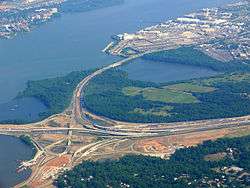
As part of the larger Woodrow Wilson Memorial Bridge reconstruction project, the southern terminus of I-295 has been significantly rebuilt. Several new connections have been constructed to link the Beltway, MD 210 and I-295 with the new 300-acre (1.2 km2) National Harbor site on the shore of the Potomac River in Prince George's County, Maryland. One feature of the interchange reconstruction is that accommodations were made for future ramps to proposed high-occupancy vehicle lanes (HOV) on the Beltway. This project was completed in stages starting in 2008 and ending in 2011.
Reconstruction of the northern terminus
The cancellation of both the remainder of the Southeast Freeway and then the Barney Circle Freeway left no through connections between the 11th Street Bridges and DC 295 north, leading to severe congestion and major traffic routing problems. These missing movements were included when the northern terminus was reconstructed, allowing direct freeway-grade access to and from DC 295 at the 11th Street bridges as well as providing a through grade-separated north–south route within D.C. Project construction began in 2011 and the ramps opened in 2012. I-295 now terminates at the interchange with the 11th Street Bridges. I-695 extends over the 11th Street Bridges and continues along the Southeast Freeway to the interchange with I-395.
Future
The District of Columbia is considering adding reversible HOV lanes to I-295.[2]
Exit list
| State | County | Location | mi[3] | km | Exit | Destinations | Notes |
|---|---|---|---|---|---|---|---|
| Maryland | Prince George's | Oxon Hill | 0.00 | 0.00 | – | Continuation beyond I-495 | |
| 0.00 | 0.00 | 1 | Signed as exits 1A (north), 1B (Harbor), and 1C (south) | ||||
| 0.80 0.00 | 1.29 0.00 | Maryland-DC border | |||||
| District of Columbia | Washington | 1 | Laboratory Road – Naval Research Lab, Blue Plains Plant | ||||
| 2 | South Capitol Street / Malcolm X Avenue SE – Bolling AFB | ||||||
| 3A | Suitland Parkway – U.S. Naval Station, Andrews AFB | No access from Suitland Parkway north to I-295 south | |||||
| 3B | South Capitol Street / Howard Road SE – Nationals Park, Downtown | ||||||
| 7.25 | 11.67 | 4A | Southern terminus of DC 295 | ||||
| 7.25 | 11.67 | 4B | 11th Street SE / MLK Jr. Avenue SE | Opened in 2014 as part of 11th Street Bridges reconstruction | |||
| 7.25 | 11.67 | – | Rebuilt in 2014 as part of 11th Street Bridges reconstruction | ||||
| 1.000 mi = 1.609 km; 1.000 km = 0.621 mi | |||||||
See also
-
 U.S. Roads portal
 -
 Maryland Roads portal
 -
 Washington, D.C. portal
References
- ↑ "Route Log - Auxiliary Routes of the Eisenhower National System Of Interstate and Defense Highways - Table 2". Federal Highway Administration. Retrieved 5 October 2014.
- ↑ "Plans for HOT lanes on 14th Street Bridge and D.C. freeways still just warming up". The Washington Post. April 19, 2014.
- ↑ Highway Information Services Division (December 31, 2013). Highway Location Reference. Maryland State Highway Administration. Retrieved 2012-09-09.
- Prince George's County (PDF)
External links
| Wikimedia Commons has media related to Interstate 295 (District of Columbia). |
- I-295 @ MDRoads.com
- I-295 on Kurumi.com
- Steve Anderson's DCroads.net: Anacostia Freeway (I-295 and DC 295)
- Roads to the Future: Washington D.C. Interstates and Freeways
| ||
