Ingiriya
| Ingiriya ඉංගිරිය இங்கிரிய | |
|---|---|
|
Ingiriya Town view from the top of a Mountain | |
 Ingiriya Location Map | |
 Ingiriya Ingiriya Location Map | |
| Coordinates: 6°44′38″N 80°10′20″E / 6.74389°N 80.17222°ECoordinates: 6°44′38″N 80°10′20″E / 6.74389°N 80.17222°E | |
| Country | Sri Lanka |
| Province | Western Province |
| District | Kalutara District |
| Government | |
| • Electoral Division | Horana Polling Division |
| • Local Government | Horana Pradeshiya Sabha |
| • Divisional Secretariat | Ingiriya Divisional Secretariat |
| Elevation | 137 m (449 ft) |
| Population (2015) | |
| • Total | 55,133 |
| • Density | 252.66/km2 (654.4/sq mi) |
| Time zone | SLT (UTC+05:30) |
| Postal Code | 12440 |
| Telephone code | 0094-3422 XXXXX |
| Website | www.ingiriya.info |

Ingiriya (ඉංගිරිය) (இங்கிரிய) is a town in Kalutara District of Western Province . It is situated near the border of Western Province and Sabaragamuwa Province and it is a junction which connects Rathnapura-Panadura Road,Ingiriya-Padukka Road and Ingiriya-Bulathsinhala Roads. All the Nationalities representing Sinhalese 89.5%, Tamils 9.5%, and others 1% live in the town. In 2001, the city Ingiriya had a population of 45,726, and in 2015, it has increased to 55,133. The area is approximately 9204 hectares. There are about 15,240 families living here. This consisted of Buddhist 89.4%, Hindus 10%, Christians 1.6% and others 0.1%.[1]
Location
Ingiriya can be accessed via the A8 (Rathnapura – Panadura) highway (33 km from Panadura, 35.8 km from Rathnapura), by Padukka – Ingiriya Road (16.80 km from Padukka, 18.20 km from Meepe) or by the Egaloya - Ingiriya Road (11 km from Egaloya). Ingiriya is one of the borders of Kalutara District and Western Province. Ella, the next town after Ingiriya towards Rathnapura side, belongs to Ratnapura District, Sabaragamuwa Province and Padukka, the next town after Ingiriya towards Padukka side, belongs to Colombo District.
Diistance from Ingiriya to Nearby Towns
- Horana-13.50 km
- Padukka-16.80 km
- Meepe-18.20 km
- Idangoda-18 km
- Panadura-33 km
- Rathnapura-35.80 km
- Avissawella-43 km
- Colombo-51 km
- Egaloya-11 km


Geography
The Ingiriya city spreads starting, 24 km from the sea side of the country to 8.8 km to the inner side of the country. Basically, the area is full of lonely mountains and the east border contains more mountain characteristics. The highest land of the area is Madakada Giranchi Mountain with 1165 feet height. The Eduragala Mountain is also over 700 feet in height. The eastern part contains some higher mountains over 500 feet here and there and also in western part there are same kind of mountains. But the 60% of the whole land is plain. The Kalu river flows along the southern border of Ingiriya and many streams flow from various places of the zone to Kalu River. From the eastern part it flows Nambapana stream and the largest stream of the area, Mawak Oya starts from North and flows along west side and connects to the Kalu river in the South.


| Land Use | Area (km2.) | Percentage % |
|---|---|---|
| Home Garden | 2293 | 25% |
| Tea Plantation | 582.81 | 06% |
| Rubber Plantation | 3067.49 | 33% |
| Coconut Plantation | 348.97 | 04% |
| Paddy Plantation | 1132.32 | 12% |
| Other Plantations | 278.78 | 03% |
| Forest | 801.64 | 09% |
| Scrub | 157.38 | 02% |
| Water Bodies | 123.88 | 01% |
| Other Land | 416.84 | 5% |
| Total | 9204 | 100% |
Climate
Ingiriya belongs to the Low Country Wet Zone. The climate is very medium. The area gets a 3500mm-4500mm rainfall. The annual rainfall rate is 4200mm. As this area is in wet zone low lands, it gets rain from both East west Monsoon and South west Monsoon as shown below. .

- Inter Monsoonal Period = March - April
- South West Monsoonal Period = In the middle of May - In the middle of September
- Inter Monsoonal Period = September - October
- East West Monsoonal Period = In the middle of November - January

| Month | Annual Rainfall in mm | Monthly Rainfall in Days | Temperature in C' |
|---|---|---|---|
| January | 96 | 03 | 27.2 |
| February | 487 | 11 | 27.8 |
| March | 275 | 10 | 28.3 |
| April | 465 | 19 | 28.3 |
| May | 152 | 10 | 27.9 |
| June | 323 | 23 | 27.3 |
| July | 158 | 07 | 27.1 |
| August | 386 | 18 | 27.1 |
| September | 381 | 16 | 27.0 |
| October | 914 | 19 | 27.1 |
| November | 470 | 10 | 27.1 |
| December | 482 | 15 | 27.1 |
| Annual | 4589 | 161 | 27.5 |
Natural Disasters
Ingiriya city faces only one natural disaster from time to time – flooding. The Kalu River which flows along southern border overflows and Nambapana, Eastern and Western Urugala, Western Ingiriya town, Wagawatta, Kekulaliya, Western Poruwadanda and Dombagaskanda areas are affected by the flood.


Agriculture
Ingiriya belongs to the Low Country Wet Agricultural Zone. The annual rainfall rate is about 4200 mm and the annual temperature is from 29−75° Celsius. Ingiriya gets rainfall from both Southwest monsoon and East–West monsoon. So the land and climate is very suitable for cultivation. All the main cash crops, tea, rubber, coconut and paddy are grown in Ingiriya.
As of 2009 reports there are 5039 acres of rubber plantation, 1569 acres of tea plantation, 1500 acres of coconut plantation and 22 acres of land cultivated with paddy.


Administration


The Ingiriya city, which is administered by the Horana Pradeshiya Sabha (Divisional Council) is a part of the Horana Polling Division. Notable government institutions in Ingiriya include:
- Ingiriya Divisional Secretariat
- Ingiriya Police Station
- Ingiriya District Hospital
- Ingiriya Medical Officer of Health
- Ingiriya Post Office
- Ingiriya Co-operative Services
Ingiriya Divisional Secretariat office is the main administration institute under which Ingiriya City is ruled. Ingiriya was a part of the Horana Divisional Secretariat earlier. In August 14 of year 2000, 31 Grama Niladhari divisions were divided and they were assigned to Ingiriya Divisional Secretariat. This change occurred due to the large size of Horana division and the increment of the population.
The government health services of Ingiriya are supplied by Ingiriya Medical Officer of Health office and by Ingiriya District Hospital. The prevention process is done by the Ingiriya Medical Officer of Health office and by treatments are done by the Ingiriya District Hospital.
The Medical Officer of Health (MOH) office is the main preventive medical center for public health activities in the region, situated at Horana Road in Ingiriya town.
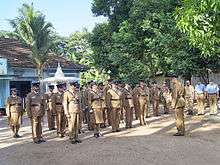
The Ingiriya Police Station, which was started in 1948, plays the major role in security.
The Main Post Office is situated in the Ingiriya town which is an A grade Post Office. Other Sub Post Offices are situated in surrounding areas.
There is a Fuel Station in the town which is run by Ingiriya Co-Operative Office and another 2 private fuel stations at Handapangoda and Eduragala.


Transportation
Ingiriya city is located along Panadura and Rathnapura A8 Road. The Padukka-Ingiriya Road connects the A8 road at Ingiriya Junction. There is an unfamous road heading Ingiriya from Egaloya of Bulathsinhala–Horana Road. There are 3 ways to visit Ingiriya. They are, the Rathnapura-Panadura Road, Ingiriya road which starts at Padukka and Hanwella and the Egaloya-Ingiriya Road.
There are two Bus Stands in Ingiriya city. All the buses which travel along A8 road parks at the new bus stand along A8 road. All other buses park at the old bus stand along Ingiriya-Padukka Road.
Buses Start from Ingiriya
- 449 - Horana-Ingiriya
- 285 - Bulathsinhala-Ingiriya (via Egaloya)
- 125 - Maharagama-Ingiriya
- 125 - Colombo-Ingiriya (via Godagama)
- 686 - Keenagahawela-Ingiriya (Nachchmale Area)
- 885 - Dumbara-Ingiriya
- 491 - Rathnapura-Ingiriya
- 885 - Gawaragiriya-Ingiriya
- 1/288 - Epitawaththa-Ingiriya (via Halwathura)
- 2/282 - Padukka-Ingiriya (via Yatawathura,Panangala,Maputugala)
- - Mathale-Ingiriya
Buses travel across Ingiriya
- 450 - Rathnapura-Panadura
- 449 - Karandana-Horana
- 064 - Panadura-Mahiyanganaya
- 064 - Panadura-Badulla
- 64/98 - Panadura-Ampara
- 64 - Aluthgama-Balangoda
- 457 - Ambilipitiya-Sooriyawewa
- 120 - Kalawana-Colombo
- 473 - Kalawana-Horana
- 190 - Bulathsinhala-Colombo (via Battaramulla)
Natural Beauty

Following places are the famous places where many visitors pay their attention.
- Nachchimale Bathing Port - Ingiriya
- Madakada Aranya Senasanaya - Ingiriya
- Parei Thota Bathing Port - Nambapana
- Bodhinagala Aranya Senasanaya - Eduragala
- Bodhinagala Bird Sanctuary - Eduragala
- Hora Forest Reservation - Kirigala
- Kuran Oya Waterfall - Kurana
- Urugala Holombuwa - Urugala East

Nachchimale
Nachchimale (නාච්චිමලේ) is the most famous area of Ingiriya. It is reached by traveling about 1 mile towards Padukka from Ingiriya town. You must turn left to the Keenagahawila road from Maha Ingiriya Junction. After travelling about 1 and half miles towards that road, you will reach there after passing the Madakada Aranya Senasana Road. The Nachchimale port is a part of the Nambapana Lake. Beautiful waterfalls, stone holes filled with clear water are a common scene. Thousands of foreigners and local visitors come to visit Nachchimale to bathe and have fun. Tourism brings both good and bad to the area. This area contains the most environmental pollution of Ingiriya. As the visitor numbers increase, the harm done to the natural environment has also increased day by day. It is a common scene that there are lots of bottles and polythene strewn about. This has been a major problem to the environment and the residents. From time to time many organizations including Ingiriya Police Station do shramadana programs to clean this area.
Madakada Aranya Senasanaya
It is reached by traveling about 1 mile towards Padukka from Ingiriya town. You must turn left to the Keenagahawila road from Maha Ingiriya Junction. After traveling about 1 and half miles towards that road, you will reach there. The history of this monastery goes back to 1940 and there were over 100 meditative monks living here at that time. The new monastery was built by Rev. Ranwala Saddhatissa thero in 1948. In ancient times this area was a forest area with caves and then after arrival of the Saddahtissa thero for his meditations, this area became a forest monastery.
Madakada Aranya is one of the premier “Vipassana” meditation centers in the country. It also has branches in places such as Navinna, Salgala and few other places in the country. Contributions of this center for religious well-being of Sri Lankans as well as for foreigners are invaluable. Presently there are about 16 resident bhanthes and 7 resident laymen practicing “Vipassana” meditation at any given time. As it is a local Buddhist way of life they have been well looked after by devotees in their day-to-day needs.

The main cave has many Buddha statues, paintings and is decorated with flowers. There are about 12–15 meditation caves here. In this Aranya Senasana there are about 15–20 meditative monks residing. This place is situated in a Natural Forest Reservation and a stream called Nachchimale flows through one boundary of the monastery adding additional scenic beauty to the area. The visitors who come to bathe here do not forget to visit the monastery. The surroundings of this place are very calm and there are many local inheritable plants, herbal plants, birds, rare butterfly species, and wild animals in this beautiful environment.
Parei Thota
Parevi Thota (පරෙවිතොට) or Parethota (පරේතොට) is a very famous area in Ingiriya. When traveling towards Rathnapura road from Ingiriya town about 1 mile, you have to turn left to the Nambapana School Road. After traveling about half a mile passing the school you can reach this place. This place is very rich in natural beauty and it is a huge port in the Nambapana stream, which is a part of the Kalu River. As the surrounding environment is very beautiful, the number of visitors coming to bathe in this place is very high. The small ports and waterfalls in the small stream situated near Parethota area adds a nice beauty to this place.
The Environmental Pollution done to this wonderful environment by the thousands of visitors who visit Parethota area to bathe and have fun is not small. They put polythene and bottles everywhere which has become a dangerous threat to the natural environment. Because of this reason the residents and the visitors face many difficulties. So, if you visit there, please leave only the footprints.

Bodhinagala Aranya Senasanaya
Bodhinagala Aranya Senasanaya can be reached by traveling about 3 miles from Ingiriya town and have to turn left from bodhinagalaa road. After traveling about one and half miles you will reach this place. The Dombagaskanda Forest Reservation where this place is situated was named in 1955. This beautiful place is on a claim and natural environment. In South East of this beautiful forest area, flows the Kalu River and that slope area is rich in herbal plants and southern wet zone plants inheritable to this area. There are about 20-25 monks meditating in the caves situated here and there in this Aranya Senasana. The meditative monks come out from the caves only when they eat and then they go back to the caves in the forest. This area is very calm and high in security. Many foreigners and local visitors come to visit this Aranya Senasana.
Bodhinagala Bird Sanctuary
This is a secondary lowland rain forest patch in the area of Ingiriya. The entrance to this precious place can be reached by traveling about 3 miles from Ingiriya town and by turning left to Bodhinagala road from Bodhinagala Junction. After traveling couple of miles you have to turn left and you will reach this forest reservation after traveling towards that road. One of the famous “Aranya senasanaya” in the area is here. To find this place is not a difficult task and the direction sign boards are also have being established along the road. The forest reserve consists of two mountains which are surrounded by the villages. Inside the forest there are concreted routes created in favor of the Buddhists monks lived here for the meditations. It seems that the forest is being disturbed by the people who visits the place, even though there are separated visiting hours for them.

Hora Forest Reservation
Situated at Kirigala area. When traveling towards Handapangoda from Ingiriya town about 6miles you can reach this environmental sensitive area. It is said that this Hora Reservation owns the largest number of Hora trees in South Asia. It is a very beautiful place. Apart from that, it has many rare plants also in this reservation.
Kura Uda Waterfall
When traveling 3 miles from Ingiriya town towards Handapangoda you must turn right from the Kotigala junction and will meet this place about one and half miles. This waterfall is situated in the middle area of the small stream starting from Giranchi Mountain in the Forest Reservation. Though this place was not so famous in the past, recently the amount of visitors has been increasing. The Government Forest Reservation which this waterfall is situated is rich in rare wet zone plants and herbal plants. Many birds and animals inheritable to this area lives here.
Urugala Holombuwa
After the arrival of British a new road system was established under their reign.In ancient time there were no good roads in Sri Lanka. In this time goods were transported to coastal areas from Sabaragamuwa area by rivers. Kalu River was a major river in this transportation. This 'Holombuwa' is situated near Ingiriya area of the Kalu River.
After traveling about 2 miles towards Rathnapura road from Ingiriya town you can reach this place. This place was used as an anchoring point for vessels and ferrys transporting goods. This holombuwa is the biggest whirlpool of the place where Nambapana Stream connects with Kalu River. This place has more space and consists of a huge rock pile. Because of this characteristic, the boatsmen used this place as a resting place.


History
Ingiriya can be described as an area consisted with beautiful water bodies, mountain ranges, plain lands and other attractive physical features. One of the four main rivers, the Kalu River flows from Sabaragamuwa Province to Kalutara passing Ingiriya. As the boundary (Ima) of the Sabaragamuwa Mountain ranges end at Ingiriya, it is said in the folklores that “Imagira” became Ingiriya later. The main town of the area Ingiriya can be denoted as a city which was born in the beginning of Plantation Colonization of the British Rulers. The Urugala and Nambapana areas of Ingiriya have a history which relates to the Kings who ruled near Kalu River.

A Beautiful Environment is owned by Ingiriya which have a great historical value. This Area contain many Temples and Aranya Senasanas. As a small amount of population of Hindu religion, Tamil people live in the Plantation Estates there are some Hindu Kowils to worship their Religion and there is a Christian church also situated in Ingiriya. This shows that there are people of different Nationalities and different Religions living in this area. They are very peaceful people who always expect the development of the area.
When we go through the History of Ingiriya, we can find that there were people living in this area for a long time as they are recorded in the historical writings. It can be clarified by an Income Report of Portuguese written in 1599 about the revenue they collected from nearby places like Munagama, Wagawatta, Kekuladola. The present road of Rathnapura – Panadura which runs through Poruwadanda has historical evidences of usage even before 186 years. A British Doctor named John Dave has travelled to Adams Peak in 1817 from Panadura via Horana, Rathnapura and Palabaddala. He has described the beauty of Ingiriya area as he travelled in this road and he has clearly stated it in his writings.
Schools
Ingiriya area contains 22 schools which are controlled by Provincial council as shown below.
| School | Medium | G.N Division | Active Grade |
|---|---|---|---|
| Ingiriya Gamini Madya Maha Vidyalaya | Sinhala/English | 620C,Ingiriya North | 1 AB |
| Ingiriya Sri Sumanajothi Primary School | Sinhala | 620C,Ingiriya North | 3 |
| Urugala Sri Darmaloka Maha Vidyalaya | Sinhala | 619,Urugala East | 2 |
| Nambapana Kanishta Vidyalaya | Sinhala | 619A,Nambapana | 2 |
| Raigamwaththa Parakkramabahu Primary School | Sinhala | 620B,Raigamwatta | 3 |
| Kakulaliya Primary School | Sinhala | 618B,Kekulaliya | 3 |
| Handapangoda Maha Vidyalaya | Sinhala | 623B,Handapangoda West | 1 C |
| Sagara Palansuriya Maha Vidyalaya | Sinhala | 622,Handapangoda South | 1 C |
| Isipathana Kanishta Vidyalaya | Sinhala | 625,Arakawila | 2 |
| Maputugala Maha Vidyalaya | Sinhala | 621A,Rathmalgoda | 1 C |
| Menerigama Primary School | Sinhala | 625A,Menerigama | 3 |
| Batugampala Primary School | Sinhala | 624,Batugampala | 3 |
| Kalupahana Kanishta Vidyalaya | Sinhala | 618,Wagawatta | 2 |
| Manana Sri Ghanarathana Primary School | Sinhala | 620F,Dombagaskanda | 2 |
| Pelpitigoda Primary School | Sinhala | 622,Pelpitigoda | 3 |
| Kandanapitiya Primary School | Sinhala | 626,Kandanapitiya | 3 |
| Kurana Primary School | Sinhala | 627,Kurana South | 3 |
| Dharmaloka Primary School | Sinhala | 623B,Handapangoda West | 3 |
| Eduragala Tamil Primary School | Tamil | 620E,Eduragala | 3 |
| Raigamwaththa Tamil School | Tamil | 620B,Raigamwaththa | 2 |
| Raigamwaththa Saraswathi Tamil School | Tamil | 620G,Raigamwaththa | 3 |
| Perth Tamil School | Tamil | 618,Wagawatta | 3 |
 Gamini School
 Sumanajothi School
 Dharmaloka School
 Saraswathi Tamil School
Religious Places

There are many places of worship in and around the city. Buddhist places of worship are more in number, which is to be expected since Buddhists constitute the great majority in the area. Nevertheless, there are few places of worship in the town related to other religions also.


Temples
| Name | Address |
|---|---|
| Sri Devarakkitharamaya Temple | Wagawatta, Poruwadanda |
| Sri Sandagiri Temple | Arakawila, Handapangoda |
| Sri Wickramasinharamaya Temple | Maputugala, Poruwadanda |
| Sri Wijaya Bodhiraja Temple | Imagira, Ingiriya |
| Sri Thapodhanarama Temple | Pingodella, Urugala, Ingiriya |
| Sri Poorwarama Temple | Dombagaskanda, Ingiriya |
| Soliraja Temple | Ganethenna, Poruwadanda |
| Thilakaramaya Temple | Poruwadanda |
| Sri Sanghikaramaya Temple | Rathmalgoda, Poruwadanda |
| Ganeviharaya Temple | Handapangoda |
| Sri Sudharshanaramaya Temple | Manana, Poruwadanda |
| Sri Piyadassanaramaya Temple | Kurana, Kotigala, Handapangoda |
| Sri Sudharmaramaya Temple | Kekuladola, Batugampola |
| Sri Madurasama Temple | Nimalagama, Poruwadanda |
| Sri Gangathilaka Temple | Puhuwala |
| Sri Jayasooriya Temple | St.Peter’s Colony, Ingiriya |
| Sri Nandarathanaramaya Temple | Pelpitigoda, Poruwadanda |
| Deepaloka Temple | Ingiriya |
| Sri Poorwaramaya Temple | Kandanapitiya, Bope, Padukka |
| Siri Nikethanaramaya Temple | Kekulaliya, Poruwadanda |
| Sri Wijayasunandaramaya Temple | Panangala Watta, Poruwadanda |
| Sri Sambodhi Temple | Arunagama, Poruwadanda |
| Sri Ruwanbodhi Temple | Boralugoda, Poruwadanda |
| Sri Sudhampaya Temple | Bodhirajagama, Ingiriya |
| Sri Isipathanaramaya Temple | Madakada, Bope, Padukka |
| Madakada Aranya Senasanaya | Madakada, Ingiriya |
| Bodhinagala Aranya Senasanaya | Dombagaskanda, Ingiriya |
| Nagalena Wiwekaramaya Temple | 20 Acres, Ingiriya |
| Sri Jinarathanaramaya Temple | Arakawila, Handapangoda |
| Sri Shailatalaramaya Temple | Wagawatta, Poruwadanda |
| Kemanandaramaya | Batugampola |
| Sri Sambodhi Aranya Senasanaya | Madakada |
| Sri Subodhi Meheni Aramaya | Kurana |
Kowils
| Name | Address |
|---|---|
| Sri Muththumari Amman Kowil | Wagawatta, Poruwadanda |
| Sri Kurunchi Mahamari Amman Kowil | Raigamwatta, Ingiriya |
| Ingiriya Sri Paththini Kowil | Ingiriya |
| Raigamwatta Sri Paththini Kowil | Raigamwatta, Ingiriya |
Churches
| Name | Address |
|---|---|
| Ingiriya Church | Ingiriya |
Notes
References
- "Ingiriya Articles" (Article). Ingiriya.info.
- "Ingiriya News Bulletin" (Article). Ingiriya.info.
- "Ingiriya Photo Gallery" (Gallery). Ingiriya.info.
- "Ingiriya Schools" (Article). Ingiriya Divisional Secretariat.
External links
| Wikimedia Commons has media related to Ingiriya. |
- Official Website of Ingiriya
- Ingiriya Divisional Secretariat Web
- Unknownsrilanka Blog
- Gamini School Web
- Madakada Aranya Blog
- Srilanka-naturetrails Blog