Hurlstone Park, New South Wales
| Hurlstone Park Sydney, New South Wales | |||||||||||||
|---|---|---|---|---|---|---|---|---|---|---|---|---|---|
 Crinan Street, Hurlstone Park | |||||||||||||
| Population | 4,692 (2011 census)[1] | ||||||||||||
| Postcode(s) | 2193 | ||||||||||||
| Location | 9 km (6 mi) inner-west of Sydney CBD | ||||||||||||
| LGA(s) | |||||||||||||
| State electorate(s) | Canterbury | ||||||||||||
| Federal Division(s) | |||||||||||||
| |||||||||||||
Hurlstone Park is a suburb in the Inner West of Sydney, New South Wales, Australia. Hurlstone Park is located nine kilometres south-west of the Sydney central business district and is mostly in the local government area of the Canterbury-Bankstown Council, and partly in the Inner West Council. The suburb is bounded by: the Cooks River to the south, Garnet Street to the east, New Canterbury Road to the north, Canterbury Road to the north-west, and Church Street to the west.
History
Hurlstone Park was first known as 'Wattle Hill' and then 'Fernhill'. After the Postmaster-General's Department refused to open a post office called Fernhill, a 1910 referendum chose the name 'Hurlstone', after the nearby Hurlstone College. John Kinloch founded the college in 1878, on the site of present-day Trinity Grammar School and named it after his mother's maiden name, which was Helen Hurlstone. The college moved to a new site, now known as Hurlstone Agricultural High School. The 'Park' was added at the request of the Railways Department, to avoid confusion with the New South Wales town of Hillston.[2]
Transport
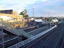
Hurlstone Park railway station is a Sydney Trains station (located 8.8 km from Central Station) on the Bankstown line. Sydney Buses provides the following services in Hurlstone Park: 444; 445; 428, and L28 routes which run along the Canterbury Road and New Canterbury Road boundary, and the 418 (to Burwood via Ashfield, and to Tempe via Dulwich Hill, Marrickville and Sydenham), and 406 (to Five Dock via Ashfield) routes which pass through the suburb (along Crinan Street with a bus stop directly outside the railway station).
Commercial area
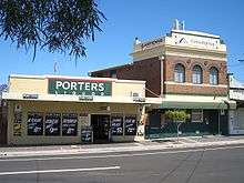
There is a group of shops around Hurlstone Park Station: along Crinan Street, the southern end of Duntroon Street and Floss Street. There are also commercial areas along Canterbury Road and New Canterbury Road.
The rest of the commercially used land in Hurlstone Park is made up of various shops, ranging from fast food outlets and milk bars to a couple of petrol stations. Hurlstone Park also has three childcare centres. Specific to Hurlstone Park village are the following businesses: two cafés, a seven-day supermarket, newsagent, gourmet butcher, lawyer, dry cleaner, laundry service, post office, doctor's surgery, dentist, shoe repair, bakery, real estate agent, naturopath, seven day bottle shop, convenience store, three hairdressers, an Asian grocery store and two ATM's (one CBA and one Citibank).
There is an active, local Chamber of Commerce: Canterbury-Hurlstone Park Chamber of Commerce.
Pubs and clubs
Hurlstone Park contains the following clubs and pubs:
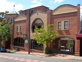
- The Canterbury Hurlstone Park RSL club, located on the corner of Canterbury Road and Crinan Street, is an entertainment venue that attracts many Australian and international performers. The club also contains a war memorial chapel.[3]
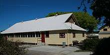
- The Hurlstone Park Bowling & Recreation Club. Located in Marcia street.
- The Hurlstone Park Hotel, located on the corner of New Canterbury road and Duntroon street, is also known as "Grumpy's".
- The Sydney Olympic Sporting Club was located at 64 Tennent parade. It was demolished in October 2010.
 Canterbury Hurlstone Park RSL Club
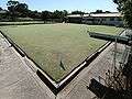 Bowling and Recreation Club
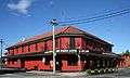 Hurlstone Park Hotel on New Canterbury Road
 The Sydney Olympic Sporting Club (now demolished)
Houses

Hurlstone Park is a predominantly residential suburb. The majority of the residential land in Hurlstone Park is single dwelling housing ie.detached houses. Only a small proportion of the residential land is multiple dwelling housing such as units or townhouses, though recent planning approvals indicate that this proportion is likely to grow.
Parks and reserves

Hurlstone Park includes the following parks and reserves:
- Ewen Park. Located along the Cooks river (in the middle of the southern end of the suburb). It is the largest individual park in the suburb and contains two playing fields that are home to the Hurlstone Park Wanderers[4] soccer club. The fields in Ewen park are also used for cricket in summer.
- Warwick Reserve. Located at the intersection of Church and Canberra streets in the south-west corner of the suburb.
- Euston Reserve. Located at the intersection of Euston and Floss streets, the reserve contains a war memorial.[5][6]
- Sawyer Reserve. Located at the intersection of Dunstaffenage street and Foord avenue.
- Hurlstone Memorial Reserve. A small reserve located next to the Hurlstone Park Bowling Club (along Crinan street).
- Burnett Street Reserve. The reserve splits Burnett street into two sections.
- Dick Poole Reserve. A small reserve that joins the end of Barre street with the point where Wallace avenue and Wallace lane meet.
- Moser Reserve. A small reserve on the south side of the railway line in Keir Avenue.
- Fernhill Street Reserve. A small reserve near the northern end of Fernhill street (with lane access to Barton avenue).
- Dunkeld Reserve. A small reserve near the western edge of the suburb (in Dunkeld avenue).
- A small reserve at the intersection of Garnet street and Tennent parade (in the south-east corner of the suburb). Located next to the 14th hole of Marrickville golf course, the unnamed reserve contains a cricket practice net and a practice goal post (for soccer and rugby).
- A small reserve on the corner of Crinan and Melford streets. The unnamed reserve is a small grassed area that was opened to the public following the demolition of a single house.
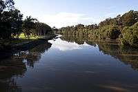
- A green belt along the entire southern border of the suburb. The belt follows the Cooks River and encompasses Ewen park. The Botany Bay cycle way[7] extends for 23 km (with Hurlstone Park being approximately one third of the way from Botany Bay to Ryde). The western part of the belt contains a constructed rectangular inlet of water named Boat Harbour. The eastern part of the belt constitutes part of the 13th and 14th holes of Marrickville Golf Course. There are three foot bridges that cross the Cooks River to the south of the belt: One bridge crosses from the end of Sugar House Road (off Hutton Street), a second bridge crosses from the end of Foord Avenue, and the third bridge crosses near the intersection of Tennent Parade and Burnett Street.
Churches and religion
According to the 2011 census, the top responses for religious affiliation in Hurlstone Park were Catholic 32.7%, No Religion 21.6%, Eastern Orthodox 13.0%, Anglican 7.8% and Buddhism 3.9%.[1]
The suburb contains the following religious establishments:
- St Stephen Greek Orthodox Archdiocese of Australia. Located at 650 New Canterbury road.
- Hurlstone Park Uniting Church (Dulwich Hill parish). Located at 8 Melford street, the church provides services in English and Tongan.
- Sydney Revival Fellowship Inc. Located at 83 Dunstaffenage St.
- Siddha Yoga Ashram. Located at 50 Garnet Street.[8]
- Hurlstone Park Vietnamese Baptist Church. Technically, the location of the church (corner of Queen and Griffiths streets) is in the neighbouring suburb of Ashfield (but only by 180 metres).
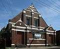 Hurlstone Park Uniting Church
 St Stephen Greek Orthodox Church
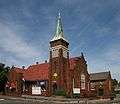 Hurlstone Park Vietnamese Baptist Church
Siddha_Yoga_Ashram_Hurlstone_Park_Sydney.jpg) Siddha Yoga Ashram, Garnet Street
Siddha Yoga Ashram, Garnet Street
Schools
Only one school is located in Hurlstone Park. The Edgeware School[9] is an alternative Department of Education facility, mainly for year 9 to 12 students who have been unsuccessful in mainstream schools. It is located in Burnett street (just off Tennent parade).
Population
At the 2011 census, there were 4,692 residents in Hurlstone Park. Almost half of people were born outside of Australia, with the top countries of birth being Greece 5.3%, Lebanon 3.1%, Italy 2.8%, England 2.5% and Philippines 2.2%. Just under half of residents spoke a language other than English at home. The most common languages spoken were Greek 10.4%, Arabic 5.9% and Italian 4.2%.[1]
References
- 1 2 3 Australian Bureau of Statistics (31 October 2012). "Hurlstone Park (State Suburb)". 2011 Census QuickStats. Retrieved 12 May 2013.
- ↑ Book of Sydney Suburbs, Frances Pollon (Angus and Robertson) 1990
- ↑ "Canterbury-Hurlstone Park RSL Memorial Chapel". Register of War Memorials in New South Wales.
- ↑ "Hurlstone Park Wanderers".
- ↑ "City of Canterbury – Euston Park War Memorial". Canterbury.nsw.gov.au. Retrieved 9 August 2010.
- ↑ "Euston Memorial". Register of War Memorials in New South Wales.
- ↑ "Ryde to Botany Bay cycleway". Canterbury.nsw.gov.au. 16 February 2010. Retrieved 9 August 2010.
- ↑ "Siddha Yoga Ashram". Siddhayoga.org.au. Retrieved 9 August 2010.
- ↑ "home". Edgeware-s.schools.nsw.edu.au. Retrieved 9 August 2010.
External links
- Canterbury City Council – History of Hurlstone Park
- Lesley Muir and Brian Madden (2008). "Hurlstone Park". Dictionary of Sydney. Retrieved 27 September 2015. [CC-By-SA]
| Wikimedia Commons has media related to Hurlstone Park, New South Wales. |
Coordinates: 33°54′38″S 151°07′45″E / 33.91058°S 151.12919°E