Hunter's Creek, Florida
| Hunter's Creek, Florida | |
|---|---|
| Census-designated place | |
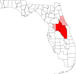
 Location in Orange County and the state of Florida | |
| Coordinates: 28°21′26″N 81°25′42″W / 28.35722°N 81.42833°WCoordinates: 28°21′26″N 81°25′42″W / 28.35722°N 81.42833°W | |
| Country |
|
| State |
|
| County | Orange |
| Area | |
| • Total | 3.8 sq mi (9.9 km2) |
| • Land | 3.8 sq mi (9.9 km2) |
| • Water | 0 sq mi (0 km2) |
| Elevation | 89 ft (27 m) |
| Population (2010) | |
| • Total | 14,321 |
| • Density | 3,700/sq mi (1,400/km2) |
| Time zone | Eastern (EST) (UTC-5) |
| • Summer (DST) | EDT (UTC-4) |
| FIPS code | 12-32967[1] |
| GNIS feature ID | 1853258[2] |
Hunter's Creek is an unincorporated community and census-designated place in Orange County, Florida, United States. It is part of the Orlando–Kissimmee–Sanford, Florida Metropolitan Statistical Area. The population was 14,321 at the 2010 census.[3] It has grown up around a large planned community named Hunter's Creek, though the CDP name given by the United States Census Bureau lacks the apostrophe.
The majority of the community was built in the late 1980s and 1990s, and some of the community is still under construction.
Features
Recognition
In 2011, CNN/Money and Money magazine ranked Hunter's Creek 10th on their list of the 100 best places to live in the United States. Criteria included financial, housing, education, quality of life, leisure and culture, and weather data.[4]
Schools
There are several schools that the children of the area are zoned to attend within Hunter's Creek. They are:
Elementary schools
- Hunter's Creek Elementary School (Principal, Oscar Sanchez)
- Endeavor Elementary School (Principal, Myrlene Kimbel)
- West Creek Elementary School (Principal, Janet Bittick)
- John Young Elementary School (Principal, Wendy Ivory)
Junior high (secondary, middle) schools
- Hunter's Creek Middle School (Principal, Amy McHale)
- Freedom Middle School (Principal, Douglas Szcinski)
High schools
- Freedom High School (Principal, Mr. Rolando Bailey)
Neighborhoods
There are several neighborhoods in Hunter's Creek. They are:
- Ashton
- Audubon Villas at Hunter's Creek
- Braddock Oaks
- Calabay Cove
- Camden Hunter's Creek
- Capri at Hunter's Creek Condominium
- Carrington
- Chalfont
- Chartres Gardens
- Chelsea Landing
- Colonial Grand at Heather Glen
- Colonial Grand at Hunter's Creek
- Cottages at Hunter's Creek
- Cypress Pointe
- Devlin Green
- Eagles Landing
- Fairways
- Falcon Pointe
- Foxhaven
- Glenhurst
- Golfview at Hunter's Creek
- Heather Glen
- Heritage Place
- Hunter's Isle
- Keaton's Crest
- Meadow Woods
- Mallard Cove
- Montara
- Ocita
- Orista Bay
- Osprey Links at Hunter's Creek
- Pace's Mill
- The Pointe
- Quail Lake
- Raintree
- Sandhill Trace
- Settlers Landing
- Tanglewood
- The Parks at Hunter's Creek
- Timucua Village
- Urbana Condominium
- Villanova at Hunter's Creek
- Westshire
and The Vistas:
- Casa Vista
- Flora Vista
- Mar Vista
- Palma Vista
- Sierra Vista
- Terra Vista
- Vida Vista
Parks
There are seven parks in Hunter's Creek that are available to all residents of the community.
Braddock Oak Park boasts mature trees which provide abundant shade and includes:
- Picnic tables
- Tot lot
- Walking path
Calabay Park is well known as a picnic spot. It includes:
- Chickee (pavilion)
- Picnic tables
- Tot lot
Eagle Park's community building is suitable for meetings and social events with up to 40 people attending. The park area includes:
- Basketball courts
- Chickee (pavilion)
- Community building / meeting rooms
- Fishing dock
- Multi-purpose field
- Picnic tables
- Racquetball courts
- Restrooms
- Soccer field
- Tennis courts
- Tot lot (shade structure)
- Volleyball courts
- Walking path
Mallard Pointe Park is a secluded park that includes:
- Basketball courts
- Chickee (pavilion)
- Picnic tables
- Portable toilets
- Tennis courts
- Tot lot (shade structure)
- Volleyball courts
- Walking path
Osprey Park is one of the biggest parks. Inside the Social Center, there is foosball, pool, table tennis, a large screen TV, video games, board games and cards. It also has a meeting room for up to 90 people. Many of the major events held in Hunter's Creek occur at Osprey Park. These include the Hunter's Creek Women's Association's Bunny in the Park and Fall Festival, and the HCCA Recreation and Special Events Department's Independence Day Celebration and Halloween (Hunter's Creep Nights) haunted house and hayride. It also includes:
- Basketball courts
- Baseball / softball fields
- Chickee (pavilion)
- Dog park
- Fishing
- Multi-purpose field
- Picnic tables
- Restrooms
- Shuffleboard
- Soccer fields
- Social center / meeting rooms
- Tennis courts
- Tot lot (shade structure)
- Volleyball courts
- Walking path
Vista Park is the first park located in the Vistas. It includes:
- Basketball courts
- Picnic tables
- Restrooms
- Soccer fields
- Swing set
- Tot lot (shade structure)
- Volleyball courts
- Walking path
Solar shade structures were recently on outdoor play areas that shields participants from the direct sunlight and keeps them cooler.
Lakes
All of these appear to be manmade or natural bodies of water that were altered.
- Mallard Lake (Florida)
- Lake Calabay
- Lake Barclay
- Lake Ocita
- Lake Timucua
- Eagle Lake
- Quail Lake
- Lake Fox
- Lake Gatlin
- Lake Kiawa
- Lake Tern
- Little Lake Tern
- Spoonbill Lake
- Lake Teal
- Gull Lake
- Lake Sandpiper
- Osprey Lake
- Crane Lake
- Dove Lake
- Lake Talova
- Heron Lake
- Egret Lake
- Loon Lake
Recreational activities and programs
- Soccer
Hunter's Creep Nights
Yearly, on the weekends leading up to Halloween, the Hunter's Creek community puts together the event. It usually includes food, games and activities as well as a haunted house. This varies in theme from year to year, but is a standing tradition and alternative to normal trick-or-treating fanfare. The event also allows children from the community to participate and be part of the haunted house and also constructing it.
Golf
Hunter's Creek Golf Club is an Orlando golf course featuring an 18-hole, par 72 championship layout. Hunter's Creek is conveniently located within minutes of Orlando area attractions and resorts.
Hunter's Creek Golf Club is a founding member of the Orlando Golf Trail. The Orlando Golf Trail is a group of 12 championship golf courses located along the interstate 4 corridor.
Media
- Life in Hunter's Creek - A magazine serving the community
- HCTV - A television channel serving the community
Geography
Hunter's Creek is located at 28°21′26″N 81°25′42″W / 28.35722°N 81.42833°W (28.357105, -81.428453).[5]
According to the United States Census Bureau, the CDP has a total area of 3.8 square miles (9.9 km2), all land.[6]
Demographics
As of the census[1] of 2000, there were 9,369 people, 3,460 households, and 2,498 families residing in the CDP. The population density was 841.3/km² (2,176.5/mi²). There were 3,870 housing units at an average density of 347.5/km² (899.0/mi²). The racial makeup of the CDP was 81.84% White, 5.18% African American, 0.14% Native American, 7.16% Asian, 0.02% Pacific Islander, 3.02% from other races, and 2.64% from two or more races. Hispanic or Latino of any race were 13.83% of the population.
There were 3,460 households out of which 37.7% had children under the age of 18 living with them, 62.3% were married couples living together, 6.7% had a female householder with no husband present, and 27.8% were non-families. 19.2% of all households were made up of individuals and 2.2% had someone living alone who was 65 years of age or older. The average household size was 2.68 and the average family size was 3.12.
In the CDP the population was spread out with 26.2% under the age of 18, 7.0% from 18 to 24, 37.3% from 25 to 44, 23.4% from 45 to 64, and 6.2% who were 65 years of age or older. The median age was 35 years. For every 100 females there were 97.7 males. For every 100 females age 18 and over, there were 95.3 males.
The median income for a household in the CDP was $67,775, and the median income for a family was $76,323. Males had a median income of $51,625 versus $35,625 for females. The per capita income for the CDP was $29,170. About 3.2% of families and 4.2% of the population were below the poverty line, including 3.8% of those under age 18 and 3.3% of those age 65 or over.
References
- 1 2 "American FactFinder". United States Census Bureau. Retrieved 2008-01-31.
- ↑ "US Board on Geographic Names". United States Geological Survey. 2007-10-25. Retrieved 2008-01-31.
- ↑ "Profile of General Population and Housing Characteristics: 2010 Demographic Profile Data (DP-1): Hunters Creek CDP, Florida". U.S. Census Bureau, American Factfinder. Archived from the original on September 11, 2013. Retrieved September 24, 2012.
- ↑ http://money.cnn.com/magazines/moneymag/bplive/2011/snapshots/PL1232967.html
- ↑ "US Gazetteer files: 2010, 2000, and 1990". United States Census Bureau. 2011-02-12. Retrieved 2011-04-23.
- ↑ "Geographic Identifiers: 2010 Demographic Profile Data (G001): Hunters Creek CDP, Florida". U.S. Census Bureau, American Factfinder. Archived from the original on September 11, 2013. Retrieved September 24, 2012.
External links
Municipalities and communities of Orange County, Florida, United States | ||
|---|---|---|
| Cities |  | |
| Towns | ||
| CDPs |
| |
| Unincorporated communities | ||
| Footnotes | ‡This populated place also has portions in an adjacent county or counties | |
| Attractions |
|  |
|---|---|---|
| Colleges and universities | ||
| Media |
| |
| Airports | ||
| Counties | ||
| Cities and towns 25k+ | ||
| Cities and towns 10k–25k | ||
‡ This populated place is included in the Orlando–Deltona–Daytona Beach, FL Combined Statistical Area. See also: | ||