Horb am Neckar
| Horb am Neckar | ||
|---|---|---|
 | ||
| ||
 Horb am Neckar | ||
| Coordinates: 48°26′43″N 8°41′28″E / 48.44528°N 8.69111°ECoordinates: 48°26′43″N 8°41′28″E / 48.44528°N 8.69111°E | ||
| Country | Germany | |
| State | Baden-Württemberg | |
| Admin. region | Karlsruhe | |
| District | Freudenstadt | |
| Area | ||
| • Total | 119.84 km2 (46.27 sq mi) | |
| Population (2015-12-31)[1] | ||
| • Total | 24,665 | |
| • Density | 210/km2 (530/sq mi) | |
| Time zone | CET/CEST (UTC+1/+2) | |
| Postal codes | 72160 | |
| Dialling codes | 07451, 07482, 07483, 07486 | |
| Vehicle registration | FDS | |
| Website | www.horb.de | |

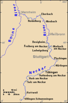
Horb am Neckar is a town in the southwest of the German state of Baden-Württemberg. It is located on the Neckar river, between Offenburg to the west (about 56 kilometres (35 mi) away) and Tübingen to the east (about 29 kilometres (18 mi) away). It has around 25,000 inhabitants, of whom about 6,000 live in the main town of Horb, and the remainder in 18 associated villages and districts which form part of the same municipality. If the entire municipality is counted, it is the largest town in the District of Freudenstadt.
Since 1 January 1981 Horb am Neckar has had the status of a Große Kreisstadt. It operates a combined administration with the neighbouring communities of Empfingen and Eutingen im Gäu.
Geography
Horb lies on the eastern margin of the northern part of the Black Forest just above the confluence of the river Grabenbach with the Neckar. The well-preserved old town, with an ancient castle and castle gardens and a typical market place where the town hall is still located, lies on a ridge overlooking the Neckar. The modern town and its outskirts stretch up the valleys of both rivers.
Constituent communities
In addition to the main town of Horb, the municipality includes a number of communities which are recognised within the terms of the 1970s Baden-Württemberg local government reform, that is they have an elected council and council chairman. These are Ahldorf, Altheim, Betra, Bildechingen, Bittelbronn, Dettensee, Dettingen, Dettlingen, Dießen, Grünmettstetten, Ihlingen, Isenburg, Mühlen, Mühringen, Nordstetten, Rexingen and Talheim, the last of which is made up of the formerly independent parishes of Obertalheim and Untertalheim. These are referred to formally (for example, in postal purposes) as Horb-Ahldorf, Horb-Altheim, etc. There are also other districts with distinct names, such as Hohenberg and Haugenstein, but no formally recognised boundaries, and numerous isolated hamlets with handfuls of inhabitants, such as Fronholzhof, Frundeckhof, Heidgrundhof, Hohenfichtehof, Markstallhof, Auchtert-Höfe, Breitenbaum-Höfe, Josefshof, Käppleshof, Kegelhof, Isenburger Höfe, Buchhöfe, Kreuzhöfe, Plattenhöfe, Ziegelhof, Heidehöfe, Kapellenhöfe, and Röteberg, not to mention even smaller settlements such as Neckarhausen or Priorberg.
Neighbouring municipalities
The following towns and communities border on Horb am Neckar, listing them in clockwise order starting in the east: Starzach (in Landkreis Tübingen), Haigerloch (Zollernalbkreis), Empfingen (Landkreis Freudenstadt), Sulz am Neckar (Landkreis Rottweil), Glatten, Schopfloch and Waldachtal (all in Landkreis Freudenstadt), and finally Haiterbach and Nagold, both in Landkreis Calw).
History
Horb was first documented as horv or horva, meaning swamp in Old High German, in 1090. Since Old High German had almost disappeared at that time, it is assumed that Horb is even older than that.
The swamp alongside the Neckar river forced the builders of the town to lay it out along the foothills of the mountain called Schütteberg. Today’s townscape is characterized by the whole historic city being located on top of a hill which makes it visible from any direction.
Horb was first documented in terms of being a town in 1228. In 1244 there was talk of a Schultheiß and in 1277 of a marketplace for the first time each.
Until 1305 Horb belonged to the count palatines of Tübingen, then to the counts of Hohenberg. In 1381 Horb became part of Austria (Further Austria). Later, in 1806, Horb became part of the kingdom Württemberg and one year later it turned the residence of the superior bailiwick Horb, whose borders had changed several times in the following years. In 1938 the superior bailiwick was transferred to the county Horb.
Between 1971 and 1975 a total of 18 surrounding municipals, including Betra, Dettensee, Dettingen, Dettlingen and Dießen that had formerly belonged to the county Hechingen, were annexed to Horb and thereby to the county Horb, or rather its legal successor, the county of Freudenstadt.
In the course of 1979 Horb exceeded the population figure of 20,000 for the first time which is why it had made a request to now become a major district town (Große Kreisstadt). This request was fulfilled by the government of the Land Baden-Württemberg as of the 1st January 1981.
Main sights

- The annual Renaissance fair "Maximilian-Ritterspiele" (Maximilian-Jousting) in Horb which takes place in the middle of June
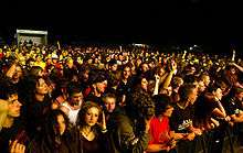
- The annual Rock festival "Mini-Rock-Festival" taking place in late August since 2005 organised voluntarily by adolescents
Notable residents

- around 1490, Georgius Eberhard, abbot at the monastery St. Blasien
- Veit Stoss, (1447-1533), sculptor, painter and engraver
- Sebastian Lotzer (around 1490-death unknown), author of the Memmingen items and 12 items in the Peasant War
- Martin Gerbert, (1720-1793) Prince Abbot of St. Blasien
- Kaspar Kaltenmoser, (1806-1867), genre painter
- Berthold Auerbach, (1812-1882), writer
- Johann Nepomuk Meintel, (1816-1872), sculptor and painter
- Johann Nepomuk Brischar, (1819-1897), Catholic church historian
- Wilhelm Erath, (1820-1908), merchant, Member of Parliament, mayor of the city 1874-1899
- Paul Leopold Haffner, (1829-1899), Bishop of Mainz
- Paul Schanz (1842-1905), Catholic theology professor at the University of Tübingen
- Maximilian Berlitz, (1852-1921), founder of the Berlitz language schools
- Lorenz Bock (1883-1948), President of Württemberg-Hohenzollern
- Georg Mayer, (1892-1973) economist, Rector of the University of Leipzig
- Eberhard Gönner, (1919-2012), historian, president of the Provincial Archives Directorate Baden-Württemberg
- Franz Blank, (1925-2008), longtime council chairman and deputy chairman of the Supervisory Board of the Porsche AG
- Norbert Schneider, (born 1935), lawyer and politician of the CDU
- Johannes Kreidler, (born 1946), since 1991 auxiliary bishop in the diocese of Rottenburg-Stuttgart
- Carmina Brenner, (born 1957), 1996-2007 Member of Parliament (CDU), since 2007 President of the State Statistical Office Baden-Württemberg
- Pascal Reinhardt, (born 1992), football player
People connected to the town
- Michael Jung (equestrian), German equestrian and double Olympic gold medal winner 2012
International relations
Horb am Neckar is twinned with:
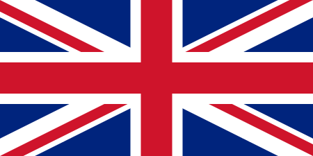 Haslemere, United Kingdom, since 1991
 Salins-les-Bains, France, since 1991
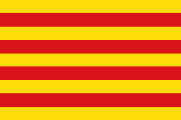 San Just Desvern, Catalonia, Spain, since 1999
See also
References
External links
Towns and municipalities in Freudenstadt (district) | ||
|---|---|---|