Sardarapat, Armenia
Coordinates: 40°08′10″N 44°00′50″E / 40.13611°N 44.01389°E
| Sardarapat Սարդարապատ | |
|---|---|
 Sardarapat | |
| Coordinates: 40°08′10″N 44°00′50″E / 40.13611°N 44.01389°E | |
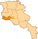
| Country | Armenia |
| Province | Armavir |
| Population (2011) | |
| • Total | 5,192 |
Sardarapat (Armenian: Սարդարապատ), is a major village in the Armavir province of Armenia. The settlement was originally known as Sardarapat until 1935 when it was renamed Hoktember (October). In 1967, the village of Norapat was absorbed by Hoktember.[1] However, the original name of the village was restored in 2009.
The name Sardarapat is derived from the major Persian fortress of Sardari Berd, built around 1810 by the last Persian Qajar governor of the Erivan Khanate; Sardar Hosein Qoli Khan Qajar, with British technical assistance using stones taken from the ruins of ancient Armavir. Many of the stones are still bearing traces of cuneiform inscriptions.
The town was set as administrative centre for the Sardarapat district and summer residence of the Khan of Erivan. The Sardar's fortress was taken by the Russians under General Paskevich in 1828, despite stout defense by Sardar Hasan Khan.
Currently, almost no trace of the fortress is left.
In 1935, Sardarapat was renamed Hoktember, Armenian for October, in the honour of the October Revolution of 1917.
The Sardarapat Memorial commemorating the Battle of Sardarapat is located in the nearby village of Araks.
References
- ↑ Kiesling, Rediscovering Armenia, p. 37, available online at the US embassy to Armenia's website
- World Gazetteer: Armenia – World-Gazetteer.com
- Sardarapat, Armenia at GEOnet Names Server
- Brady Kiesling, Rediscovering Armenia, p. 37; original archived at Archive.org, and current version online on Armeniapedia.org.
- Report of the results of the 2001 Armenian Census, National Statistical Service of the Republic of Armenia