Aragats, Armavir
Coordinates: 40°13′06″N 44°13′58″E / 40.21833°N 44.23278°E
| Aragats Արագած | |
|---|---|
 Aragats | |
| Coordinates: 40°13′06″N 44°13′58″E / 40.21833°N 44.23278°E | |
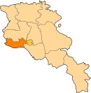
| Country | Armenia |
| Marz (Province) | Armavir Province |
| Population (2008) | |
| • Total | 3,206 |
| Time zone | (UTC+4) |
| • Summer (DST) | (UTC) |
Aragats (Armenian: Արագած, until 1946, Khznauz) is a village in the Armavir Province of Armenia. The village's church, dedicated to Saint Stepanos, dates to 1870. There is a Urartian fortress nearby.
References
- Aragats, Armavir at GEOnet Names Server
- World Gazeteer: Armenia – World-Gazetteer.com
- Report of the results of the 2001 Armenian Census, National Statistical Service of the Republic of Armenia
- Brady Kiesling, Rediscovering Armenia, p. 36; original archived at Archive.org, and current version online on Armeniapedia.org.
This article is issued from Wikipedia - version of the 10/16/2016. The text is available under the Creative Commons Attribution/Share Alike but additional terms may apply for the media files.