Heppner, Oregon
| Heppner, Oregon | |
|---|---|
| City | |
|
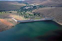
Heppner from above Willow Creek Lake | |
| Nickname(s): Gateway to the Blues | |
 Location in Oregon | |
| Coordinates: 45°21′22″N 119°33′10″W / 45.35611°N 119.55278°WCoordinates: 45°21′22″N 119°33′10″W / 45.35611°N 119.55278°W | |
| Country | United States |
| State | Oregon |
| County | Morrow |
| Incorporated | 1887 |
| Government | |
| • Mayor | Ronald "Skip" Matthews |
| Area[1] | |
| • Total | 1.24 sq mi (3.21 km2) |
| • Land | 1.23 sq mi (3.19 km2) |
| • Water | 0.01 sq mi (0.03 km2) |
| Elevation | 2,192 ft (668 m) |
| Population (2010)[2] | |
| • Total | 1,291 |
| • Estimate (2012[3]) | 1,289 |
| • Density | 1,049.6/sq mi (405.3/km2) |
| Time zone | Pacific (UTC-8) |
| • Summer (DST) | Pacific (UTC-7) |
| ZIP code | 97836 |
| Area code(s) | 458 and 541 |
| FIPS code | 41-33550[2] |
| GNIS feature ID | 1121763[4] |
| Website | www.cityofheppner.com |
The city of Heppner is the county seat of Morrow County, Oregon, United States. The population was 1,291 at the 2010 census. Heppner is part of the Pendleton-Hermiston Micropolitan Area.
Geography
Heppner is at an elevation of 2,192 feet (668 m)[4] between the Columbia River to the north and the Blue Mountains to the southeast.[5] The city is along Oregon Route 74, about 60 miles (97 km) southwest of Pendleton and 185 miles (298 km) east of Portland.[5][6]
Route 74 forms part of the Blue Mountain Scenic Byway, a 130-mile (210 km) set of roads connecting Interstate 84 (I-84) along the Columbia River with the North Fork John Day River in the Blue Mountains. Part of the route follows the Willow Creek drainage through Heppner.[7]
Heppner is upstream of Lexington, Ione, and Arlington.[5] According to the United States Census Bureau, the city has a total area of 1.24 square miles (3.21 km2), of which, 1.23 square miles (3.19 km2) is land and 0.01 square miles (0.03 km2) is water.[1]
Climate
| Climate data for Heppner, Oregon (1981–2010) | |||||||||||||
|---|---|---|---|---|---|---|---|---|---|---|---|---|---|
| Month | Jan | Feb | Mar | Apr | May | Jun | Jul | Aug | Sep | Oct | Nov | Dec | Year |
| Average high °F (°C) | 43.3 (6.3) |
47.3 (8.5) |
55.1 (12.8) |
61.3 (16.3) |
69.2 (20.7) |
76.9 (24.9) |
85.9 (29.9) |
85.7 (29.8) |
76.6 (24.8) |
64.3 (17.9) |
50.7 (10.4) |
41.2 (5.1) |
63.1 (17.3) |
| Average low °F (°C) | 27.8 (−2.3) |
29.1 (−1.6) |
33.9 (1.1) |
37.4 (3) |
43.7 (6.5) |
49.0 (9.4) |
53.7 (12.1) |
53.5 (11.9) |
46.9 (8.3) |
38.7 (3.7) |
32.6 (0.3) |
26.1 (−3.3) |
39.4 (4.1) |
| Average precipitation inches (mm) | 1.43 (36.3) |
1.11 (28.2) |
1.49 (37.8) |
1.50 (38.1) |
1.68 (42.7) |
1.36 (34.5) |
0.34 (8.6) |
0.37 (9.4) |
0.54 (13.7) |
1.13 (28.7) |
1.59 (40.4) |
1.34 (34) |
13.88 (352.6) |
| Average snowfall inches (cm) | 3.9 (9.9) |
2.3 (5.8) |
0.4 (1) |
0.1 (0.3) |
0.0 (0) |
0.0 (0) |
0.0 (0) |
0.0 (0) |
0.0 (0) |
0.2 (0.5) |
1.0 (2.5) |
4.2 (10.7) |
12.2 (31) |
| Source: NOAA[8] | |||||||||||||
History
Early days
The community is named after Henry Heppner, who partnered with Jackson L. Morrow to open the first store in Heppner in 1873. In that same year, a post office was established in Heppner with George H. Stansbury as the postmaster.[9] This was also the year that a mail and stagecoach line began operations between Pendleton and The Dalles, passing through Heppner.[10]
Morrow, later elected to the state legislature while Heppner was still part of Umatilla County, was instrumental in carving out a new county. The legislature named the new county in his honor.[10]
After Morrow County's creation in 1885, Heppner became the temporary county seat. In 1886, it narrowly defeated Lexington in an election to determine the permanent seat.[11] Heppner was incorporated in the following year.[12] In 1888, the Oregon Railroad and Navigation Company completed a railroad spur from the Columbia River up the Willow Creek drainage to Heppner.[10]
Flood of 1903
Heppner was almost destroyed by a flash flood on June 14, 1903.[13] The flood was precipitated by a sudden cloudburst and accompanying hail that caused a debris dam collapse and flash flooding, notably on Willow Creek.[13] A wall of water and debris swept down the creeks and canyons and through the city. It has been estimated that 238 people (a quarter of the city's population) drowned, making it the deadliest natural disaster in Oregon's history.[13] Property damage was reported at nearly $1 million. The nearby cities of Ione and Lexington also sustained significant damage.[13] In 1983, the Willow Creek Dam at the outskirts of the city was finished.[13]
Rebuilding
The railroad and a growing network of roads had by the early decades of the 20th century made Heppner a trade center and distribution point for regional farm products including wheat, alfalfa, sheep, cattle, horses, and hogs. Despite the flood and two fires in 1918 that destroyed City Hall, the library, many businesses, and more than 30 homes, the community rebuilt. One of its creations, the Heppner Hotel, opened in 1920 and, housing a variety of businesses over the years, it served as a community gathering place through 1972, when its last restaurant closed.[10]
Demographics
| Historical population | |||
|---|---|---|---|
| Census | Pop. | %± | |
| 1880 | 318 | — | |
| 1890 | 675 | 112.3% | |
| 1900 | 1,146 | 69.8% | |
| 1910 | 880 | −23.2% | |
| 1920 | 1,324 | 50.5% | |
| 1930 | 1,190 | −10.1% | |
| 1940 | 1,140 | −4.2% | |
| 1950 | 1,648 | 44.6% | |
| 1960 | 1,661 | 0.8% | |
| 1970 | 1,429 | −14.0% | |
| 1980 | 1,498 | 4.8% | |
| 1990 | 1,412 | −5.7% | |
| 2000 | 1,395 | −1.2% | |
| 2010 | 1,291 | −7.5% | |
| Est. 2015 | 1,287 | [14] | −0.3% |
| source:[2][15] | |||
2010 census
As of the census of 2010, there were 1,291 people, 559 households, and 370 families residing in the city. The population density was 1,049.6 inhabitants per square mile (405.3/km2). There were 647 housing units at an average density of 526.0 per square mile (203.1/km2). The racial makeup of the city was 92.5% White, 0.2% African American, 1.2% Native American, 0.3% Asian, 2.6% from other races, and 3.3% from two or more races. Hispanic or Latino of any race were 3.7% of the population.[2]
There were 559 households of which 26.1% had children under the age of 18 living with them, 53.3% were married couples living together, 8.2% had a female householder with no husband present, 4.7% had a male householder with no wife present, and 33.8% were non-families. 29.3% of all households were made up of individuals and 14.5% had someone living alone who was 65 years of age or older. The average household size was 2.30 and the average family size was 2.78.[2]
The median age in the city was 45.9 years. 22.5% of residents were under the age of 18; 6.5% were between the ages of 18 and 24; 19.6% were from 25 to 44; 29.8% were from 45 to 64; and 21.5% were 65 years of age or older. The gender makeup of the city was 50.6% male and 49.4% female.[2]
2000 census

As of the census of 2000, there were 1,395 people, 583 households, and 398 families residing in the city. The population density was 1,138.5 people per square mile (437.9/km²). There were 660 housing units at an average density of 538.7 per square mile (207.2/km²). The racial makeup of the city was 96.70% White, 1.00% Native American, 0.43% Asian, 1.51% from other races, and 0.36% from two or more races. Hispanic or Latino of any race were 1.58% of the population.[2]
There were 583 households out of which 28.8% had children under the age of 18 living with them, 56.6% were married couples living together, 7.5% had a female householder with no husband present, and 31.7% were non-families. 28.1% of all households were made up of individuals and 14.8% had someone living alone who was 65 years of age or older. The average household size was 2.36 and the average family size was 2.88.[2]
In the city the population was spread out with 24.5% under the age of 18, 5.9% from 18 to 24, 24.3% from 25 to 44, 24.9% from 45 to 64, and 20.3% who were 65 years of age or older. The median age was 42 years. For every 100 females there were 100.7 males. For every 100 females age 18 and over, there were 92.9 males.[2]
The median income for a household in the city was $33,421, and the median income for a family was $42,500. Males had a median income of $37,381 versus $20,714 for females. The per capita income for the city was $16,729. About 11.1% of families and 13.9% of the population were below the poverty line, including 18.9% of those under age 18 and 7.0% of those age 65 or over.[2]
Annual cultural events
Heppner hosts an annual "A Wee Bit O'Ireland" celebration around Saint Patrick's Day.[16][17]
Economy and education
Heppner is served by the Morrow School District, which includes Heppner Junior/Senior High School and Heppner Elementary.[18]
As of 2002, the five largest employers in Heppner were Morrow County, the Morrow County Health District, the Morrow County School District, the Heppner Ranger District, and the Bank of Eastern Oregon.[6]
Notable people
- John Kilkenny, federal judge
- Greg Smith, Oregon State Representative, District 57
References
- 1 2 "2010 Census Gazetteer Files". United States Census Bureau. Retrieved June 20, 2013.
- 1 2 3 4 5 6 7 8 9 10 "American FactFinder". U.S. Census Bureau. Retrieved June 20, 2013.
- ↑ "Population Estimates". United States Census Bureau. Retrieved June 2, 2013.
- 1 2 "Heppner". Geographic Names Information System. United States Geological Survey. November 28, 1980. Retrieved July 19, 2013.
- 1 2 3 The 2013 Road Atlas. Chicago, Illinois: Rand McNally. pp. 84, 85. ISBN 978-052-80062-2-7.
- 1 2 "Heppner Community Profile". Oregon Infrastructure Finance Authority. 2009. Retrieved July 19, 2013.
- ↑ Ostertag, Rhonda (2004). Backroads of Oregon: Your Guide to Oregon's Most Scenic Backroad Adventures. Stillwater, Minnesota: Voyageur Press. pp. 105–06. ISBN 0-89658-081-4.
- ↑ "NOWData - NOAA Online Weather Data". National Oceanic and Atmospheric Administration. Retrieved May 5, 2013.
- ↑ McArthur, Lewis A.; Lewis L. McArthur (2003) [1928]. Oregon Geographic Names (7th ed.). Portland, Oregon: Oregon Historical Society Press. pp. 463–64. ISBN 0-87595-277-1.
- 1 2 3 4 Hedman, Arnie; Belsma, Ronnie; Lynch, James (April 23, 1982). "National Register of Historic Places Registration Form: Heppner Hotel" (PDF). National Park Service. Retrieved July 20, 2013.
- ↑ Lynch, James E.; Derickson, Patrick M. (August 17, 1984). "National Register of Historic Places Registration Form: Morrow County Courthouse" (PDF). National Park Service. Retrieved July 18, 2013.
- ↑ "Heppner Community Profile". Infrastructure Finance Authority. 2009. Retrieved July 18, 2013.
- 1 2 3 4 5 Baker, Jeff (September 2, 2009). " 'Calamity' : Discovering Oregon's Deadliest Natural Disaster". The Oregonian. Retrieved September 3, 2009.
- ↑ "Annual Estimates of the Resident Population for Incorporated Places: April 1, 2010 to July 1, 2015". Retrieved July 2, 2016.
- ↑ Moffatt, Riley Moore (1996). Population History of Western U.S. Cities and Towns, 1850–1990. Lanham, Maryland: Scarecrow Press. p. 210. ISBN 978-0-8108-3033-2.
- ↑ Malgesini, Tammy (March 10, 2011). "Leprechauns Plan Wee Bit o' Fun". East Oregonian. Pendleton, Oregon. Retrieved June 20, 2013.
- ↑ "31st Annual "A Wee Bit O'Ireland"". Heppner Chamber of Commerce. Retrieved July 19, 2013.
- ↑ "Our Schools". Morrow County School District. 2012. Retrieved June 28, 2012.
Further reading
- Byrd, Joann Green (2009). Calamity: The Heppner Flood of 1903. University of Washington Press. ISBN 0295989416.
- Holbrook, Stewart (1952). "Disaster in June". The Far Corner: A Personal View of the Pacific Northwest. The Macmillan Company.
External links
![]() Media related to Heppner, Oregon at Wikimedia Commons
Media related to Heppner, Oregon at Wikimedia Commons
Municipalities and communities of Morrow County, Oregon, United States | ||
|---|---|---|
| Cities |  | |
| Unincorporated communities | ||
| Ghost town | ||