Hartford, Georgia
| Hartford | |
|---|---|
| Unincorporated community | |
 Hartford  Hartford Location within the state of Georgia | |
| Coordinates: 32°17′9″N 83°26′57″W / 32.28583°N 83.44917°WCoordinates: 32°17′9″N 83°26′57″W / 32.28583°N 83.44917°W | |
| Country | United States |
| State | Georgia |
| County | Pulaski |
| Elevation | 256 ft (78 m) |
| Time zone | Eastern (EST) (UTC-5) |
| • Summer (DST) | EDT (UTC-4) |
| GNIS feature ID | 356213 |
Hartford (also Old Hartford) is an unincorporated community in Pulaski County, Georgia, United States. It lies a short distance east of the city of Hawkinsville, the county seat of Pulaski County. Hartford sits at the intersection of Alternate U.S. Route 129 with State Routes 26, 27, 230, 257, and U.S. Route 341.[1] Its elevation is 256 feet (78 m).[2]
Hartford served as seat of Pulaski County from the formation of the county in 1809 until 1836 when the seat was transferred to Hawkinsville.[3]
See also
List of county seats in Georgia (U.S. state)
References
- ↑ Rand McNally. The Road Atlas '05. Skokie: Rand McNally, 2005, p. 28.
- ↑ U.S. Geological Survey Geographic Names Information System: Hartford, Georgia, Geographic Names Information System, 1979-09-25. Accessed 2007-12-23.
- ↑ Hellmann, Paul T. (May 13, 2013). Historical Gazetteer of the United States. Routledge. p. 232. Retrieved 30 November 2013.
Municipalities and communities of Pulaski County, Georgia, United States | ||
|---|---|---|
| City | 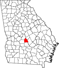 | |
| Unincorporated community | ||
This article is issued from Wikipedia - version of the 10/24/2016. The text is available under the Creative Commons Attribution/Share Alike but additional terms may apply for the media files.