Harding Park, Bronx

Harding Park also known as "Little Puerto Rico" is a working class residential neighborhood geographically located in the Clason Point section of the Bronx, a borough in New York City. The neighborhood is part of Bronx Community Board 9.[1] Its boundaries, starting from the north and moving clockwise are: O'Brien Avenue to the north, White Plains Road to the east, the East River to the south, and the Bronx River to the west. White Plains Road is the primary thoroughfare through Harding Park. ZIP code is 10473. The area is patrolled by the 43rd Precinct, Sector Adam located at 900 Fteley Avenue in the Soundview section of the Bronx. As in Silver Beach and Edgewater Park in Throggs Neck, a peninsular location and irregular street grid incongruent with the main Bronx grid lend an air of isolation.
History
The small peninsula of the Bronx defined by the Bronx River, Pugsley's Creek, and the East River is known as Clason (pronounced Clawson) Point, named for 18th Century merchant Isaac Clason who purchased what was previously known as Cornell's Neck in 1793; the land stayed in the family until they sold it in 1855.
The region's first residents were the Siwanoy Indians, who spoke Algonquian. Europeans began settling the region in the early 17th century, and the Cornell family built the first permanent European settlement in the spit of land first known as Snakipins by the Indians, then Cornells Neck (named after Thomas Cornell) and later Clason Point. In the 1640s a series of skirmishes between the Cornells and the Siwanoy, known as the Pig Wars, were led by Chief Wampage, the Siwanoy sachem believed to be the Indian leader who killed Anne Hutchinson and her children in 1643 at Split Rock, now in the northern Bronx. A passing ship rescued the Cornells, and they returned to their home the year after Wampage's last raid. Britisher Thomas Pell arrived at a treaty in 1654 with several Siwanoy sachems, including Wampage, that the Dutch authorities didn't recognize. This disagreement was rendered moot in 1664 when the British fleet appeared in the harbor and the Dutch capitulated.
By the middle 19th century Clason Point had many farmhouses, despite its poor drainage. Even today the main shopping area is fairly distant, along Story Avenue, the Bruckner Expressway and White Plains Road. Its seaside location and views attracted seaside resorts, dancehalls and amusement parks in the early 20th Century, served by a ferry from College Point, Queens.
In the early 1920s Thomas Higgs, who owned about 100 acres (0.40 km2) of beachfront property, began leasing tents to visitors and the area became a summer bungalow colony named for President Harding. After World War II these became permanent year-round residences due to a housing shortage, eventually sheltering over 250 families.
Harding Park survived the attempt of Robert Moses to tear down what he called the "Soundview Slums" but became City property in 1979. Three years later, in 1982, Harding Park Homeowners Association, the first cooperatively owned low and moderate-income community in the city, was formed.

After a wave of arson ravaged the low income communities of New York City throughout the 1970s, some of the residential structures in Harding Park were left seriously damaged or destroyed. At the same time, much of the undeveloped land in the community was left to rot. Many homes have been rehabilitated and also many subsidized multi-unit townhouses have been or are being built on vacant lots across the neighborhood. Many in the community however feel the new development has led to new problems.
The infrastructure of the community has not been updated in many years. Many streets flood after periods of heavy rain. Bruckner Plaza, the nearest retail strip, is approximately 1 mile away, has several big box stores such as Old Navy. Public transportation are the BX36 and BX39 buses.
Land use and terrain
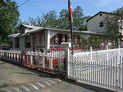
Harding Park is dominated by detached bungalows very closely set, many of them built off the grid. The total land area is roughly 1-square-mile (2.6 km2). The area is low lying and flat.
Demographics
As of the census[2] of 2000, the two census tracts that make up the neighborhood have a population of 5,859. The racial makeup of the neighborhood is 6.53% White, 19.59% African American, and 2.76% from other races. 80.54% of the population are Hispanic or Latino of any race.[3]
Over 20% of the population in Harding Park lives under the poverty line. The remaining 80% of the population in Harding Park lives above the poverty line. Puerto Ricans account for the largest ethnic group.
References
- ↑ Bronx Community Boards, New York City. Accessed March 20, 2008.
- ↑ "American FactFinder". United States Census Bureau. Retrieved 2008-01-31.
- ↑ Bronx Community District 9
External links
- Forgotten New York Harding Park
| Wikimedia Commons has media related to Harding Park, Bronx. |

Coordinates: 40°48′34″N 73°51′23″W / 40.8094444°N 73.8563889°W