H. E. Bailey Turnpike
| |
|---|---|
 | |
| Route information | |
| Maintained by OTA | |
| Length: |
86.4 mi[1] (139.0 km) 8.2 mi (13.2 km) Norman Spur[1] |
| Existed: | April 23, 1964[2] – present |
| Component highways: |
|
| Major junctions | |
| West end: |
|
| East end: |
|
| Highway system | |

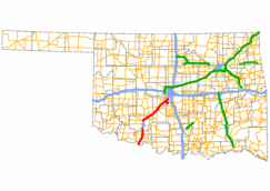
The H. E. Bailey Turnpike is an 86.4-mile (139.0 km) toll road in the southwestern region of the U.S. state of Oklahoma. The route, opened on April 23, 1964, is a four-lane limited access highway that connects Oklahoma City to Lawton in its northern section and Lawton to Wichita Falls along its southern section. The turnpike also includes an 8.2-mile (13.2 km) spur route that leads toward Norman, Oklahoma. Since 1982, it has been signed as a part of Interstate 44.[3] Travel along the full length of the toll road costs $4.75 for a two-axle vehicle.
Route description
The H. E. Bailey Turnpike takes a generally south to north route from Wichita Falls to Lawton before turning northeast toward Oklahoma City. The turnpike's 25 miles (40 km) southern section begins at US-70, 6 miles (9.7 km) north of the Texas state line. The turnpike becomes toll free when it arrives in Lawton at State Highway 36. After leaving the Lawton/Fort Sill area it once again become a toll road after the US-62, US-277 interchange 6 miles (9.7 km) north of Lawton. The northern 61.4-mile (98.8 km) section of the H.E. Bailey Turnpike continues toward Chickasha and ends at the interchange of US-62 north of Newcastle where it continues to Oklahoma City as an urban freeway.[4]
Aside from the mainline, the turnpike also consists of a 8.2-mile (13.2 km) extension southwest of Newcastle also referred to as the H. E. Bailey Norman Spur. It connects I-44 and SH-4 to SH-9 and provides a shorter route to Norman when traveling from Lawton.[5]
History
Ideas for connecting Lawton and Oklahoma City started in 1953. The state highways between Oklahoma City and Lawton, were dangerously narrow, which included many 'cramped, death-trap' bridges. The route was not part of any federal interstate highway system plans, so only a turnpike was feasible.[6] Oklahoma Senate Bill 454, which amended House Bill 933 that authorized creation of the Will Rogers Turnpike, allowed creation of a southwest turnpike and a proposed turnpike connecting Oklahoma City toward Wichita, Kansas, which later became Interstate 35.[2]
Both HB 933 and SB 454 were submitted as State Question 359 and 360 and passed on January 26, 1954. On July 1960, an economic feasibility study was completed for the H.E. Bailey Turnpike and on November 1961, $56 Million in bonds were issued for the turnpike's construction.[2] The north section of the H. E. Bailey from southwest Oklahoma City to north Lawton was completed on March 1, 1964. The south section from south Lawton to the Texas border was completed on April 23, 1964.[2]
In 1982, as part of the Oklahoma's 75th statehood "Diamond Jubilee" celebrations, I-44 was signed through Oklahoma City to the Red River encompassing the turnpike.[3][7] On October 19, 2001, the H. E. Bailey Norman Spur connecting I-44 to State Highway 9 was opened.[2][8]
The route's namesake, H. E. Bailey, served as the city manager of Oklahoma City from 1941 to 1944, and later as the director of the Oklahoma Department of Transportation.[9]
Tolls
A two-axle vehicle currently pays $4.75 ($4.45 with Pikepass) to drive the full length of the Turnpike and an additional $0.55 ($0.50 with Pikepass) to drive the Norman Spur.[1]
Full toll plazas on the H.E. Bailey Turnpike are located near the intersection with the H.E. Bailey Norman Spur, southwest of Chickasha, and under the overpass at SH-5 (Walters exit). Unattended ramp toll plazas are located at US-62 (Chickasha/Anadarko exit - northbound exit and southbound entrance only), US-277 (Elgin/Fletcher exit - northbound exit and southbound entrance only) on the I-44 portion of the turnpike and at SH-76 (Blanchard/Tuttle) on the Norman Spur.
Services
Law enforcement along the H. E. Bailey Turnpike is provided by Oklahoma Highway Patrol Troop YC, a special troop assigned to the turnpike.[10]
The turnpike has two service areas with both located in the median of the highway. The Walters Service Area is located north of exit number 20. The Chickasha Service Area is located north of exit number 83. Both service areas offer food, gas, and a convenience store.[4]
Exit list
Mainline
| County | Location | mi | km | Exit | Destinations | Notes |
|---|---|---|---|---|---|---|
| Cotton | | 5.65 | 9.09 | 5 | Last free exit eastbound, eastern terminus of US-277/US-281 concurrency | |
| Walters | 20 | Walters toll plaza is located at this interchange | ||||
| Comanche | | 30 | Last free exit westbound, western terminus of US-277/US-281 concurrency | |||
| Lawton | Pioneer Expressway (free highway through Lawton) | |||||
| | 46 | Last free exit eastbound, eastbound exit and westbound entrance, eastern terminus of US-62/US-277/US-281 concurrency | ||||
| Elgin | 53 | |||||
| | 62 | Fletcher, Cyril, Sterling | Westbound exit and eastbound entrance | |||
| Grady | | Toll plaza | ||||
| Chickasha | 80 | |||||
| 83 | ||||||
| | Toll plaza | |||||
| | 99A | H. E. Bailey Spur – Blanchard, Norman | ||||
| | 99B | |||||
| McClain | Newcastle | 107 | Last free exit westbound, western terminus of US-62 concurrency | |||
1.000 mi = 1.609 km; 1.000 km = 0.621 mi
| ||||||
H. E. Bailey Norman Spur
| County | Location | mi[11] | km | Destinations | Notes |
|---|---|---|---|---|---|
| Grady | | 0.0 | 0.0 | Westbound continuation of turnpike spur | |
| | 0.0 | 0.0 | |||
| | Toll plaza | ||||
| McClain | | 3.7 | 6.0 | ||
| | 4.1 | 6.6 | |||
| | 4.1 | 6.6 | Eastbound continuation of turnpike spur | ||
| 1.000 mi = 1.609 km; 1.000 km = 0.621 mi | |||||
See also
References
- 1 2 3 Oklahoma Turnpike Authority. "Toll/Fares Chart". Retrieved 2011-04-18.
- 1 2 3 4 5 Oklahoma Turnpike Authority. "OTA History". Retrieved 2011-04-18.
- 1 2 "I-240 Section Changing to I-44". The Daily Oklahoman. 1982-10-09.
- 1 2 Official State Highway Map (Map) (2009-2010 ed.). Oklahoma Department of Transportation.
- ↑ "Bailey Turnpike's new spur to open". The Oklahoman. 2001-10-18.
- ↑ Harris, Fred R. (2008). Does People do it: a memoir. University of Oklahoma Press. p. 46. ISBN 978-0-8061-3913-5.
- ↑ 1983 Official State Map (Map) (1983 ed.). Oklahoma Department of Transportation.
- ↑ The Oklahoman (2001-10-18). "Bailey Turnpike's new spur to open".
- ↑ "City of Oklahoma City: City Manager". Retrieved 2011-09-23.
- ↑ "Oklahoma Highway Patrol". Retrieved 2008-04-05.
- ↑ Google Maps (Map). Cartography by NAVTEQ. Google Inc. Retrieved 2007-10-21.