Muskogee Turnpike
| |
|---|---|
 | |
| Route information | |
| Length: | 53.1 mi (85.5 km) |
| Existed: | October 16, 1969 – present |
| Major junctions | |
| West end: |
|
|
| |
| East end: |
|
| Highway system | |

The Muskogee Turnpike, also designated State Highway 351 (SH-351), is a toll road in eastern Oklahoma.
Route description
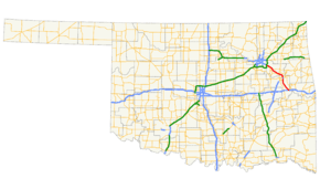
Opened in 1969, the 53-mile (85.2 km) route begins at the Broken Arrow Expressway (SH-51) southeast of Tulsa, near an intersection with the Creek Turnpike. The Turnpike ends at Interstate 40 west of Webbers Falls. The Muskogee Turnpike's north section is connected to its south section by Oklahoma 165.
History
The Muskogee Turnpike originally bore no numbered designation. On March 10, 2014, the Oklahoma Transportation Commission unanimously approved a motion to apply the SH-351 designation to the turnpike.[1][2]
Tolls
A two-axle vehicle currently pays $3.00 ($2.90 with Pikepass) to drive the full length of the Turnpike. There are two toll collection plazas located along the length of the Muskogee Turnpike. The Muskogee Main Line Plaza is located approximately 5 miles (8.0 km) south of the city of Muskogee and has an inline Pikepass lane, an exact change lane, and an attended collection lane. Speed limits through this plaza are 30 miles per hour (48 km/h) for all vehicles. The Coweta Main Line Plaza is located approximately 15 miles (24 km) north of the city of Muskogee at the Coweta exit, and has four collection lanes: one exact change lane, two attended lanes, and a Pikepass lane that is independent from the plaza. Speed limits at this plaza are 30 miles per hour (48 km/h) for all vehicles, except Pikepass vehicles, which bypass the collection plaza.
Services
Located approximately 10 miles (16 km) north of the city of Muskogee is a newly renovated concession plaza which reopened in April 2011. This concession plaza has an EZ Go gasoline station selling Phillips 66 gasoline, as well as a McDonald's restaurant. The concession plaza has free restrooms, is open 24 hours a day, and is located in the median for easy access from both travel directions. Groundwork was laid out for a second concession plaza just north of the Muskogee Main Line collection plaza; however this plaza was never built, and all pavement and ramps have since been removed.
Law enforcement along the Muskogee Turnpike is provided by Oklahoma Highway Patrol Troop XB, a special troop assigned to the turnpike.[3]
Exit list
| County | Location | mi | km | Exit | Destinations | Notes |
|---|---|---|---|---|---|---|
| Wagoner | Broken Arrow | 0.0 | 0.0 | |||
| 0.0 | 0.0 | |||||
| | Toll plaza | |||||
| | 13 | |||||
| | 19 | Eastbound exit only | ||||
| | 26 | Westbound toll | ||||
| Muskogee | | 33 | Hyde Park Road – Port of Muskogee | Actual road is Harris Road | ||
| | Free section begins | |||||
| Muskogee | 34 | 55 | ||||
| 34 | 55 | |||||
| 35 | 56 | Gibson Street | ||||
| 36 | 58 | Chandler Road, Hancock Street | Hancock St signed eastbound only | |||
| 37 | 60 | Eastbound exit only | ||||
| 37 | To | Westbound exit only | ||||
| | Free section ends | |||||
| | 55 | Eastbound exit only | ||||
| | 56A | |||||
| | 56B | Eastern terminus | ||||
1.000 mi = 1.609 km; 1.000 km = 0.621 mi
| ||||||
See also
References
- ↑ Killman, Curtis (2014-03-11). "Cable Barriers Approved For Six Stretches of Oklahoma Highways". Tulsa World. Retrieved 2014-03-26.
- ↑ Oklahoma Transportation Commission (2014-03-10). "Minutes for the Special Transportation Committee Meeting" (PDF). Retrieved 2014-03-26.
- ↑ "Oklahoma Highway Patrol". Retrieved 2008-04-05.