Groveport, Ohio
| Groveport, Ohio | |
|---|---|
| City | |
|
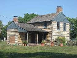
One of the Groveport Log Houses | |
| Motto: "Central Ohio's Hometown" | |
 Location of Groveport, Ohio | |
 Location of Groveport in Franklin County | |
| Coordinates: 39°51′22″N 82°53′26″W / 39.85611°N 82.89056°WCoordinates: 39°51′22″N 82°53′26″W / 39.85611°N 82.89056°W | |
| Country | United States |
| State | Ohio |
| County | Franklin |
| Area[1] | |
| • Total | 8.79 sq mi (22.77 km2) |
| • Land | 8.56 sq mi (22.17 km2) |
| • Water | 0.23 sq mi (0.60 km2) |
| Elevation[2] | 741 ft (226 m) |
| Population (2010)[3] | |
| • Total | 5,363 |
| • Estimate (2012[4]) | 5,540 |
| • Density | 626.5/sq mi (241.9/km2) |
| Time zone | Eastern (EST) (UTC-5) |
| • Summer (DST) | EDT (UTC-4) |
| ZIP codes | 43125, 43195, 43196, 43198, 43199 |
| Area code(s) | 614 |
| FIPS code | 39-32606[5] |
| GNIS feature ID | 1062797[2] |
Groveport is a city in Franklin County, Ohio, United States. The population was 5,363 at the 2010 census.
Groveport was the hometown of John Solomon Rarey, a 19th-century horse whisperer, and developer of the Rarey technique for rehabilitating horses.
History
Groveport had its start as a single entity in 1846 when the neighboring rival towns of Wert's Grove and Rareysport merged.[6] A post office called Groveport has beein in operation since 1847.[7]
Geography
Groveport is located at 39°51′22″N 82°53′26″W / 39.85611°N 82.89056°W (39.856163, -82.890544).[8]
According to the United States Census Bureau, the village has a total area of 8.79 square miles (22.77 km2), of which 8.56 square miles (22.17 km2) is land and 0.23 square miles (0.60 km2) is water.[1]
Demographics
| Historical population | |||
|---|---|---|---|
| Census | Pop. | %± | |
| 1850 | 483 | — | |
| 1860 | 540 | 11.8% | |
| 1870 | 627 | 16.1% | |
| 1880 | 650 | 3.7% | |
| 1890 | 578 | −11.1% | |
| 1900 | 519 | −10.2% | |
| 1910 | 643 | 23.9% | |
| 1920 | 671 | 4.4% | |
| 1930 | 946 | 41.0% | |
| 1940 | 1,052 | 11.2% | |
| 1950 | 1,165 | 10.7% | |
| 1960 | 2,043 | 75.4% | |
| 1970 | 2,490 | 21.9% | |
| 1980 | 3,286 | 32.0% | |
| 1990 | 2,948 | −10.3% | |
| 2000 | 3,865 | 31.1% | |
| 2010 | 5,363 | 38.8% | |
| Est. 2015 | 5,737 | [9] | 7.0% |
| Sources:[10][11][12][13][14][15][5][16] | |||
2010 census
As of the census[3] of 2010, there were 5,363 people, 2,099 households, and 1,471 families residing in the village. The population density was 626.5 inhabitants per square mile (241.9/km2). There were 2,300 housing units at an average density of 268.7 per square mile (103.7/km2). The racial makeup of the village was 82.1% White, 12.5% African American, 0.3% Native American, 1.9% Asian, 1.0% from other races, and 2.3% from two or more races. Hispanic or Latino of any race were 2.2% of the population.
There were 2,099 households of which 32.9% had children under the age of 18 living with them, 54.3% were married couples living together, 10.8% had a female householder with no husband present, 5.1% had a male householder with no wife present, and 29.9% were non-families. 24.6% of all households were made up of individuals and 9.2% had someone living alone who was 65 years of age or older. The average household size was 2.56 and the average family size was 3.03.
The median age in the village was 39.9 years. 23.7% of residents were under the age of 18; 7.7% were between the ages of 18 and 24; 26.3% were from 25 to 44; 30% were from 45 to 64; and 12.5% were 65 years of age or older. The gender makeup of the village was 48.1% male and 51.9% female.
2000 census
As of the census[5] of 2000, there were 3,865 people, 1,575 households, and 1,080 families residing in the village. The population density was 482.9 people per square mile (186.5/km²). There were 1,668 housing units at an average density of 208.4 per square mile (80.5/km²). The racial makeup of the village was 92.88% White, 3.62% African American, 0.62% Native American, 1.09% Asian, 0.57% from other races, and 1.22% from two or more races. Hispanic or Latino of any race were 1.27% of the population.
There were 1,575 households out of which 31.1% had children under the age of 18 living with them, 52.6% were married couples living together, 11.7% had a female householder with no husband present, and 31.4% were non-families. 26.0% of all households were made up of individuals and 9.5% had someone living alone who was 65 years of age or older. The average household size was 2.45 and the average family size was 2.94.
In the village the population was spread out with 24.0% under the age of 18, 8.4% from 18 to 24, 32.0% from 25 to 44, 23.5% from 45 to 64, and 12.1% who were 65 years of age or older. The median age was 37 years. For every 100 females there were 92.5 males. For every 100 females age 18 and over, there were 89.8 males.
The median income for a household in the village was $43,102, and the median income for a family was $51,525. Males had a median income of $32,133 versus $27,353 for females. The per capita income for the village was $19,576. About 3.2% of families and 5.9% of the population were below the poverty line, including 9.1% of those under age 18 and 4.5% of those age 65 or over.
Economy
Due in large part to the presence of Rickenbacker International Airport and Air National Guard Base, Groveport is home to the headquarters of a number of large companies, including Air Tahoma and Staber Industries. Other organizations with significant operations include Amazon.com, FedEx, Gap, Inc., Eddie Bauer, Spiegel Brands, American Electric Power and VistaPrint.
Schools
The Groveport Madison School District has 10 schools. There are six elementary schools, three middle schools, and the Groveport Madison High School. Groveport Madison athletes are known as the Cruisers.
Notable people
- Le'Veon Bell, NFL All-Pro Running Back, Pittsburgh Steelers.
- Pam Higgins, golfer. Three-time winner on the LPGA Tour
- Emma Johnson, NPF pitcher for the Pennsylvania Rebellion. Johnson was a graduate of Groveport-Madison High School.
- Eric Smith, NFL Football (NY Jets 2006–present). Smith was a graduate of Groveport-Madison High School.[17]
- John Solomon Rarey. Rarey developed the Rarey method for training horses.
- Chief Warrant Officer 4 Thomas John Hennen (born August 17, 1952) is a United States Army warrant officer and NASA astronaut who flew aboard Space Shuttle mission STS-44 as a Payload Specialist.
References
- 1 2 "US Gazetteer files 2010". United States Census Bureau. Retrieved 2013-01-06.
- 1 2 "US Board on Geographic Names". United States Geological Survey. 2007-10-25. Retrieved 2008-01-31.
- 1 2 "American FactFinder". United States Census Bureau. Retrieved 2013-01-06.
- ↑ "Population Estimates". United States Census Bureau. Retrieved 2013-06-17.
- 1 2 3 "American FactFinder". United States Census Bureau. Retrieved 2008-01-31.
- ↑ Overman, William Daniel (1958). Ohio Town Names. Akron, OH: Atlantic Press. p. 55.
- ↑ "Post offices". Jim Forte Postal History. Retrieved 11 June 2016.
- ↑ "US Gazetteer files: 2010, 2000, and 1990". United States Census Bureau. 2011-02-12. Retrieved 2011-04-23.
- ↑ "Annual Estimates of the Resident Population for Incorporated Places: April 1, 2010 to July 1, 2015". Retrieved July 2, 2016.
- ↑ "Population of Civil Divisions Less than Counties" (PDF). Statistics of the Population of the United States at the Tenth Census. U.S. Census Bureau. Retrieved 28 November 2013.
- ↑ "Population of Civil Divisions Less than Counties" (PDF). Statistics of the Population of the United States at the Tenth Census. U.S. Census Bureau. Retrieved 28 November 2013.
- ↑ "Population: Ohio" (PDF). 1910 U.S. Census. U.S. Census Bureau. Retrieved 28 November 2013.
- ↑ "Population: Ohio" (PDF). 1930 US Census. U.S. Census Bureau. Retrieved 28 November 2013.
- ↑ "Number of Inhabitants: Ohio" (PDF). 18th Census of the United States. U.S. Census Bureau. Retrieved 22 November 2013.
- ↑ "Ohio: Population and Housing Unit Counts" (PDF). U.S. Census Bureau. Retrieved 22 November 2013.
- ↑ "Incorporated Places and Minor Civil Divisions Datasets: Subcounty Population Estimates: April 1, 2010 to July 1, 2012". U.S. Census Bureau. Retrieved 25 November 2013.
- ↑ Michigan State profile for Eric Smith
Municipalities and communities of Franklin County, Ohio, United States | ||
|---|---|---|
| Cities |  | |
| Villages | ||
| Townships | ||
| CDPs | ||
| Unincorporated communities | ||
| Footnotes | ‡This populated place also has portions in an adjacent county or counties | |