Grade I listed buildings in Swale
There are over 9,000 Grade I listed buildings in England. This page is a list of these buildings in the district of Swale in Kent.
Swale
| Name | Location | Type | Completed [note 1] | Date designated | Grid ref.[note 2] Geo-coordinates |
Entry number [note 3] | Image |
|---|---|---|---|---|---|---|---|
| Church of St Lawrence | Bapchild, Swale | Parish Church | 12th century | 24 January 1967 | TQ9272962968 51°19′59″N 0°45′55″E / 51.333135°N 0.765242°E |
1115459 |  |
| Church of St Bartholomew | Bobbing, Swale | Parish Church | Earlier | 24 January 1967 | TQ8881465119 51°21′14″N 0°42′37″E / 51.353767°N 0.71025°E |
1299598 |  |
| Church of St Peter and St Paul | Borden, Swale | Parish Church | 12th century | 24 January 1967 | TQ8823862981 51°20′05″N 0°42′03″E / 51.334755°N 0.700858°E |
1185731 |  |
| Church of St Peter and St Paul | South Street, Boughton under Blean, Swale | Parish Church | 13th century | 24 January 1967 | TR0478458554 51°17′21″N 0°56′08″E / 51.289288°N 0.935523°E |
1325956 |  |
| Church of St John the Baptist | Bredgar, Swale | Parish Church | 12th century | 24 January 1967 | TQ8800760322 51°18′39″N 0°41′46″E / 51.310949°N 0.696145°E |
1343876 |  |
| Church of the Beheading of St John the Baptist | Doddington, Swale | Parish Church | 12th century | 24 January 1967 | TQ9400257582 51°17′04″N 0°46′50″E / 51.28433°N 0.780566°E |
1087004 |  |
| Sharsted Court | Sharsted Court, Doddington, Swale | Manor House | 14th century to 17th century | 24 January 1967 | TQ9511958174 51°17′21″N 0°47′49″E / 51.289266°N 0.796886°E |
1335856 |  |
| Church of All Saints | Eastchurch, Swale | Church | 1431 to 1432 | 27 June 1963 | TQ9883571422 51°24′25″N 0°51′27″E / 51.406956°N 0.857504°E |
1273520 |  |
| Church of St Mary Magdalene | Davington, Faversham, Swale | Manor House | Acquired by Church of England | 29 July 1950 | TR0109861753 51°19′10″N 0°53′04″E / 51.319329°N 0.884534°E |
1069406 |  |
| Faversham Abbey Minor Barn | Faversham, Faversham, Swale | Abbey | c. 1350 | 3 August 1972 | TR0212761732 51°19′08″N 0°53′57″E / 51.318776°N 0.899269°E |
1060996 | 
|
| The Parish Church of St Mary of Charity | Faversham, Faversham, Swale | Parish Church | Medieval | 29 July 1950 | TR0182261535 51°19′02″N 0°53′41″E / 51.317115°N 0.894786°E |
1319973 |  |
| Church of All Saints | Graveney with Goodnestone, Swale | Parish Church | 12th century | 24 January 1967 | TR0526962682 51°19′34″N 0°56′41″E / 51.326182°N 0.944842°E |
1069110 |  |
| Church of St Bartholomew, Goodnestone | Graveney with Goodnestone, Swale | Manor House | 12th century | 24 January 1967 | TR0443661580 51°19′00″N 0°55′56″E / 51.316586°N 0.932271°E |
1069144 |  |
| Church of St Michael | Hartlip, Swale | Parish Church | 13th century to 15th century | 24 January 1967 | TQ8392364283 51°20′52″N 0°38′23″E / 51.347861°N 0.639658°E |
1320011 |  |
| Church of St Michael | Hernhill Green, Hernhill, Swale | Manor House | 15th century | 24 January 1967 | TR0649160680 51°18′28″N 0°57′40″E / 51.307763°N 0.961198°E |
1069116 |  |
| Church of All Saints | Iwade, Swale | Manor House | 13th century | 24 January 1967 | TQ9013267949 51°22′43″N 0°43′50″E / 51.378746°N 0.730668°E |
1069380 |  |
| Church of St Mary | Luddenham, Luddenham, Swale | Parish Church | 12th century | 24 January 1967 | TQ9923663137 51°19′57″N 0°51′31″E / 51.332412°N 0.858622°E |
1069094 |  |
| Church of St Peter and St Paul | Lynsted with Kingsdown, Swale | Manor House | 14th century | 24 January 1967 | TQ9426460878 51°18′50″N 0°47′10″E / 51.313843°N 0.786111°E |
1069313 |  |
| Lynsted Court | Lynsted with Kingsdown, Swale | Manor House | 1952 | 27 August 1952 | TQ9417460619 51°18′42″N 0°47′05″E / 51.311548°N 0.78468°E |
1069274 |  |
| The Abbey Church of St Mary and St Sexburga | Minster on Sea, Minster-on-Sea, Swale | Abbey | Rebuilt between 1123 and 1136 | 27 June 1963 | TQ9560772985 51°25′20″N 0°48′43″E / 51.422114°N 0.812013°E |
1273489 | 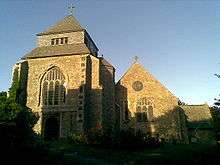 |
| The Abbey Gatehouse | Minster on Sea, Minster-on-Sea, Swale | Abbey | 13th century | 14 May 1952 | TQ9556572998 51°25′20″N 0°48′41″E / 51.422246°N 0.811417°E |
1258332 |  |
| Church of St Mary | Newington, Swale | Parish Church | 13th century | 24 January 1967 | TQ8622965341 51°21′24″N 0°40′24″E / 51.356614°N 0.673286°E |
1069347 |  |
| Church of St Mary | Norton, Buckland and Stone, Swale | Manor House | 12th century to 14th century | 24 January 1967 | TQ9677661100 51°18′54″N 0°49′20″E / 51.314974°N 0.822231°E |
1069252 |  |
| Church of St Peter | Oare, Oare, Swale | Manor House | 13th century | 24 January 1967 | TR0078863323 51°20′01″N 0°52′52″E / 51.333537°N 0.880975°E |
1069126 |  |
| Church of St Nicholas | Rodmersham, Swale | Parish Church | 13th century | 24 January 1967 | TQ9259761809 51°19′22″N 0°45′46″E / 51.322771°N 0.762723°E |
1120902 |  |
| Church of St Mary | St Mary's Church, Selling, Swale | Parish Church | c. 1190 | 24 January 1967 | TR0378856834 51°16′27″N 0°55′13″E / 51.274199°N 0.920278°E |
1343628 |  |
| Copton Manor | North Street, Sheldwich, Swale | House | 18th century | 24 January 1967 | TR0170659022 51°17′41″N 0°53′30″E / 51.294588°N 0.891704°E |
1372896 |
|
| Lees Court | Lees Court, Sheldwich, Swale | Flats | 1952 | 27 August 1952 | TR0203656066 51°16′05″N 0°53′41″E / 51.267926°N 0.894761°E |
1363416 |
|
| Church of St Mary | Teynham, Swale | Parish Church | 13th century | 24 January 1967 | TQ9661463631 51°20′16″N 0°49′17″E / 51.337761°N 0.821305°E |
1069254 |  |
| Belmont, with Stable Courtyard and Pump | Belmont, Throwley, Swale | House | 1769 | 24 January 1967 | TQ9858656362 51°16′18″N 0°50′44″E / 51.271795°N 0.845536°E |
1343978 |  |
| Church of St Michael and All Angels | Throwley Forstal, Throwley, Swale | Statue | 1835 | 28 August 1986 | TQ9914455651 51°15′55″N 0°51′11″E / 51.265216°N 0.853129°E |
1343984 |  |
| Church of St Giles | Tonge, Swale | Parish Church | 12th century | 24 January 1967 | TQ9342464035 51°20′33″N 0°46′33″E / 51.342482°N 0.775785°E |
1322821 |  |
| Church of St John the Baptist | Tunstall, Swale | Manor House | 13th century | 24 January 1967 | TQ8959061899 51°19′29″N 0°43′11″E / 51.324588°N 0.719668°E |
1069356 |  |
| Tunstall House | Tunstall, Swale | House | Pre 1678 | 27 August 1952 | TQ8946161825 51°19′26″N 0°43′04″E / 51.323967°N 0.71778°E |
1069357 |  |
| Church of St Mary the Virgin | Upchurch, Swale | Parish Church | c. 1300 | 24 January 1967 | TQ8436867499 51°22′36″N 0°38′52″E / 51.376604°N 0.647706°E |
1343934 |  |
| Parish Church of the Holy Trinity | Milton Regis, Swale | Parish Church | 14th century | 10 September 1951 | TQ9088865394 51°21′20″N 0°44′25″E / 51.355545°N 0.740147°E |
1061036 |  |
| Shed Number 78 the Boat Store Building Number 78 | Sheerness Dockyard, Swale | Boat Store | 1856-1860 | 21 June 1962 | TQ9088875297 51°26′40″N 0°44′44″E / 51.444487°N 0.74547°E |
1273160 |  |
Notes
- ↑ The date given is the date used by Historic England as significant for the initial building or that of an important part in the structure's description.
- ↑ Sometimes known as OSGB36, the grid reference is based on the British national grid reference system used by the Ordnance Survey.
- ↑ The "List Entry Number" is a unique number assigned to each listed building and scheduled monument by Historic England.
External links
![]() Media related to Grade I listed buildings in Swale at Wikimedia Commons
Media related to Grade I listed buildings in Swale at Wikimedia Commons
This article is issued from Wikipedia - version of the 8/25/2016. The text is available under the Creative Commons Attribution/Share Alike but additional terms may apply for the media files.