Grade I listed buildings in Craven

There are over 9,000 Grade I listed buildings in England. This page is a list of these buildings in the district of Craven in North Yorkshire.

List of buildings

Name Location Type Completed [note 1]Date designated Grid ref.[note 2]
Geo-coordinates
Notes Entry number [note 3]ImageRef.
Barden Church Barden Chapel 16th century 10 September 1954 SE0511857171
54°00′38″N 1°55′24″W / 54.010532°N 1.923394°W / 54.010532; -1.923394 (Barden Church)
1131761 [1]
Barden Tower Barden Tower house Mid-16th century 10 September 1954 SE0509357198
54°00′39″N 1°55′26″W / 54.010775°N 1.923775°W / 54.010775; -1.923775 (Barden Tower)
Tower house built by Henry Clifford, 17th century remodelling by Lady Anne Clifford 1317012
[2][3]
Barden Tower Farmhouse Barden House 16th century 10 September 1954 SE0511057163
54°00′38″N 1°55′25″W / 54.01046°N 1.923517°W / 54.01046; -1.923517 (Barden Tower Farmhouse)
1317013
[4]
Beamsley Hospital (north range) Beamsley Chapel 17th century 10 September 1954 SE0822953089
53°58′26″N 1°52′34″W / 53.973805°N 1.876032°W / 53.973805; -1.876032 (Beamsley Hospital (north range))
Hospital and chapel. Chapel built by Lady Margaret Russell 1131765
[5]
Church of St Mary, Bolton Abbey Bolton Abbey (village) Church Late 12th century 10 September 1954 SE0739854203
53°59′02″N 1°53′19″W / 53.983829°N 1.888675°W / 53.983829; -1.888675 (Church of St Mary, Bolton Abbey)
1166745
[1][6]
Priory of St Mary Bolton Abbey (village) Augustinian monastery 12th century 10 September 1954 SE0741754182
53°59′01″N 1°53′18″W / 53.98364°N 1.888386°W / 53.98364; -1.888386 (Priory of St Mary)
Scheduled ancient monument No 610 1131775
[7]
Broughton Hall Broughton Country house 1597 10 September 1954 SD9428250844
53°57′13″N 2°05′19″W / 53.953658°N 2.08862°W / 53.953658; -2.08862 (Broughton Hall)
1132296
[8]
Church of All Saints Broughton Church Early 16th century 10 September 1954 SD9340650359
53°56′57″N 2°06′07″W / 53.949288°N 2.101958°W / 53.949288; -2.101958 (Church of All Saints)
1132291
[8]
Church of St Wilfrid Burnsall Church 14th century 10 September 1954 SE0325761515
54°02′59″N 1°57′06″W / 54.049589°N 1.951746°W / 54.049589; -1.951746 (Church of St Wilfrid)
1131740
Farnhill Hall Main Street, Farnhill Fortified manor house 15th century 10 September 1954 SE0032946468
53°54′52″N 1°59′47″W / 53.91436°N 1.996477°W / 53.91436; -1.996477 (Farnhill Hall)
15th century substantially altered 16th and 19th century 1316997 [8]
Church of St Alkeda Giggleswick Church Late 14th/early 15th century 20 February 1958 SD8115164084
54°04′20″N 2°17′22″W / 54.072338°N 2.289538°W / 54.072338; -2.289538 (Church of St Alkeda)
Late 14th century to early 15th century and tower from the mid 15th century 1157303
[8]
Church of St Oswald Horton in Ribblesdale Parish church 12th century 20 February 1958 SD8101072116
54°08′40″N 2°17′32″W / 54.144519°N 2.2922°W / 54.144519; -2.2922 (Church of St Oswald)
1132264
Church of St Andrew Kildwick Church 14th century 10 September 1954 SE0114445893
53°54′33″N 1°59′03″W / 53.909192°N 1.984072°W / 53.909192; -1.984072 (Church of St Andrew)
1132175
[8][9]
Kildwick Bridge Kildwick Bridge 1305–13 10 September 1954 SE0111545699
53°54′27″N 1°59′04″W / 53.907448°N 1.984514°W / 53.907448; -1.984514 (Kildwick Bridge)
1167718
[8]
Church of St Michael the Archangel Kirkby Malham Parish church Late 15th century 20 February 1958 SD8940360997
54°02′41″N 2°09′48″W / 54.044831°N 2.163325°W / 54.044831; -2.163325 (Church of St Michael the Archangel)
1132389
Lawkland Hall and garden walls Lawkland House Late 16th century 20 February 1958 SD7765065922
54°05′19″N 2°20′35″W / 54.088716°N 2.343174°W / 54.088716; -2.343174 (Lawkland Hall and garden walls)
West wing late 16th century, extended late 17th century including hall and east wing 1132378
[8]
Church of St Mary the Virgin Long Preston Church Late 14th/early 15th century 20 February 1958 SD8371558090
54°01′07″N 2°15′00″W / 54.018555°N 2.250032°W / 54.018555; -2.250032 (Church of St Mary the Virgin)
1157818
The Folly Victoria Street, Settle House 1670s 20 February 1958 SD8207563568
54°04′04″N 2°16′31″W / 54.067734°N 2.275387°W / 54.067734; -2.275387 (The Folly)
Architect Richard Preston 1166834
[8]
Church of the Holy Trinity High Street, Skipton Church 14th century 28 April 1952 SD9903951914
53°57′48″N 2°00′58″W / 53.963307°N 2.016135°W / 53.963307; -2.016135 (Church of the Holy Trinity)
1131877
[8]
Former chapel at Skipton Castle The Bailey, Skipton Chapel Probably 13th century 28 April 1952 SD9904051982
53°57′50″N 2°00′58″W / 53.963918°N 2.01612°W / 53.963918; -2.01612 (Former chapel at Skipton Castle)
Former chapel that, when in use, was dedicated to St. John the Evangelist. Freestanding rectangular building within the Bailey of the Castle. 1131902
[8][10][11]
Outer gatehouse to Skipton Castle The Bailey, Skipton Gatehouse 14th century 28 April 1952 SD9908651931
53°57′48″N 2°00′56″W / 53.96346°N 2.015419°W / 53.96346; -2.015419 (Outer gatehouse to Skipton Castle)
This is the public entrance to the castle 1131901
[8]
Skipton Castle The Bailey, Skipton Castle Mostly early 14th century 28 April 1952 SD9911651998
53°57′51″N 2°00′54″W / 53.964062°N 2.014962°W / 53.964062; -2.014962 (Skipton Castle)
1316962
[8]
Church of St Mary Thornton in Craven Church Early 16th century 10 September 1954 SD9016148345
53°55′52″N 2°09′05″W / 53.931135°N 2.151335°W / 53.931135; -2.151335 (Church of St Mary)
1167634

See also

Notes

  1. The date given is the date used by Historic England as significant for the initial building or that of an important part in the structure's description.
  2. Sometimes known as OSGB36, the grid reference is based on the British national grid reference system used by the Ordnance Survey.
  3. The "List Entry Number" is a unique number assigned to each listed building and scheduled monument by Historic England.

References

  1. 1 2 Historic England. "Details from image database (323685)". Images of England. Retrieved 16 January 2009.
  2. "Barden Tower". English heritage: Pastscape. Retrieved 15 January 2009.
  3. Historic England. "Details from image database (323684)". Images of England. Retrieved 16 January 2009.
  4. Historic England. "Details from image database (323686)". Images of England. Retrieved 16 January 2009.
  5. Historic England. "Details from image database (323698)". Images of England. Retrieved 16 January 2009.
  6. "Church of St Mary". English heritage: Pastscape. Retrieved 15 January 2009.
  7. Historic England. "Details from image database (323723)". Images of England. Retrieved 16 January 2009.
  8. 1 2 3 4 5 6 7 8 9 10 11 12 "Listed Buildings in Craven District Outside YDNP" (pdf). Craven District Council. 28 April 2008. Retrieved 15 January 2009.
  9. Davies, Caroline (16 March 2008). "Parishes at war over plans to rip out pews: Archers-style rifts arise as vicars try to create space for concerts and yoga". The Observer from the guardian.co.uk site. Retrieved 15 January 2009.
  10. Historic England. "Details from image database (323418)". Images of England.
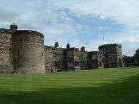
  11. "3D Castle Plan". Skiptobn Castle. 28 April 2008. Retrieved 17 January 2009.

Media related to Grade I listed buildings in Craven at Wikimedia Commons

This article is issued from Wikipedia - version of the 9/14/2016. The text is available under the Creative Commons Attribution/Share Alike but additional terms may apply for the media files.