Grade I listed buildings in Cheshire West and Chester
There are over 9,000 Grade I listed buildings in England. This page is a list of these buildings in the unitary authority of Cheshire West and Chester.
List of buildings
| Name | Location | Type | Completed [note 1] | Date designated | Grid ref.[note 2] Geo-coordinates | Notes | Entry number [note 3] | Image |
|---|---|---|---|---|---|---|---|---|
| Aldford Iron Bridge | Aldford | Bridge | 1824 | 4 June 1952 | SJ4182960087 53°08′05″N 2°52′16″W / 53.13480°N 2.87111°W |
A bridge designed by Thomas Telford and built by William Hazledine for the 1st Marquis of Westminster. It is built in cast iron and has yellow sandstone abutments forming a single arch. There are cast iron railings, and double gates at the crown of the bridge.[1][2] | 1129943 | 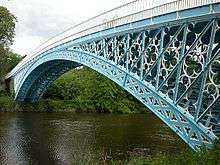 |
| St Peter's Church | Aston-by-Sutton | Church | 1695 | 8 January 1970 | SJ5558478464 53°18′04″N 2°40′04″W / 53.3012°N 2.6679°W |
The chancel dates from 1695, and the nave was built between in 1736 and 1740. The interior of the church was altered during the 19th and early 20th centuries, and the church was repaired in 1949–50 following damage by a land mine in 1940. The building is constructed in Runcorn sandstone, and is in Georgian style.[3][4][5][6] | 1138491 |  |
| Walls of the outer bailey at Beeston Castle | Beeston | Castle | c.1220 | 1 March 1967 | SJ5392159148 53°07′40″N 2°41′25″W / 53.12768°N 2.69015°W |
Built for Ranulf de Blondeville, 6th Earl of Chester, the sandstone castle was damaged in the Civil War. Remaining are the lower courses of the outer bailey. These include the remains of the towers and walls, with a gap at the site of the former gatehouse. The structure is under the care of English Heritage, and the whole site is a scheduled monument.[7][8][9] | 1130513 |  |
| Walls, towers and gatehouse of the inner bailey at Beeston Castle | Beeston | Castle | c.1220 | 1 March 1967 | SJ5370059266 53°07′43″N 2°41′37″W / 53.12854°N 2.69349°W |
Built for Ranulf de Blondeville, 6th Earl of Chester, the sandstone castle was damaged in the Civil War. Remaining are the gatehouse with its D-shaped towers, and parts of the curtain walls and its incorporated D-shaped towers. The structure is under the care of English Heritage, and the whole site is a scheduled monument.[7][8][10] | 1330329 |  |
| Lower Carden Hall | Carden | House | 15th century or earlier | 22 October 1952 | SJ4602252230 53°03′49″N 2°48′11″W / 53.0637°N 2.8030°W |
The hall was later enlarged and otherwise altered. It is basically timber-framed, with plaster panels on a sandstone plinth. The hall is in two storeys, with slate roofs and casement windows. There are large elaborate brick chimneystacks. In about 1984 the hall was restored, with a brick inner skin and steelwork.[11][12] | 1229918 |  |
| A Block | Chester Castle | Castle | Dated 1810 | 26 February 1985 | SJ4049265859 53°11′10″N 2°53′26″W / 53.186205°N 2.89065°W |
1271824 |  | |
| Agricola Tower | Chester Castle | Castle | Late 12th or early 13th century | 26 February 1985 | SJ4048265740 53°11′06″N 2°53′27″W / 53.185134°N 2.890777°W |
1271825 |  | |
| Assize Courts Block | Chester Castle | Prison | 1788–1801 | 1 June 1967 | SJ4050365795 53°11′08″N 2°53′26″W / 53.185631°N 2.890473°W |
1271823 |  | |
| B Block | Chester Castle | Gate | 1804 | 26 February 1985 | SJ4044665762 53°11′07″N 2°53′29″W / 53.185328°N 2.89132°W |
1245520 |  | |
| Curtain wall to west and south west of inner bailey, Chester Castle | Chester Castle | Wall | After 1246 | 1 June 1967 | SJ4043065741 53°11′06″N 2°53′30″W / 53.185137°N 2.891556°W |
1245537 | 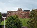 | |
| Propylaea | Chester Castle | Gate | 1811–13 | 1 June 1967 | SJ4040365841 53°11′10″N 2°53′31″W / 53.186033°N 2.891978°W |
1271822 |  | |
| St Edith's Church | Church Shocklach | Church | c. 1150 | 1 March 1967 | SJ4318050180 53°02′45″N 2°50′56″W / 53.0459°N 2.8490°W |
This is one of the oldest ecclesiastical buildings in Cheshire, and has a Norman doorway. The chancel and chancel arch date from the early 14th century, the ceiling was added in 1813 and the belfry was built in 1815. During a restoration in 1974 a semicircular window was added to the west wall.[13][14][15][16] | 1228322 |  |
| Eaton Chapel north of Eaton Hall | Eaton Park, Eaton | Chapel | 1873–84 | 2 November 1983 | SJ4139160776 53°08′27″N 2°52′39″W / 53.14092°N 2.87761°W |
A private chapel, with a clock tower, designed by Alfred Waterhouse for the 1st Duke of Westminster. It is built in sandstone with a slate roof, and consists of a nave and an apsed chancel. Inside is a gallery over a narthex, mosaics, an effigy of Constance, Duchess of Westminster, by Joseph Boehm, marble fittings and furniture, and stained glass.[17][18] | 1330615 | 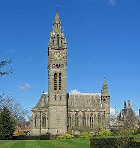 |
| Golden Gates and overthrow, screens and pair of wing lodges at Eaton Hall | Eaton Park, Eaton | Gate | Early 18th century | 4 June 1952 | SJ4128860722 53°08′25″N 2°52′45″W / 53.14040°N 2.87916°W |
The central pair of gates and the adjacent screen railings are by Robert and John Davies of Croes Foel. In about 1880 further side gates and screens, and a pair of lodges were added, all of which were designed by Alfred Waterhouse. The gates and screens are in wrought iron, and are painted black and gold. The lodges are in stone, they are in French Renaissance style, and each consists of a single chamber.[19][20] | 1136138 |  |
| Church of St Mary | Eccleston | Church | 1899 | 1 June 1967 | SJ4129062632 53°09′26″N 2°52′41″W / 53.157286°N 2.878115°W |
1138410 |  | |
| Farndon Bridge | Farndon | Bridge | 1339 | 1 March 1967 | SJ4117354412 53°05′01″N 2°52′47″W / 53.08365°N 2.87972°W |
The road bridge crosses the River Dee between the villages of Farndon and Holt, and is partly in Wales. It is constructed in sandstone, and consists of eight arches, five of which are cross the river. The bridge is also a scheduled monument.[21][22][23][24] | 1279428 |  |
| Church of St Lawrence | Frodsham | Church | Late 12th century | 8 January 1970 | SJ5212277293 53°17′26″N 2°43′11″W / 53.2905°N 2.7196°W |
The parish church of Frodsham stands in an elevated position to the east of the centre of the town. A church has been present on the site since the late 11th century. The fabric of the present church dates from the late 12th century, and its interior has arcades containing Norman material. The tower dates from the 14th century. In the 1880s there was some rebuilding of the interior by Bodley and Garner.[25][26] | 1253193 | 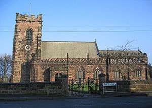 |
| Belmont Hall | Great Budworth | Country house | 1775 | 4 March 1969 | SJ6548578340 53°18′04″N 2°31′11″W / 53.3011°N 2.5198°W |
Designed as a country house, and designed by James Gibbs, although changes were made to the design during construction. It is built in brown brick and has a slate roof. The entrance façade is symmetrical with seven bays and three storeys. Internally there is fine plaster decoration in Rococo style. As of 2013 the building is occupied by Cransley School.[27][28][29] | 1139129 |  |
| St Mary and All Saints' Church | Great Budworth | Church | 14th century | 8 January 1970 | SJ6648577523 53°17′37″N 2°30′16″W / 53.2936°N 2.5044°W |
The oldest part of the church is the Lady chapel, dating from the 14th century, with the rest of the church being built in the following two centuries. Alterations were carried out during the 19th century by various architects, including Anthony Salvin, William Butterfield and John Douglas, when the church's major benefactor was Rowland Egerton-Warburton of Arley Hall. It is constructed in sandstone, and its architectural style is Perpendicular.[30][31][32] | 1139156 |  |
| Ince Manor | Ince | House | Late 13th century | 26 September 1963 | SJ4493376548 53°16′59″N 2°49′38″W / 53.2831°N 2.8271°W |
This consists of a group of buildings which were formerly a monastic grange. The remaining buildings are in two blocks, the old hall (pictured) and the monastic cottages, forming two sides of a courtyard. They are built in sandstone. The hall has an arched doorway, and mullioned and transomed windows. The cottages had become derelict towards the end of the 20th century, but have been restored. They have rectangular doorways and windows. The former grange is also a scheduled monument.[33][34][35] | 1138810 |  |
| Church of St Oswald | Malpas | Church | Late 14th century | 1 March 1967 | SJ4864447189 53°01′09″N 2°45′56″W / 53.019225°N 2.765666°W |
1135959 |  | |
| St Peter's Church | Plemstall, Mickle Trafford | Church | 15th century | 1 June 1967 | SJ4571070092 53°13′30″N 2°48′53″W / 53.2251°N 2.8147°W |
The church stands in an isolated position, and is built in sandstone with slate roofs. It is in Perpendicular style. The tower, with its embattled parapet, and crocketed finials, was added in 1826. The church consists of a nave and chancel in one range, a north aisle, a south porch, and a west tower. Many of the furnishings inside the church were carved by a former incumbent.[36][37] | 1279021 | 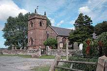 |
| St Oswald's Church | Lower Peover | Church | Late 14th century | 3 January 1967 | SJ7432174167 53°15′50″N 2°23′11″W / 53.2639°N 2.3864°W |
The nave and chancel date probably from the late 14th and 15th centuries, the west tower was added in 1582, and the aisles were altered and re-roofed in 1852 by Anthony Salvin. The body of the church is timber-framed, and the tower is in sandstone.[38][39] | 1139104 | 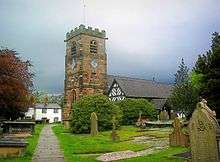 |
| St Helen's Church | Northwich | Church | 14th century | 24 March 1950 | SJ6643673805 53°15′37″N 2°30′17″W / 53.2602°N 2.5046°W |
Additions were made in the 15th and 16th centuries. During the 19th century there was a series of restorations, the last in 1883–86 when Paley and Austin also widened the north aisle, added a vestry and created a baptistry. The church is constructed in sandstone. It has a west tower and a canted east end.[40][41][42] | 1329880 |  |
| Winnington Hall | Northwich | Country house | c. 1600 | 24 March 1950 | SJ6450574749 53°16′07″N 2°32′01″W / 53.2686°N 2.5336°W |
This originated as a timber-framed country house. An additional stone wing was added in 1775 by Samuel Wyatt. During the 19th century it was used as a school, until in 1872 it was bought by Sir John Brunner and Ludwig Mond who each lived in a wing. After the First World War it was converted into a club for the use of the workers at the local chemical works, and has since has been made into offices.[43][44][45][46][47] | 1310245 | 
|
| Abbey Gate College Gatehouse | Saighton | Gateway | 1490 | 1 June 1967 | SJ4430761793 53°09′00″N 2°49′58″W / 53.150069°N 2.83285°W |
1138394 |
| |
| Church of St Michael | Shotwick | Church | Late 11th century | 1 June 1967 | SJ3367971771 53°14′19″N 2°59′38″W / 53.238539°N 2.993833°W |
1145903 |  | |
| Sutton Hall | Sutton | House | 15th century | 8 January 1970 | SJ5448679081 53°18′24″N 2°41′04″W / 53.3067°N 2.6844°W |
The hall was extended later. Externally it is constructed in brown brick. The hall has two storeys and attics, and contains timber-framed medieval halls that were encased in brick in the 18th century.[48][49] | 1253572 |
|
| Church of St Andrew | Tarvin | Church | Late 14th century | 1 March 1967 | SJ4918966963 53°11′49″N 2°45′38″W / 53.197031°N 2.760672°W |
1330302 |  | |
| Church of St Mary | Thornton-le-Moors | Church | 14th century onwards | 1 June 1967 | SJ4415774550 53°15′53″N 2°50′14″W / 53.264725°N 2.837325°W |
1330242 | .JPG) | |
| Chapel of St Chad | Tushingham cum Grindley | Chapel of ease | 1689–91 | 1 March 1967 | SJ5275046283 53°00′41″N 2°42′16″W / 53.011459°N 2.704323°W |
1130605 |  | |
| Utkinton Hall | Utkinton | Farmhouse | Medieval | 10 March 1953 | SJ5532664616 53°10′37″N 2°40′14″W / 53.1769°N 2.6705°W |
This former manor house has a medieval core, but most of the present house dates from the 17th and 18th centuries, since when it has been reduced in size. What remains is an L-shaped building in sandstone and brick, with slate roofs. It includes a row of four gables, one of which is timber-framed.[50][51] | 1329835 |
|
| St Mary's Church | Weaverham | Church | Mid-15th century | 3 January 1967 | SJ6169174237 53°15′50″N 2°34′33″W / 53.2638°N 2.5758°W |
A church has been present on the site since before the Norman conquest. The oldest part of the present church is the tower, with the rest dating from the 16th century. It was restored in 1855 by Anthony Salvin, and in 1877 by John Douglas. Its style is late Perpendicular. The font consists of a 13th-century column carrying a bowl from the 14th or 15th century, and a Jacobean cover.[52][53][54] | 1287233 |  |
| Abbey Gateway | Chester | Gatehouse | c.1300 | 28 July 1955 | SJ4050266487 53°11′31″N 2°53′26″W / 53.191851°N 2.890617°W |
1376366 |  | |
| Barnaby's Tower | Chester | Tower | Probably 13th century | 28 July 1955 | SJ4079465987 53°11′15″N 2°53′10″W / 53.187389°N 2.886154°W |
1376168 |  | |
| Bear and Billet Public House | Chester | Jettied house | 1664 | 28 July 1955 | SJ4064465831 53°11′09″N 2°53′18″W / 53.18597°N 2.88837°W |
1376318 |  | |
| Bonewaldesthorne Tower | Chester | Angle tower | 1249–61 | 28 July 1955 | SJ4003866552 53°11′33″N 2°53′51″W / 53.192383°N 2.897574°W |
1376128 |  | |
| Cathedral Church of Christ and the Blessed Virgin Mary | Chester | Cathedral | c.1100 | 28 July 1955 | SJ4060066446 53°11′29″N 2°53′21″W / 53.191493°N 2.889143°W |
1376398 |  | |
| Chester weir and salmon leap | River Dee, Chester | Weir | 1093 | 23 July 1998 | SJ4076765828 53°11′09″N 2°53′12″W / 53.185957°N 2.886529°W |
1375691 |  | |
| Church of St John the Baptist | Chester | Church | Late 11th century | 28 July 1955 | SJ4092266138 53°11′20″N 2°53′03″W / 53.188761°N 2.884267°W |
1375977 |  | |
| Church of St Peter | Chester | Church | 14th century onwards | 28 July 1955 | SJ4052666300 53°11′25″N 2°53′25″W / 53.190173°N 2.890223°W |
1376247 |  | |
| City Wall from Bonewaldesthorne Tower to Pemberton's Parlour | Chester | Wall | Late 11th–early 12th century | 28 July 1955 | SJ4012166578 53°11′33″N 2°53′47″W / 53.192626°N 2.896337°W |
1376130 |  | |
| Falcon Inn | Chester | Jettied house | 16th century | 28 July 1955 | SJ4056066060 53°11′17″N 2°53′23″W / 53.188019°N 2.88967°W |
1376292 |  | |
| Former monastic buildings to Cathedral Church of Christ and the Blessed Virgin | Chester | Abbey | Early 12th century | 28 July 1955 | SJ4058366490 53°11′31″N 2°53′22″W / 53.191887°N 2.889405°W |
1376397 |  | |
| Grosvenor Bridge | Chester | Road bridge | 1827–33 | 28 July 1955 | SJ4021665546 53°11′00″N 2°53′41″W / 53.18336°N 2.894722°W |
1375839 |  | |
| Kaleyard Gate | Chester | Town gate | c.1275 | 28 July 1955 | SJ4065866536 53°11′32″N 2°53′18″W / 53.192309°N 2.888291°W |
1376161 |  | |
| Morgan's Mount | Chester | Gun emplacement | 1640s | 28 July 1955 | SJ4024266626 53°11′35″N 2°53′40″W / 53.193071°N 2.894535°W |
1376134 |  | |
| Cowper House – Nos. 10 (Row) and 12 (Street), Bridge St. | Chester | Town house | 13th century | 28 July 1955 | SJ4050766244 53°11′23″N 2°53′26″W / 53.189667°N 2.890497°W |
1376063 |  | |
| Old Crypt – Nos. 11 (Street) and 15 and 15a (Row), Watergate St. | Chester | Town house | c.1300 | 18 July 1955 | SJ4047766256 53°11′23″N 2°53′27″W / 53.189772°N 2.890948°W |
1376424 |  | |
| Leche House – Nos. 17 (Street) and 21 (Row), Watergate St. | Chester | Galleried row house | Late 15th century | 28 July 1955 | SJ4046166250 53°11′23″N 2°53′28″W / 53.189716°N 2.891187°W |
1376427 |  | |
| Crypt Building – Nos. 28 (Street) and 34 (Row), Eastgate St. | Chester | Town house | c.1300 | 28 July 1955 | SJ4061166290 53°11′24″N 2°53′20″W / 53.190092°N 2.888949°W |
1376232 |  | |
| St Ursula's – Nos. 37 (Street) and 45 (Row), Watergate St. | Chester | Galleried row house | c.1180–1280 | 28 July 1955 | SJ4041466232 53°11′22″N 2°53′31″W / 53.189549°N 2.891887°W |
1376436 |  | |
| No. 39 Bridge Street | Chester | Bath house | 2nd century Roman | 28 July 1955 | SJ4056166172 53°11′20″N 2°53′23″W / 53.189026°N 2.889676°W |
1376085 | .JPG) | |
| Bishop Lloyd's House – No. 41 (Street) and 51 and 53 (Row), Watergate St. | Chester | Apartment | Medieval | 28 July 1955 | SJ4040066232 53°11′22″N 2°53′32″W / 53.189547°N 2.892096°W |
1376439 |  | |
| Three Old Arches – Nos. 48 and 50 (Street) and 48, 50 and 52 (Row), Bridge St. | Chester | Town house | c.1200 and later | 10 January 1972 | SJ4053566121 53°11′19″N 2°53′24″W / 53.188565°N 2.890055°W |
1376095 |  | |
| Blue Bell – Nos. 63 and 65, Northgate St. | Chester | Timber-framed house | Mid–late C15 | 28 July 1955 | SJ4042466617 53°11′35″N 2°53′31″W / 53.193011°N 2.891809°W |
1376358 |  | |
| Booth Mansion – Nos. 28–34 (Street) and 28 and 30 (Row), Watergate St. | Chester | Galleried row house | 1700 | 28 July 1955 | SJ4042966276 53°11′24″N 2°53′30″W / 53.189946°N 2.89167°W |
1376434 | 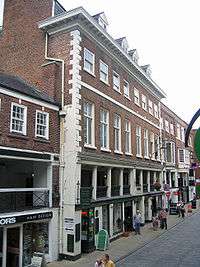 | |
| Old Dee Bridge | Chester | Road bridge | Late 14th century | 28 July 1955 | SJ4071765745 53°11′07″N 2°53′14″W / 53.185205°N 2.887262°W |
1375850 |  | |
| Part of City Wall between Morgan's Mount and Northgate | Chester | Wall | 1702–08 | 28 July 1955 | SJ4032566648 53°11′36″N 2°53′36″W / 53.193278°N 2.893296°W |
1376135 |  | |
| Part of City Wall from Barnaby's Tower to tower east of Bridgegate | Chester | Wall | 1702–08 | 28 July 1955 | SJ4076365917 53°11′12″N 2°53′12″W / 53.186756°N 2.886605°W |
1376169 |  | |
| Part of City Wall from County Hall (not included) to Grosvenor Road | Chester | Wall | Late 11th to early 12th century | 28 July 1955 | SJ4042965662 53°11′04″N 2°53′30″W / 53.184427°N 2.891556°W |
1376174 | 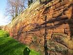 | |
| Part of City Wall from Eastgate to Thimbleby's Tower and attached gravestones | Chester | Wall | Late 1st to early 2nd century | 28 July 1955 | SJ4071666311 53°11′25″N 2°53′15″W / 53.190293°N 2.887382°W |
1376163 |  | |
| Part of City Wall from Grosvenor Road to the Watergate | Chester | Wall | 1702–08 | 28 July 1955 | SJ4026365841 53°11′10″N 2°53′39″W / 53.186017°N 2.894074°W |
1376175 |  | |
| Part of City Wall from Northgate to Phoenix Tower | Chester | Wall | 1702–08 | 28 July 1955 | SJ4050466699 53°11′38″N 2°53′26″W / 53.193757°N 2.890627°W |
1376136 | .jpg) | |
| Part of City Wall from Pemberton's Parlour to St Martin's Gate (not included) | Chester | Wall | 1702–08 | 28 July 1955 | SJ4017466596 53°11′34″N 2°53′44″W / 53.192794°N 2.895547°W |
1376132 |  | |
| Part of City Wall from Phoenix Tower to Kaleyard Gate | Chester | Wall | 1702–08 | 28 July 1955 | SJ4062166671 53°11′37″N 2°53′20″W / 53.193518°N 2.88887°W |
1376158 | .jpg) | |
| Part of City Wall from St Martin's Gate (not included) to Morgan's Mount | Chester | Wall | 1702–08 | 28 July 1955 | SJ4023166619 53°11′35″N 2°53′41″W / 53.193007°N 2.894698°W |
1376133 |  | |
| Part of City Wall from the Newgate to Barnaby's Tower | Chester | Wall | 1702–08 | 28 July 1955 | SJ4077066071 53°11′17″N 2°53′12″W / 53.188141°N 2.886529°W |
1376167 |  | |
| Part of City Wall from the Watergate to Bonewaldesthorne Tower | Chester | Wall | 1702–08 | 28 July 1955 | SJ4009366383 53°11′27″N 2°53′48″W / 53.19087°N 2.896719°W |
1376176 |  | |
| Part of City Wall from Thimbleby's Tower to Old Newgate | Chester | Wall | 1702–08 | 28 July 1955 | SJ4074966175 53°11′21″N 2°53′13″W / 53.189074°N 2.886863°W |
1376165 | | |
| Part of City Wall with tower base from Kaleyard Gate to Eastgate | Chester | Wall | 1702–08 | 28 July 1955 | SJ4066966492 53°11′31″N 2°53′17″W / 53.191914°N 2.888119°W |
1376162 |  | |
| Part of City Walls from Bridgegate to drum tower 50 metres east | Chester | Wall | 1702–08 | 28 July 1955 | SJ4070365842 53°11′10″N 2°53′15″W / 53.186075°N 2.887489°W |
1376172 |  | |
| Pemberton's Parlour (aka Goblin Tower) | Chester | Gate | After 1708 | 28 July 1955 | SJ4015366590 53°11′34″N 2°53′45″W / 53.192737°N 2.89586°W |
1376131 |  | |
| Phoenix Tower (aka King Charles' Tower) | Chester | Angle tower | 13th century | 28 July 1955 | SJ4061066712 53°11′38″N 2°53′21″W / 53.193885°N 2.889043°W |
1376157 |  | |
| Recorder's Steps | Chester | Steps | 1820–22 | 28 July 1955 | SJ4077065921 53°11′12″N 2°53′11″W / 53.186793°N 2.886501°W |
1376170 |  | |
| Remains of Roman Amphitheatre | Chester | Amphitheatre | 2nd century Roman | 10 January 1972 | SJ4082366192 53°11′21″N 2°53′09″W / 53.189235°N 2.885758°W |
1375863 |  | |
| Roman shrine to Minerva | Chester | Shrine | Early 2nd century Roman | 28 July 1955 | SJ4066765613 53°11′02″N 2°53′17″W / 53.184013°N 2.887985°W |
1375783 |  | |
| South-east angle tower and wall of Roman legionary fortress | Chester | Angle tower | Late 1st–early 2nd century Roman | 10 January 1972 | SJ4075166165 53°11′20″N 2°53′13″W / 53.188984°N 2.886831°W |
1376166 | .jpg) | |
| Spur Wall and Water Tower | Chester | Tower | 1322–26 | 28 July 1955 | SJ3999766544 53°11′32″N 2°53′53″W / 53.192306°N 2.898186°W |
1376129 |  | |
| St Mary's Centre | Chester | Church | 14th century | 28 July 1955 | SJ4055365844 53°11′10″N 2°53′23″W / 53.186077°N 2.889734°W |
1376382 |  | |
| The Bridgegate | Chester | Archway | 1781–82 | 28 July 1955 | SJ4067565829 53°11′09″N 2°53′16″W / 53.185955°N 2.887906°W |
1376320 |  | |
| The Eastgate and Clock | Chester | Archway | 1768–69 | 28 July 1955 | SJ4071166343 53°11′26″N 2°53′15″W / 53.19058°N 2.887462°W |
1376249 |  | |
| The Northgate | Chester | Archway | 1810 | 28 July 1955 | SJ4041166674 53°11′37″N 2°53′31″W / 53.193522°N 2.892014°W |
1376370 | .jpg) | |
| The Watergate | Chester | Archway | 1857 | 28 July 1955 | SJ4013766184 53°11′21″N 2°53′46″W / 53.189086°N 2.896023°W |
1376468 |  | |
| Thimbleby's Tower | Chester | Angle tower | 13th century | 28 July 1955 | SJ4075166183 53°11′21″N 2°53′13″W / 53.189146°N 2.886834°W |
1376164 |  | |
| Unnamed drum tower 50 metres east of the Bridgegate | Chester | Tower | 1702–08 | 28 July 1955 | SJ4071365846 53°11′10″N 2°53′14″W / 53.186113°N 2.88734°W |
1376171 |  |
Notes
- ↑ The date given is the date used by Historic England as significant for the initial building or that of an important part in the structure's description.
- ↑ Sometimes known as OSGB36, the grid reference is based on the British national grid reference system used by the Ordnance Survey.
- ↑ The "List Entry Number" is a unique number assigned to each listed building and scheduled monument by Historic England.
See also
- Grade I listed buildings in Cheshire
- Grade I listed buildings in Cheshire West and Chester
- Grade I listed buildings in Cheshire East
- Grade I listed buildings in Warrington
- Grade I listed buildings in Halton (borough)
- Grade II* listed buildings in Cheshire West and Chester
References
Citations
- ↑ Hartwell et al. (2011), p. 95
- ↑ Historic England, "Iron Bridge over the River Dee, Aldford (1129943)", National Heritage List for England, retrieved 17 March 2013
- ↑ Hartwell et al. (2011), pp. 115–116
- ↑ Richards (1950), pp. 115–135
- ↑ Starkey (1990), p. 60
- ↑ Historic England, "Church of St Peter, Aston (1138491)", National Heritage List for England, retrieved 1 January 2013
- 1 2 Hartwell et al. (2011), pp. 127–128
- 1 2 Historic England, "Beeston Castle; medieval enclosure castle and site of late prehistoric hillfort (1007900)", National Heritage List for England, retrieved 25 March 2013
- ↑ Historic England, "Walls of the Outer Bailey at Beeston Castle (1130513)", National Heritage List for England, retrieved 25 March 2013
- ↑ Historic England, "Walls, towers and gatehouse of the Inner Bailey at Beeston Castle (1330329)", National Heritage List for England, retrieved 25 March 2013
- ↑ Hartwell et al. (2011), p. 203
- ↑ Historic England, "Lower Carden Hall (1229918)", National Heritage List for England, retrieved 10 April 2013
- ↑ Hartwell, Claire; Hyde, Matthew; Hubbard, Edward; Pevsner, Nikolaus (2011) [1971], Cheshire, The Buildings of England, New Haven and London: Yale University Press, pp. 582–583, ISBN 978-0-300-17043-6
- ↑ Richards (1947), pp. 145–146
- ↑ Hodgson, Rev. Edward E., St Edith's Church, Shocklach, St Edith's Church, Shocklach
- ↑ Historic England, "Church of St Edith, Church Shocklach (1228322)", National Heritage List for England, retrieved 15 May 2013
- ↑ Hartwell et al. (2011), pp. 347–348
- ↑ Historic England, "Eaton Chapel north of Eaton Hall, Eaton (1330615)", National Heritage List for England, retrieved 3 June 2013
- ↑ Hartwell et al. (2011), p. 349
- ↑ Historic England, "Golden Gates and Overthrow, screens, and pair of wing lodges, Eaton (1136138)", National Heritage List for England, retrieved 1 June 2013
- ↑ Hartwell et al. (2011), p. 359
- ↑ Ward, S. S, "A Survey of Holt-Farndon Medieval Bridge", Cheshire Past, Chester Archaeological Service, pp. 14–15, retrieved 29 March 2008
- ↑ Historic England, "Farndon Bridge (that part in Cheshire, a scheduled Ancient Monument) (1279428)", National Heritage List for England, retrieved 25 June 2013
- ↑ Historic England, "Farndon Holt Bridge (1006758)", National Heritage List for England, retrieved 25 June 2013
- ↑ Hartwell et al. 2011, pp. 361–362.
- ↑ Historic England, "Church of St Lawrence, Frodsham (1253193)", National Heritage List for England, retrieved 24 April 2012
- ↑ Hartwell et al. (2011), pp. 378–379
- ↑ Historic England, "Belmont Hall, Great Budworth (1139129)", National Heritage List for England, retrieved 12 January 2013
- ↑ Welcome, Cransley School, retrieved 12 January 2013
- ↑ Hartwell et al. (2011), pp. 375–377
- ↑ Historic England, "Church of St Mary and All Saints, Great Budworth (1139156)", National Heritage List for England, retrieved 12 January 2013
- ↑ A Brief History, St Mary and All Saints, Great Budworth, retrieved 12 January 2013
- ↑ Hartwell et al. (2011), pp. 414–415
- ↑ Historic England, "Manor House of Abbey of St Werburgh Chester, (including Old Hall and Monastery Cottages, Ince (1138810)", National Heritage List for England, retrieved 29 July 2013
- ↑ Historic England, "Ince Manor monastic grange and fishpond (1009635)", National Heritage List for England, retrieved 29 July 2013
- ↑ Hartwell et al. (2011), pp. 528–529
- ↑ Historic England, "Church of St Peter, Mickle Trafford (1279021)", National Heritage List for England, retrieved 4 August 2013
- ↑ Hartwell et al. (2011), pp. 438–439
- ↑ Historic England, "Church of St Oswald, Nether Peover (1139104)", National Heritage List for England, retrieved 24 February 2013
- ↑ Hartwell et al. (2011), pp. 512–513
- ↑ Richards (1947), pp. 360–364
- ↑ Historic England, "Church of St Helen, Northwich (1329880)", National Heritage List for England, retrieved 18 January 2013
- ↑ Hartwell et al. (2011), pp. 677–679
- ↑ de Figueiredo & Treuherz (1988), pp. 197–203
- ↑ Koss & 170, pp. 28–29
- ↑ Historic England, "Winnington Hall, Northwich (1310245)", National Heritage List for England, retrieved 18 January 2013
- ↑ Winnington Hall, Winnington Hall, retrieved 18 January 2013
- ↑ Hartwell et al. (2011), p. 617
- ↑ Historic England, "Sutton Hall (1253572)", National Heritage List for England, retrieved 31 December 2012
- ↑ Hartwell et al. (2011), pp. 645–646
- ↑ Historic England, "Utkinton Hall (1329835)", National Heritage List for England, retrieved 19 February 2013
- ↑ Hartwell et al. (2011), pp. 659–660
- ↑ Richards (1947), pp. 345–348
- ↑ Historic England, "Church of St Mary, Weaverham (1287233)", National Heritage List for England, retrieved 17 January 2013
Sources
- Hartwell, Claire; Hyde, Matthew; Hubbard, Edward; Pevsner, Nikolaus (2011) [1971], Cheshire, The Buildings of England, New Haven and London: Yale University Press, ISBN 978-0-300-17043-6
- Koss, Stephen E. (1970), Sir John Brunner: Radical Plutocrat 1842-1919, Cambridge University Press, ISBN 0-521-07906-3
- Richards, Raymond (1950), "The Lesser Chapels of Cheshire: The Church of St. Peter, Aston by Sutton", Transactions of the Lancashire and Cheshire Antiquarian Society: 115–135
- Starkey, H. F. (1990), Old Runcorn, Halton Borough Council
Notes
External links
![]() Media related to Grade I listed buildings in Cheshire at Wikimedia Commons
Media related to Grade I listed buildings in Cheshire at Wikimedia Commons
This article is issued from Wikipedia - version of the 9/3/2016. The text is available under the Creative Commons Attribution/Share Alike but additional terms may apply for the media files.