Grade II* listed buildings in Rochford (district)
There are over 20,000 Grade II* listed buildings in England. This page is a list of these buildings in the district of Rochford in Essex.
Rochford
| Name | Location | Type | Completed [note 1] | Date designated | Grid ref.[note 2] Geo-coordinates |
Entry number [note 3] | Image |
|---|---|---|---|---|---|---|---|
| Church of St Andrew | Ashingdon, Rochford | Church | 1020 | 27 July 1959 | TQ8658793601 51°36′37″N 0°41′36″E / 51.610317°N 0.693341°E |
1112648 |  |
| Church of All Saints | Barling Magna, Rochford | Parish Church | 12th century | 27 July 1959 | TQ9320489713 51°34′23″N 0°47′12″E / 51.57317°N 0.786647°E |
1365617 |  |
| Church of St Mary the Virgin | Little Wakering, Barling Magna, Rochford | Parish Church | 12th century | 27 July 1959 | TQ9345588326 51°33′38″N 0°47′22″E / 51.560628°N 0.789502°E |
1147397 | 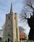 |
| Little Wakering Hall | Little Wakering, Barling Magna, Rochford | House | 16th century | 27 July 1959 | TQ9412788429 51°33′41″N 0°47′57″E / 51.561322°N 0.799241°E |
1147384 | 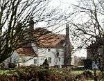 |
| Church of St Nicholas | Canewdon, Rochford | Parish Church | 14th century | 27 July 1959 | TQ8968894541 51°37′04″N 0°44′19″E / 51.617723°N 0.73858°E |
1147539 | 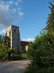 |
| Lambourne Hall | Canewdon, Rochford | Farmhouse | Late 13th century | 4 December 1951 | TQ9130994259 51°36′53″N 0°45′43″E / 51.614643°N 0.761812°E |
1308456 | 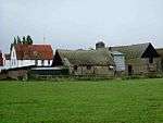 |
| Church of St Nicholas | Great Wakering, Rochford | Parish Church | c. 1100 | 27 July 1959 | TQ9496287562 51°33′12″N 0°48′39″E / 51.553248°N 0.810791°E |
1322393 |  |
| Church of St Mary the Virgin | Hawkwell, Rochford | Parish Church | 14th century | 27 July 1959 | TQ8602891862 51°35′42″N 0°41′04″E / 51.594883°N 0.684356°E |
1322323 |  |
| Church of St Peter and St Paul | Hockley, Rochford | Parish Church | Pre 12th century | 27 July 1959 | TQ8259593400 51°36′35″N 0°38′08″E / 51.609819°N 0.63565°E |
1112667 | 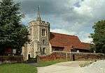 |
| Church of St Peter | Paglesham, Rochford | Parish Church | 12th century | 27 July 1959 | TQ9260593059 51°36′12″N 0°46′47″E / 51.603424°N 0.779849°E |
1112610 |  |
| Church of Holy Trinity | Rayleigh, Rochford | Parish Church | 12th century | 27 August 1957 | TQ8081490925 51°35′17″N 0°36′31″E / 51.588163°N 0.608682°E |
1112676 | 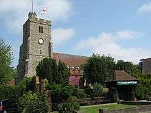 |
| Church of St Andrew | Rochford | Parish Church | Earlier | 27 July 1959 | TQ8718290283 51°34′49″N 0°42′01″E / 51.580319°N 0.700155°E |
1112585 |  |
| Purpose Built Barn with Horse Engine approx. 60 Metres South West of Doggetts Farmhouse and attached to Barn | Rochford | Horse Engine | EARLY/MID 19th century | 13 January 1988 | TQ8802491884 51°35′40″N 0°42′47″E / 51.594418°N 0.71315°E |
1322417 | 
|
| 17 South Street | Rochford | House | 1440 +/- 80 years | 27 July 1959 | TQ8766990410 51°34′53″N 0°42′26″E / 51.581298°N 0.707244°E |
1112559 |
|
| Church of St Mary and All Saints | Great Stambridge, Rochford | Parish Church | Pre-Conquest | 27 July 1959 | TQ8945490736 51°35′01″N 0°43′59″E / 51.583629°N 0.733151°E |
1168425 | 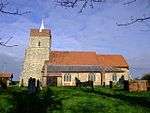 |
| Beauchamps | Sutton, Rochford | House | Later | 4 December 1951 | TQ9075288409 51°33′44″N 0°45′02″E / 51.562293°N 0.7506°E |
1112579 |  |
| Church of All Saints | Sutton, Rochford | Parish Church | C14/C15 | 27 July 1959 | TQ8878589231 51°34′13″N 0°43′22″E / 51.570337°N 0.722698°E |
1113355 |  |
Notes
- ↑ The date given is the date used by Historic England as significant for the initial building or that of an important part in the structure's description.
- ↑ Sometimes known as OSGB36, the grid reference is based on the British national grid reference system used by the Ordnance Survey.
- ↑ The "List Entry Number" is a unique number assigned to each listed building and scheduled monument by Historic England.
External links
![]() Media related to Grade II* listed buildings in Essex at Wikimedia Commons
Media related to Grade II* listed buildings in Essex at Wikimedia Commons
This article is issued from Wikipedia - version of the 9/10/2016. The text is available under the Creative Commons Attribution/Share Alike but additional terms may apply for the media files.