Grade II* listed buildings in Hinckley and Bosworth
There are over 20,000 Grade II* listed buildings in England. This page is a list of these buildings in Hinckley and Bosworth.
Hinckley and Bosworth
| Name | Location | Type | Completed [note 1] | Date designated | Grid ref.[note 2] Geo-coordinates |
Entry number [note 3] | Image |
|---|---|---|---|---|---|---|---|
| Church of St Catherine | Burbage, Hinckley and Bosworth | Parish Church | 1842 | 8 March 1963 | SP4427592747 52°31′51″N 1°20′56″W / 52.530799°N 1.348766°W |
1295212 |  |
| The Old Grange and Attached Stable Wing | Burbage, Hinckley and Bosworth | Kitchen | 1697 | 8 March 1963 | SP4440092657 52°31′48″N 1°20′49″W / 52.52998°N 1.346935°W |
1178068 | 
|
| Church of All Saints | Cadeby, Hinckley and Bosworth | Parish Church | Late 13th century | 7 November 1966 | SK4258302339 52°37′02″N 1°22′21″W / 52.617159°N 1.372477°W |
1074283 |  |
| Attached barn and service block, Old Manor House | Desford, Hinckley and Bosworth | Farmhouse | 19th century | 22 October 1952 | SK4789903334 52°37′32″N 1°17′38″W / 52.625661°N 1.293821°W |
1074078 |
|
| Church of St Martin | Desford, Hinckley and Bosworth | Parish Church | Late 13th century | 7 November 1966 | SK4786203469 52°37′37″N 1°17′40″W / 52.626878°N 1.294348°W |
1361378 |  |
| Church of St Simon and St Jude | Earl Shilton, Hinckley and Bosworth | Parish Church | 15th century | 8 March 1963 | SP4711698198 52°34′46″N 1°18′22″W / 52.579562°N 1.306117°W |
1074259 |  |
| Stables and kennels to Bradgate House | Groby, Hinckley and Bosworth | Kennels | 1856 | 29 November 1988 | SK5070209288 52°40′44″N 1°15′05″W / 52.678927°N 1.251503°W |
1361383 |
|
| Groby Old Hall | Groby, Hinckley and Bosworth | House | Late 15th century | 22 October 1952 | SK5238907574 52°39′48″N 1°13′37″W / 52.66336°N 1.226825°W |
1074083 |  |
| Church of St Peter | Higham on the Hill, Hinckley and Bosworth | Parish Church | 12th century | 7 November 1966 | SP3826795560 52°33′24″N 1°26′13″W / 52.55654°N 1.437002°W |
1178178 |  |
| Bosworth Hall | Market Bosworth, Hinckley and Bosworth | Country House Hotel | c1680-90 | 28 May 1987 | SK4083803332 52°37′34″N 1°23′53″W / 52.626219°N 1.398127°W |
1251547 |  |
| Church of St Peter | Market Bosworth, Hinckley and Bosworth | Parish Church | 13th century | 7 November 1966 | SK4074703260 52°37′32″N 1°23′58″W / 52.625578°N 1.39948°W |
1307453 |  |
| The Dower House | Market Bosworth, Hinckley and Bosworth | House | Early 18th century | 3 August 1970 | SK4060403237 52°37′31″N 1°24′06″W / 52.625382°N 1.401595°W |
1361288 |
|
| Church of St Michael | Markfield, Hinckley and Bosworth | Parish Church | C12-C14 | 7 November 1966 | SK4870510039 52°41′09″N 1°16′51″W / 52.685861°N 1.280927°W |
1320243 |  |
| Church of All Saints | Nailstone, Hinckley and Bosworth | Parish Church | Late 14th century | 7 November 1966 | SK4180507143 52°39′37″N 1°23′00″W / 52.660403°N 1.38336°W |
1361277 | .jpg) |
| Osbaston Hall | Osbaston, Hinckley and Bosworth | Country House | Late 16th century | 7 November 1966 | SK4237504512 52°38′12″N 1°22′31″W / 52.636709°N 1.375271°W |
1361278 |  |
| Church of All Saints | Kirkby Mallory, Peckleton, Hinckley and Bosworth | Parish Church | Early 14th century | 7 November 1966 | SK4540800344 52°35′56″N 1°19′52″W / 52.598997°N 1.331027°W |
1074237 |  |
| Church of St Martin | Stapleton, Peckleton, Hinckley and Bosworth | Church | Early 14th century | 7 November 1966 | SP4347198451 52°34′56″N 1°21′36″W / 52.582139°N 1.359871°W |
1074234 |  |
| Church of St Philip and St James | Ratby, Hinckley and Bosworth | Parish Church | C13,C14,C15 | 7 November 1966 | SK5131105963 52°38′56″N 1°14′35″W / 52.648982°N 1.243012°W |
1074093 |  |
| Church of St Mary the Virgin | Congerstone, Shackerstone, Hinckley and Bosworth | Parish Church | 16th century | 7 November 1966 | SK3669705447 52°38′44″N 1°27′33″W / 52.645526°N 1.459065°W |
1074210 |  |
| Church of St Peter | Shackerstone, Hinckley and Bosworth | Parish Church | Late 15th century | 7 November 1966 | SK3741306737 52°39′25″N 1°26′54″W / 52.657074°N 1.448337°W |
1188168 | 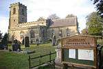 |
| Help-out Mill | Odstone, Shackerstone, Hinckley and Bosworth | Mill House | Early 19th century | 10 January 1973 | SK3791507811 52°40′00″N 1°26′27″W / 52.666693°N 1.440793°W |
1188178 | .jpg) |
| Church of All Saints | Sheepy Magna, Sheepy, Hinckley and Bosworth | Parish Church | 15th century | 11 June 1966 | SK3261201321 52°36′31″N 1°31′11″W / 52.608696°N 1.519843°W |
1177853 |  |
| Church of St Botolph | Sibson, Sheepy, Hinckley and Bosworth | Church | Late C13-early 14th century | 7 November 1966 | SK3541500910 52°36′17″N 1°28′43″W / 52.604826°N 1.478496°W |
1177977 |  |
| The Great Barn at Newhouse Grange | Sheepy Magna, Sheepy, Hinckley and Bosworth | Aisled Barn | 14th century | 7 November 1966 | SK3176402349 52°37′05″N 1°31′56″W / 52.617987°N 1.532267°W |
1361280 |
|
| Church of St James | Sutton Cheney, Hinckley and Bosworth | Church | 1635 | 7 November 1966 | SK4164500471 52°36′02″N 1°23′12″W / 52.60044°N 1.386565°W |
1074245 |  |
| Church of St James | Dadlington, Sutton Cheney, Hinckley and Bosworth | Church | Late 13th century | 7 November 1966 | SP4036198064 52°34′44″N 1°24′21″W / 52.578899°N 1.405814°W |
1361304 |  |
| Church of St John the Evangelist | Shenton, Sutton Cheney, Hinckley and Bosworth | Parish Church | c. 1860 | 7 November 1966 | SK3867100336 52°35′58″N 1°25′50″W / 52.599445°N 1.430488°W |
1074247 | .jpg) |
| Shenton Hall | Shenton, Sutton Cheney, Hinckley and Bosworth | House | c. 1620 | 7 November 1966 | SK3873000297 52°35′57″N 1°25′47″W / 52.59909°N 1.429621°W |
1178135 |  |
| Dovecote at Shenton Hall | Shenton, Sutton Cheney, Hinckley and Bosworth | Dovecote | 1719 | 7 November 1966 | SK3867900291 52°35′57″N 1°25′49″W / 52.59904°N 1.430375°W |
1074248 |
|
| Gatehouse to Shenton Hall | Shenton, Sutton Cheney, Hinckley and Bosworth | Gatehouse | 1629 | 7 November 1966 | SK3871500331 52°35′58″N 1°25′47″W / 52.599397°N 1.429839°W |
1361305 |  |
| Hall Farmhouse | Sutton Cheney, Hinckley and Bosworth | Farmhouse | Early 17th century | 22 October 1952 | SK4182700516 52°36′03″N 1°23′02″W / 52.60083°N 1.383872°W |
1074243 |
|
| Church of the Holy Trinity | Norton Juxta Twycross, Twycross, Hinckley and Bosworth | Church | Early 14th century | 7 November 1966 | SK3228607066 52°39′37″N 1°31′27″W / 52.660359°N 1.524098°W |
1294757 |  |
| Church of All Saints | Ratcliffe Culey, Witherley, Hinckley and Bosworth | Church | Early 14th century | 7 November 1966 | SP3267699416 52°35′30″N 1°31′09″W / 52.591567°N 1.519086°W |
1188508 | .jpg) |
| Church of St Michael | Fenny Drayton, Witherley, Hinckley and Bosworth | Parish Church | 12th century | 7 November 1966 | SP3503897113 52°34′15″N 1°29′04″W / 52.570718°N 1.484463°W |
1361313 |  |
| Church of the Assumption of St Mary | Hinckley and Bosworth | Parish Church | Early 14th century | 8 March 1963 | SP4271393823 52°32′26″N 1°22′18″W / 52.540596°N 1.371652°W |
1361297 |  |
| The Great Meeting | Hinckley, Hinckley and Bosworth | Unitarian Chapel | 1722 | 8 March 1963 | SP4263494104 52°32′35″N 1°22′22″W / 52.543128°N 1.37278°W |
1295167 | |
Notes
- ↑ The date given is the date used by Historic England as significant for the initial building or that of an important part in the structure's description.
- ↑ Sometimes known as OSGB36, the grid reference is based on the British national grid reference system used by the Ordnance Survey.
- ↑ The "List Entry Number" is a unique number assigned to each listed building and scheduled monument by Historic England.
External links
![]() Media related to Grade II* listed buildings in Leicestershire at Wikimedia Commons
Media related to Grade II* listed buildings in Leicestershire at Wikimedia Commons
This article is issued from Wikipedia - version of the 8/25/2016. The text is available under the Creative Commons Attribution/Share Alike but additional terms may apply for the media files.