Georgia State Route 354
| ||||
|---|---|---|---|---|
 | ||||
| Route information | ||||
| Maintained by GDOT | ||||
| Length: | 6.9 mi[1] (11.1 km) | |||
| Existed: | 1963[2][3] – present | |||
| Major junctions | ||||
| South end: |
| |||
|
| ||||
| North end: |
| |||
| Location | ||||
| Counties: | Harris | |||
| Highway system | ||||
| ||||

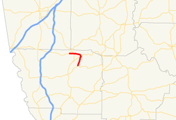
State Route 354 (SR 354) is a 6.9-mile-long (11.1 km), arc-shaped state highway located entirely within Harris County in the west-central part of the U.S. state of Georgia. It starts out in a north-northeasterly direction and curves to a westerly direction. This highway was built in the early 1960s, on the same alignment as it travels today.
Route description
SR 354 begins at an intersection with SR 116 in Pine Mountain Valley. It ascends the Pine Mountain ridge. the route travels to the north-northeast and enters F. D. Roosevelt State Park. On top of the mountain ridge, SR 190 passes over the route on a historic bridge built by the Civilian Conservation Corps. It begins to curve to the west and exits the park. SR 354 enters Pine Mountain, where it intersects US 27/SR 1 (Main Street). The route continues to the west until it meets its northern terminus, an intersection with SR 18 west of the town in Champion Crossroad. The route serves as a connector and access road for traffic visiting F. D. Roosevelt State Park.[1]
SR 354 is not part of the National Highway System, a system of roadways important to the nation's economy, defense, and mobility.[4]
History
SR 354 was built, and paved, on its current alignment between 1960 and 1963.[2][3]
Major intersections
The entire route is in Harris County.
| Location | mi[1] | km | Destinations | Notes | |
|---|---|---|---|---|---|
| Pine Mountain Valley | 0.0 | 0.0 | Southern terminus | ||
| F. D. Roosevelt State Park | 3.2 | 5.1 | |||
| Pine Mountain | 5.7 | 9.2 | |||
| Champion Crossroad | 6.9 | 11.1 | Northern terminus | ||
| 1.000 mi = 1.609 km; 1.000 km = 0.621 mi | |||||
See also
-
.svg.png) Georgia (U.S. state) portal
Georgia (U.S. state) portal -
 U.S. Roads portal
References
- 1 2 3 Google (November 3, 2013). "Route of SR 354" (Map). Google Maps. Google. Retrieved November 3, 2013.
- 1 2 Georgia State Highway System (PDF) (Map). Cartography by GSHD. Georgia State Highway Department. June 1, 1960. Retrieved August 16, 2015.
- 1 2 Georgia State Highway System (PDF) (Map). Cartography by GSHD. Georgia State Highway Department. June 1, 1963. Retrieved August 16, 2015.
- ↑ "National Highway System: Georgia" (PDF). Federal Highway Administration. October 1, 2012. Retrieved October 19, 2013.