Gaylord, Oregon
| Gaylord, Oregon | |
|---|---|
| Unincorporated community | |
 Gaylord  Gaylord Location within the state of Oregon | |
| Coordinates: 42°57′19″N 124°06′24″W / 42.95528°N 124.10667°WCoordinates: 42°57′19″N 124°06′24″W / 42.95528°N 124.10667°W | |
| Country | United States |
| State | Oregon |
| County | Coos |
| Elevation[1] | 85 ft (26 m) |
| Time zone | Pacific (PST) (UTC-8) |
| • Summer (DST) | PDT (UTC-7) |
| GNIS feature ID | 1142595 |
Gaylord is an unincorporated community in Coos County, Oregon, United States.[1] It is about 12 miles (19 km) south of Myrtle Point on Oregon Route 542, near the South Fork Coquille River.[2]
A station named Gaylord Siding was established on the Coos Bay Line of the Southern Pacific Railroad in 1916.[3][4] A post office named Gaylord was established nearby in 1927; it closed in 1958.[3] The source of the name is unknown.[3]
Author Ralph Friedman says of Gaylord that it is "Nothing but a name".[5]
References
- 1 2 "Gaylord". Geographic Names Information System (GNIS). United States Geological Survey. November 28, 1980. Retrieved May 6, 2016.
- ↑ Oregon Atlas & Gazetteer (7th ed.). Yarmouth, Maine: DeLorme. 2008. p. 52. ISBN 0-89933-347-8.
- 1 2 3 McArthur, Lewis A.; McArthur, Lewis L. (2003) [1928]. Oregon Geographic Names (7th ed.). Portland, Oregon: Oregon Historical Society Press. p. 396. ISBN 978-0875952772.
- ↑ Writers' Program of the Work Projects Administration in the State of Oregon (1940). Oregon: End of the Trail. American Guide Series. Portland, Oregon: Binfords & Mort. p. 357. OCLC 4874569.
- ↑ Friedman, Ralph (1990). In Search of Western Oregon (2nd ed.). Caldwell, Idaho: The Caxton Printers, Ltd. p. 229. ISBN 0-87004-332-3.
Municipalities and communities of Coos County, Oregon, United States | ||
|---|---|---|
| Cities | 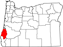 | |
| CDPs | ||
| Unincorporated communities | ||
| Ghost town | ||
This article is issued from Wikipedia - version of the 8/1/2016. The text is available under the Creative Commons Attribution/Share Alike but additional terms may apply for the media files.