Franks Field, Wisconsin
| Franks Field, Wisconsin | |
|---|---|
| Census-designated place | |
 Franks Field | |
| Coordinates: 46°33′08″N 90°35′56″W / 46.55222°N 90.59889°WCoordinates: 46°33′08″N 90°35′56″W / 46.55222°N 90.59889°W | |
| Country | United States |
| State | Wisconsin |
| County | Ashland |
| Town | Sanborn |
| Area | |
| • Total | 1.266 sq mi (3.28 km2) |
| • Land | 1.266 sq mi (3.28 km2) |
| • Water | 0 sq mi (0 km2) |
| Elevation | 810 ft (250 m) |
| Population (2010)[1] | |
| • Total | 154 |
| • Density | 120/sq mi (47/km2) |
| Time zone | Central (CST) (UTC-6) |
| • Summer (DST) | CDT (UTC-5) |
| Area code(s) | 715 & 534 |
| GNIS feature ID | 2585063[2] |
Franks Field is a census-designated place in the town of Sanborn, Ashland County, Wisconsin, United States. Its population was 154 as of the 2010 census.[1] Franks Field is located on the Bad River Indian Reservation.
References
| Communities |  | |
|---|---|---|
| Related Geographic Aspects | ||
| Local Native American Tribes | ||
Municipalities and communities of Ashland County, Wisconsin, United States | ||
|---|---|---|
| Cities | 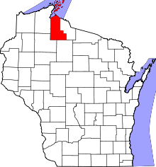 | |
| Village | ||
| Towns | ||
| CDPs | ||
| Unincorporated communities | ||
| Indian reservation | ||
| Footnotes | ‡This populated place also has portions in an adjacent county or counties | |
This article is issued from Wikipedia - version of the 3/23/2016. The text is available under the Creative Commons Attribution/Share Alike but additional terms may apply for the media files.