Fountainville, Pennsylvania
| Fountainville, Pennsylvania | |
|---|---|
| Unincorporated community | |
 Fountainville | |
| Coordinates: 40°20′28″N 75°9′2″W / 40.34111°N 75.15056°WCoordinates: 40°20′28″N 75°9′2″W / 40.34111°N 75.15056°W | |
| Country | United States |
| State | Pennsylvania |
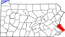
| County | Bucks |
| Township | Doylestown, New Britain, and Plumstead |
| Elevation | 407 ft (124 m) |
| Time zone | Eastern (EST) (UTC-5) |
| • Summer (DST) | EDT (UTC-4) |
| ZIP code | 18923 |
| Area code(s) | 215 and 267 |
| GNIS feature ID | 1203615[1] |
Fountainville is an unincorporated community in Bucks County, Pennsylvania, United States. Fountainville is located at the intersection of Pennsylvania Route 313 and Ferry Road at the tripoint of Doylestown, New Britain, and Plumstead townships.[2]
References
- ↑ "Fountainville". Geographic Names Information System. United States Geological Survey.
- ↑ Bucks County, Pennsylvania (Map) (19th ed.). 1"=2000'. ADC Map. 2006. p. 2922. § F6. ISBN 0-87530-774-4.
This article is issued from Wikipedia - version of the 9/1/2014. The text is available under the Creative Commons Attribution/Share Alike but additional terms may apply for the media files.