Fort William, Ontario
Fort William was a city in Northern Ontario, located on the Kaministiquia River, at its entrance to Lake Superior. It amalgamated with Port Arthur and the townships of Neebing and McIntyre to form the city of Thunder Bay in January 1970. Since then it has been the largest city in Northwestern Ontario. The city's Latin motto was A posse ad esse (From a Possibility to an Actuality) featured on its coat of arms designed in 1900 by town officials, "On one side of the shield stands an Indian dressed in the paint and feathers of the early days; on the other side is a French voyageur; the center contains an elevator, a steamship and a locomotive, while the beaver surmounts the whole." [1]
History
Fur Trade era
Fort William and Grand Portage were the two starting points for the canoe route from the Great Lakes to Western Canada. For details of the route inland see Kaministiquia River.
French period (Fort Kaministiquia)
Kamanistigouian, as a place, is first mentioned in a decree of the Conseil Souverain de la Nouvelle-France dated 23 August 1681 instructing one of two canoes to make known the king's amnesty to coureurs de bois, although the Kaministiquia River is depicted on the 1671 "Carte des Jésuites" as "R. [rivière] par où l'on va aux Assinipoualacs à 120 lieues vers le Nord-Ouest."[2] In late 1683 or spring 1684, Daniel Greysolon, Sieur du Lhut, established a trading post near the mouth of the Kaministiquia River. French authorities closed this post in 1696 because of a glut on the fur market. In 1717, a new post, Fort Kaministiquia, was established at the river mouth by Zacharie Robutel de la Noue. This post appears on 18th century French maps by Royal hydrographer Jacques-Nicolas Bellin as "Fort Caministogoyan". The post was abandoned in 1758 or 1760 during the British conquest of New France.
English period (Fort William)
The fur trade was quickly re-established with most people using Grand Portage. By 1784, Montreal merchants and their "wintering partners" had formed the North West Company (Nor'Westers). The North West Company continued to use Grand Portage as their centre of operations after the area was ceded to the United States after the colonists' victory in the American Revolution. Following the signing of the Jay Treaty of 1794 between Great Britain and the United States, which acknowledged American control of the area, the North West Company required a new midway transshipment point between their inland posts and Montreal. The partners needed to meet and exchange furs and supplies without being subject to American taxation.

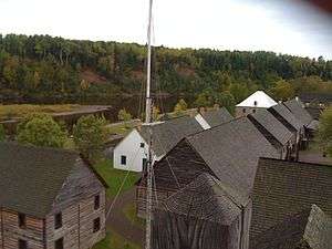
In 1803, the Nor'Westers abandoned Grand Portage and established a new fur trading post on the Kaministiquia River on land acquired from the Ojibwe by written agreement 30 July 1798.[3] The post was named Fort William in 1807 after William McGillivray, chief director of the North West Company from 1804-1821. After the union of the North West Company with the Hudson's Bay Company (HBC) in 1821, the fort lost its raison d'être because most trade shifted to York Factory on Hudson Bay. It became a minor HBC fur trading post. The original site disappeared under development of Canadian Pacific Railway railroad tracks and coal piles in the 1880s. A replica of Fort William was built further upstream on the Kaministiquia River at Point de Meuron, a former military staging location named after Lord Selkirk's Swiss de Meuron regiment. It is now known as the Fort William Historical Park.
19th century and after
Two townships (Neebing and Paipoonge) and the Fort William Town Plot were surveyed in 1859-60 by the Province of Canada's Department of Crown Lands and opened to settlement. A large section of land adjacent to the Hudson's Bay Company post remained in dispute until 1875, when it was surveyed as Neebing Additional Township. Most land was acquired by absentee landowners, with speculation built on the decision of the new Dominion of Canada to build a railway to the Pacific to begin somewhere along the north shore of Lake Superior. The selection of the Fort William Town Plot (later known as West Fort) as the eastern terminus for the CPR stimulated development, as did the construction of the railway begun in June 1875. The federal Department of Public Works, and later the Department of Railways and Canals, took seven years (1875–1882) to build the Thunder Bay Branch from Fort William to Winnipeg, Manitoba.[4]
The Ontario Legislature incorporated the Municipality of Shuniah in March 1873. This early form of regional government comprised a vast area from Sibley Peninsula to the American border. For eight years the residents of Neebing and Neebing Additional townships battled Port Arthur residents for the Thunder Bay terminus. In March 1881, the inhabitants of Neebing and Neebing Additional petitioned the Ontario Legislature successfully to separate the southern townships from Shuniah and to create the Municipality of Neebing.
By 1883-84, the Montreal-based CPR syndicate, in collaboration with the Hudson's Bay Company, clearly preferred the low-lying lands along the lower Kaministiquia River to the exposed shores of Port Arthur, which required an expensive breakwater if shipping and port facilities were to be protected from the waves. The CPR subsequently consolidated all its operations there, erecting rail yards, coal-handling facilities, grain elevators and a machine shop.[5] In April 1892, Neebing Additional Township and parts of Neebing Township were incorporated as the Town of Fort William. Fort William was incorporated as a city in April 1907. The City of Fort William ceased to exist at the end of December 1969.
Notable people
- Jack Adams, professional hockey player, coach and general manager.
- Gus Bodnar, professional hockey player.[6]
- Alex Delvecchio, professional hockey player.
See also
References
- ↑ Daily Times-Journal 11 Sept 1900 p. 1
- ↑ Pierre Margry, Découvertes et établissements des Français ... en Amérique septentrionale, (Paris, 1876-1886), VI, 4-6.
- ↑ "Joseph M. Mauro, A Golden Gateway of the Great Northwest - History of Thunder Bay, (Thunder Bay, Ont.,1981), 21-23
- ↑ F.B. Scollie, "How the Fort William Town Plot became Westfort", Thunder Bay Historical Museum Society Papers and Records, XVI (1988), 29-31.
- ↑ F.B. Scollie, "A Capsule Municipal History", in Thunder Bay Mayors & Councillors 1873-1945 (Thunder Bay, Ont.: Thunder Bay Historical Museum Society, 2000), 6-11.
- ↑ Oral History >Famous Ukrainian-Canadians
General
- Morrison, Jean F. (2007) [2001], Superior rendez-vous place : Fort William in the Canadian fur trade (book) (2nd ed. ed.), Toronto: Dundurn, ISBN 9781550027815, OCLC 47037457
- Morrison, Jean F., ed. Lake Superior to Rainy River : three centuries of fur trade history : a collection of writings. Thunder Bay, Ont. : Thunder Bay Historical Museum Society, 2003.
- Thunder Bay from rivalry to unity / edited by Thorold J. Tronrud and A. Ernest Epp. Thunder Bay : Thunder Bay Historical Museum Society, 1995.
External links
| Wikisource has the text of a 1911 Encyclopædia Britannica article about Fort William, Ontario. |
 "Fort William". Collier's New Encyclopedia. 1921.
Coordinates: 48°23′N 89°17′W / 48.38°N 89.28°W
