Fort Collins – Loveland Metropolitan Statistical Area
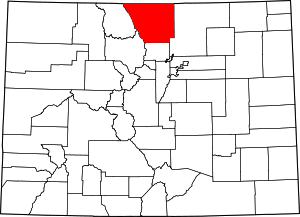
Map of the Fort Collins-Loveland Metropolitan Statistical Area
Main article: Colorado census statistical areas
See also: Colorado metropolitan areas
The Fort Collins-Loveland Metropolitan Statistical Area is a United States Office of Management and Budget (OMB) defined Metropolitan Statistical Area (MSA) located in the Fort Collins and Loveland area in the North Central region of the U.S. state of Colorado. The Fort Collins-Loveland MSA is defined as Larimer County, Colorado. The Census Bureau estimates that the population was 310,487 in 2012, an 3.62% increase since 2010. The Fort Collins-Loveland MSA is the 151st most populous MSA in the United States.[1]
Metropolitan Area Cities and Towns
| Place | Name | 2012 Population | Notes |
|---|---|---|---|
| 1 | FortCity of Fort Collins | 148,612 | |
| 2 | LoveCity of Loveland | 70,223 | |
| 3 | WellTown of Wellington | 6,514 | |
| 4 | EsteTown of Estes Park | 6,017 | |
| 5 | BertTown of Berthoud | 5,267 | |
| 6 | WindTown of Windsor | 4,126 | |
| 7 | LaPoLaporte | 2,450 | CDP |
| 8 | TimnTown of Timnath | 1,157 | |
| 9 | JohnTown of Johnstown | 932 | |
| 10 | Red FRed Feather Lakes | 340 | CDP |
| TOTAL | 245,638 |
Unincorporated communities
- Bellvue
- Buckeye
- Campion
- Cherokee Park
- Drake
- Glendevey
- Glen Haven
- Livermore
- Kinikinik
- Manhattan
- Masonville
- Old Roach
- Pinewood Springs
- Pingree Park
- Poudre Park
- Rustic
- Teds Place
- Virginia Dale
- Waverly
See also
- Larimer County, Colorado
- Colorado census statistical areas
- Colorado metropolitan areas
- Combined Statistical Area
- Core Based Statistical Area
- Micropolitan Statistical Area
- Table of United States Combined Statistical Areas
- Table of United States Metropolitan Statistical Areas
- Table of United States Micropolitan Statistical Areas
- Table of United States primary census statistical areas
- Larger urban regions that contain the Fort Collins-Loveland Metropolitan Statistical Area:
- Census statistical areas adjacent to Fort Collins-Loveland Metropolitan Statistical Area:
References
- ↑ "Table 1. Annual Estimates of the Population of Metropolitan and Micropolitan Statistical Areas: April 1, 2010 to July 1, 2012 (CBSA-EST2009-01)" (CSV). 2012 Population Estimates. United States Census Bureau, Population Division. 2013-11-05. Retrieved 2013-11-05.
- ↑ http://mcdc.missouri.edu/webrepts/pl94trends/Colorado_stplace2.html

This article is issued from Wikipedia - version of the 12/4/2013. The text is available under the Creative Commons Attribution/Share Alike but additional terms may apply for the media files.