Fearsville, Kentucky
| Fearsville, Kentucky | |
|---|---|
| Unincorporated community | |
 Fearsville | |
| Coordinates: 36°59′02″N 87°21′27″W / 36.98389°N 87.35750°WCoordinates: 36°59′02″N 87°21′27″W / 36.98389°N 87.35750°W | |
| Country |
|
| State |
|
| County | Christian |
| Elevation | 170 m (558 ft) |
| ZIP code | 42240 |
| GNIS feature ID | 0492011[1] |
Fearsville is an unincorporated community in Christian County, Kentucky, United States. Fearsville is located at 36°59′02″N 87°21′27″W / 36.98389°N 87.35750°W at an elevation of 558 feet. The community was named for the Fears family.[2]
References
- ↑ "Fearsville". Geographic Names Information System. United States Geological Survey. Retrieved 2009-07-17.
- ↑ Rennick, Robert M. (1987). Kentucky Place Names. University Press of Kentucky. p. 100. Retrieved 2013-04-28.
Municipalities and communities of Christian County, Kentucky, United States | ||
|---|---|---|
| Cities | 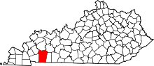 | |
| CDPs | ||
| Unincorporated communities | ||
| Footnotes | ‡This populated place also has portions in an adjacent county or counties | |
This article is issued from Wikipedia - version of the 10/11/2016. The text is available under the Creative Commons Attribution/Share Alike but additional terms may apply for the media files.