Fairlee, Maryland
| Fairlee | |
|---|---|
| Census-designated place | |
 Fairlee  Fairlee Location within the state of Maryland | |
| Coordinates: 39°13′21″N 76°10′19″W / 39.22250°N 76.17194°WCoordinates: 39°13′21″N 76°10′19″W / 39.22250°N 76.17194°W | |
| Country | United States |
| State | Maryland |
| County | Kent |
| Area[1] | |
| • Total | 3.913 sq mi (10.13 km2) |
| • Land | 3.796 sq mi (9.83 km2) |
| • Water | 0.117 sq mi (0.30 km2) |
| Elevation | 79 ft (24 m) |
| Population (2010)[2] | |
| • Total | 490 |
| • Density | 130/sq mi (48/km2) |
| Time zone | Eastern (EST) (UTC-5) |
| • Summer (DST) | EDT (UTC-4) |
| Area code(s) | 410 & 443 |
| GNIS feature ID | 588770[3] |
Fairlee, Maryland is an unincorporated community and census-designated place in Kent County, Maryland, United States.[3] Its population was 490 as of the 2010 census.[2]
The Battle of Caulk's Field during the War of 1812 occurred near Fairlee on August 31, 1814; it was a victory for the local militia, and the British commander was killed during the fighting.
The Fairlee Manor Camp House and St. Paul's Church are listed on the National Register of Historic Places.[4]
References
- ↑ "US Gazetteer files: 2010, 2000, and 1990". United States Census Bureau. 2011-02-12. Retrieved 2011-04-23.
- 1 2 "American FactFinder". United States Census Bureau. Retrieved 2011-05-14.
- 1 2 "Fairlee". Geographic Names Information System. United States Geological Survey.
- ↑ National Park Service (2010-07-09). "National Register Information System". National Register of Historic Places. National Park Service.
Municipalities and communities of Kent County, Maryland, United States | ||
|---|---|---|
| Towns | 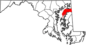 | |
| CDPs | ||
| Unincorporated communities | ||
| Footnotes | ‡This populated place also has portions in an adjacent county or counties | |
This article is issued from Wikipedia - version of the 10/29/2016. The text is available under the Creative Commons Attribution/Share Alike but additional terms may apply for the media files.