Engadine, New South Wales
| Engadine Sydney, New South Wales | |||||||||||||
|---|---|---|---|---|---|---|---|---|---|---|---|---|---|
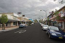 Shops on Old Princes Hwy | |||||||||||||
| Coordinates | 34°3′56.6″S 151°0′45.59″E / 34.065722°S 151.0126639°ECoordinates: 34°3′56.6″S 151°0′45.59″E / 34.065722°S 151.0126639°E | ||||||||||||
| Population | 16,867 (2011 census)[1] | ||||||||||||
| Postcode(s) | 2233 | ||||||||||||
| Time zone | AEST (UTC+10) | ||||||||||||
| • Summer (DST) | AEDT (UTC+11) | ||||||||||||
| Location | 33 km (21 mi) S of Sydney CBD | ||||||||||||
| LGA(s) | Sutherland Shire | ||||||||||||
| State electorate(s) | Heathcote | ||||||||||||
| Federal Division(s) | Hughes | ||||||||||||
| |||||||||||||
Engadine is a suburb in southern Sydney, in the state of New South Wales, Australia. Engadine is located 33 kilometres (21 mi) south of the Sydney central business district, in the local government area of the Sutherland Shire.
History
The area was reserved for a national park in 1879, but in 1890 Charles McAlister was able to purchase land here which became known as McAlister’s Estate. After an overseas trip, the family renamed their estate ‘Engadine’ after the Engadin Valley in Switzerland. The wildflowers in the valley here and surrounding national parks were reminiscent of the valley and hills in Engadin.
Charles McAlister subdivided his land sometime after 1900. He continued to live in Engadine but later moved to Cronulla, where he died in 1915.

Originally settled for grazing land, Engadine soon became a destination for camping and day-trips from the inner-Sydney suburbs. It remained isolated until 1920 when the railway station was built (with some funds donated by the local population). Many ex-soldiers settled here after World War I and several streets here recall this war and others as well, such as Anzac, Tobruk, Amiens, Bullecourt, Villers Brett, and Nelson.
Boys Town, in the western part of the suburb was modelled on an American Boys Town institution. The institution helps boys who have not been able to conform to the rules of society, regardless of their religious beliefs. It was founded in 1939 by Father T.V. Dunlea who was principal from 1939 to 1951.
The post office was opened on 1 January 1927 and the school opened in September 1932. In the 1960s, the district became more established as a residential area and Crown Land was released for private purchase. The remaining land-parcels were developed in the 1990s, in North Engadine and Woronora Heights.[2]
Landmarks
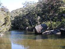
Engadine is bounded by The Royal National Park to the east, and Heathcote National Park to the west. Visitors to the suburb can view across the Sydney Basin from its southern edge across to the Sydney CBD. The area also features rolling sandstone slopes and cliffs in places, with an abundance of native trees throughout. Natural landmarks include 'the Needles' and 'the Blue Lagoon' along the Woronora River, and the Engadine Wetlands to the east of the railway station.
Commercial area
Engadine is mostly residential with some commercial and light industrial areas. The commercial area is located close to Engadine railway station and the Princes Highway. A shopping centre called Engadine Central includes supermarkets, grocery and specialty shops.
Transport
Engadine railway station is on the Illawarra line of the Sydney Trains network. It is located close to the Princes Highway. Bus Routes 991, 992, 993 and 996 are served by Transdev NSW.
Schools
- Engadine High School
- Engadine Public School
- Engadine West Public School
- Marton Public School
- St John Bosco College
- St John Bosco Primary School
Churches

- Connect Church
- Engadine Congregational Church
- Engadine Jehovah's Witnesses
- Engadine Uniting Church
- Exclusive Brethren
- Heathcote-Engadine Baptist Church
- Salvation Army
- Southern Cross Baptist Church
- St Andrews Presbyterian Church
- St Georges Anglican Church
- St John Bosco Catholic Church
- St John Bosco
Community
The Engadine community revolves around the town centre which comprises boutique shops, banks (the big four), restaurants, cafes, and four of the major supermarkets. At the heart of the township is the Engadine Community Centre which is a public meeting space and houses Essential Community Solutions (ECS).[3] ECS is a not for profit, non-government community-based organization. Established in the 1970s ECS works to enhance community capacity through the provision of programs and services for the aged, youth, children, families, individuals, people with a disability, their carers and the community as a whole.
Engadine District Youth Services (EDYS) provides free community assistance to the local youth, providing a safe, non-judgemental space where Young People can relax with friends, get involved in fun activities and also explore challenges or decisions they may be facing with the support of qualified Youth Workers. Most of the local churches also run community playtime groups for parents with pre-schoolers and also run community youth groups.
Annual free community events include the Rotary Club of Engadine's 'Carols for the People' (Cooper St Park) around Christmas each year since 2007; McAlister Community Fete run by the Lions Club with rides and stalls run at Cooper St Park annually since 1988; and 'Q Club' – a free daily kids program for primary aged kids in the community, running in the second week of the winter holidays at the Baptist Church every year since 1995.[4]
Parks and recreation

Public facilities include public parks, a skate park and gardens.
- Engadine Leisure Centre is a heated outdoor aquatic centre and gym
- Ferntree Reserve and Park, used by Engadine Eagles netball
- Anzac Oval is used for rugby league by the Engadine Dragons, Cricket by the Engadine Dragons CC, and Soccer by the Engadine Eagles
- Preston Park is used for soccer by the Engadine Crusaders F.C.[5] and cricket by the Engadine Dragons CC.
- Engadine Lawn Bowls Club
- Engadine Returned Services Club (RSL)
- Old Bush Road is used for rugby union by the Engadine Lions established in 1994, now featuring teams in the Illawarra and Sydney competitions.[6] Old Bush Rd is also used for touch footy in the Summer off-Season.
- Cooper Street Reserve
Services

- Engadine Rural Fire Brigade[7] protects the bush interface and valleys surrounding the Engadine area.
- Engadine Police Station
- Engadine Ambulance Station
Population
At the 2011 census, there were 16,867 residents in Engadine. The majority of people (84.6%) were born in Australia and the most common ancestries were Australian 34.7%, English 30.6% and Irish 9.6%. The top responses for religious affiliation were Catholic 31.9%, Anglican 28.6% and No Religion 17.2%. There were only 13.5% of people renting their home, with 37.9% owning their home outright and 46.8% paying a mortgage.[1]
Notable people
- Les Bursill – Aboriginal historian and archaeologist
- Markus Zusak – Author
- Robert Stone – (1956–2005), Australian Rugby League player for St. George Dragons
- Robbie Kearns – Australian Rugby League player
- Lindsay McDougall – Guitarist for Australian punk rock band Frenzal Rhomb
References
- 1 2 Australian Bureau of Statistics (31 October 2012). "Engadine (State Suburb)". 2011 Census QuickStats. Retrieved 2 May 2013.
- ↑ The Book of Sydney Suburbs, Compiled by Frances Pollon, Angus & Robertson Publishers, 1990, Published in Australia ISBN 0-207-14495-8, page 98
- ↑ "About". Essential Community Solutions. Retrieved 10 March 2015.
- ↑ http://hebc.org.au/go/qclub/
- ↑ Barden Ridge, New South Wales#Sport and recreation
- ↑ http://www.lions.rugby.com.au
- ↑ http://www.engadinerfs.org.au
External links
- Helen McDonald (2008). "Engadine". Dictionary of Sydney. Retrieved 27 September 2015. [CC-By-SA]