Edgar Township, Edgar County, Illinois
| Edgar Township | |
|---|---|
| Township | |
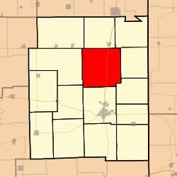 Location in Edgar County | |
 Edgar County's location in Illinois | |
| Coordinates: 39°44′20″N 87°42′05″W / 39.73889°N 87.70139°WCoordinates: 39°44′20″N 87°42′05″W / 39.73889°N 87.70139°W | |
| Country | United States |
| State | Illinois |
| County | Edgar |
| Established | November 4, 1856 |
| Area | |
| • Total | 55.31 sq mi (143.3 km2) |
| • Land | 55.31 sq mi (143.3 km2) |
| • Water | 0 sq mi (0 km2) 0% |
| Elevation | 650 ft (198 m) |
| Population (2010) | |
| • Total | 482 |
| • Density | 8.7/sq mi (3.4/km2) |
| Time zone | CST (UTC-6) |
| • Summer (DST) | CDT (UTC-5) |
| ZIP codes | 61917, 61924, 61940, 61944 |
| GNIS feature ID | 0428941 |
Edgar Township is one of fifteen townships in Edgar County, Illinois, USA. As of the 2010 census, its population was 482 and it contained 210 housing units.[1] Previously named Bloomfield Township, it received its current name on May 9, 1857.
Geography
The township is rural, with no incorporated towns or villages. Several unincorporated hamlets (Edgar, Horace, and Bloomfield) are located in the township. The townhouse is located at Edgar. According to the 2010 census, it has a total area of 55.31 square miles (143.3 km2), all land.[1]
Unincorporated towns
- Edgar
Extinct towns
- Bloomfield
- Horace
- Wetzel
Cemeteries
The township contains these six cemeteries: Bloomfield, Cherry Point, Franklin, Hoult, McKee and Scott.
Transportation
The township is served by several major state and federal highways. US Route 36 forms the northern boundary of the township, while Illinois Route 1 and US Route 150 cuts a north-south path through the township. The Edgar County Airport is located in the southeast part of the township. CSX operates a north-south length of railroad track that connects Chrisman and Paris.
Education
The township is served by three school districts: Shiloh Community Unit School District #1 , Chrisman-Scottland Community Unit School District #6 , and Crestwood Community Unit School District #4 .
Political districts
- Illinois' 15th congressional district
- State House District 109
- State Senate District 55
References
- "Edgar Township, Edgar County, Illinois". Geographic Names Information System. United States Geological Survey. Retrieved 2010-01-10.
- United States Census Bureau 2007 TIGER/Line Shapefiles
- United States National Atlas
- 1 2 "Population, Housing Units, Area, and Density: 2010 - County -- County Subdivision and Place -- 2010 Census Summary File 1". United States Census. Retrieved 2013-05-28.
External links
 |
Young America Township | Ross Township | Prairie Township | |
| Shiloh Township | |
Brouilletts Creek Township | ||
| ||||
| | ||||
| Buck Township | Paris Township | Hunter Township |
Municipalities and communities of Edgar County, Illinois, United States | ||
|---|---|---|
| Cities | ||
| Villages | ||
| Townships | ||
| Unincorporated communities | ||
| Footnotes | ‡This populated place also has portions in an adjacent county or counties | |