East Malaysia
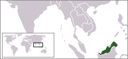
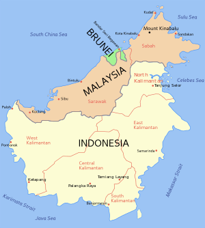
East Malaysia (Malaysia Timur), also known as Sabah, Sarawak and Labuan (Sabah, Sarawak dan Labuan)[1] or Malaysian Borneo,[2] is the part of Malaysia located on the island of Borneo. It consists of the Malaysian states of Sabah, Sarawak, and the Federal Territory of Labuan.[3] It lies to the east of Peninsular Malaysia (West Malaysia),[4] which is located on the Malay Peninsula. The two are separated by the South China Sea.[5] While East Malaysia is less populated and less developed than West Malaysia, its land mass is larger and it has notably more natural resources, chiefly oil and gas reserves.
History
Some parts of present-day East Malaysia, especially the coastal regions, were once part of the thalassocracy of the Sultanate of Brunei.[6] However, most parts of the interior region consisted of independent tribal societies.
In 1658, the northern and eastern coasts of Sabah were ceded to the Sultanate of Sulu while the west coast of Sabah and most of Sarawak remained part of Brunei. Beginning in the mid 19th century, Sabah and Sarawak became British protectorates, and, in 1946, they became separate British colonies.
Federation
Sabah (formerly British North Borneo) and Sarawak were separate British colonies from Malaya, and did not become part of the Federation of Malaya in 1957. However, each voted to become part of the new Federation of Malaysia along with the Federation of Malaya and Singapore in 1963. Previously, there were efforts to unite Brunei, Sabah, and Sarawak under the North Borneo Federation but that failed after the Brunei Revolt occurred.
Sabah and Sarawak retained a higher degree of local government and legislative autonomy than other states in West Malaysia. For example, both states have their own immigration controls, requiring Malaysian citizens from West Malaysia to carry passports or identity cards when visiting East Malaysia.
The islands of Labuan were once part of North Borneo (later Sabah) in 1946 before becoming a Federal Territory in Malaysia on 1984. It was used to establish a centre for offshore finance in 1990.
Since 2010, there has been some speculation and discussion, at least on the ground level, about the possibility of secession from the Federation of Malaysia[7] because of allegations of resource mishandling, illegal processing of immigrants, etc.[8]
Administration
It has been a source of debate whether the states of Sabah and Sarawak joined the Federation of Malaysia as equal partners with Malaya and Singapore or whether they became merely equal partners of the states of Malaya (Peninsular Malaysia).[9] The consensus seems to be that Sabah and Sarawak are merely states of the federation with a slightly higher degree of autonomy compared to states in Peninsular Malaysia. For example, the East Malaysian states have separate laws regulating the entry of citizens from other states in Malaysia (including the other East Malaysian state), whereas, in Peninsular Malaysia, there are no restrictions on interstate travel or migration, including visitors from East Malaysia. There are also separate land laws governing Sabah and Sarawak, as opposed to the National Land Code, which governs Peninsular Malaysia.
With regard to the administration of justice, the courts in East Malaysia are part of the federal court system in Malaysia. The Constitution of Malaysia provides that there shall be two High Courts of co-ordinate jurisdiction – The High Court in Malaya and the High Court in Sabah and Sarawak (formerly the High Court in Borneo). The current Chief Judge of Sabah and Sarawak is Richard Malanjum from Sabah. His office is the fourth highest in the Malaysian judicial system (behind the Chief Judge of Malaya, President of the Court of Appeal, and Chief Justice of Malaysia).
Politics
In 1976, all the Sabah and Sarawak MPs supported the Malaysian parliament bill which downgraded both the states from equal partners to one of the 13 states in the federation.[10] Sarawak, Sabah and Labuan currently holding a total of 57 out 222 seats (25.68%) in the Malaysian parliament with majority of the seats going to the ruling coalition Barisan Nasional ever since the two states hold their first state elections. However, Jeffrey Kitingan from Sabah, who is vocal of East Malaysian rights, is concerned that the number of seats from East Malaysia is under-represented in the Malaysian parliament as compared to the ideal representation of 35% stated in the Cobbold Commission report.[11] After the conclusion of 2013 Malaysian general election, East Malaysia contributed a total of 47 parliamentary seats (35.34%) out of the 133 seats won by the Barisan Nasional coalition following the Barisan dismal performance in Peninsular Malaysia. This has resulted an increase in ministers and deputy ministers allocation for East Malaysia in the Malaysian Cabinet from 11 out of 57 portfolios in 2008 election to 20 out of 61 after the 2013 election.[12][13] On the basis that East Malaysia should be treated as equal partner as compared to the Peninsular, local lawmakers has urged the federal government since the year 2011 to appoint at least one deputy prime minister from East Malaysia into the federal cabinet.[14][15] Political parties in Sarawak and Sabah evolved independently of each other. Party switching and party leadership tussle are common in both the states.
Physical geography
The landscape of East Malaysia is mostly lowland rain forests with areas of mountain rain forest towards the interior regions.
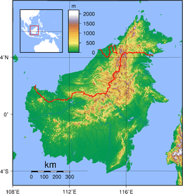
The total area of East Malaysia is 200,565 km2, representing approximately 61% of the total land area of Malaysia and 27% of the total area of Borneo.
East Malaysia contains the five highest mountains in Malaysia, the highest being Mount Kinabalu at 4095 m, which is also the highest mountain in Borneo and the 10th highest mountain peak in Southeast Asia. It also contains the two longest rivers in Malaysia – Rajang River and Kinabatangan River.[16]
Banggi Island in Sabah and Betruit Island in Sarawak are the two largest islands that are located entirely within Malaysia.[16] The largest island is Borneo, which is shared with Indonesia and Brunei.[17] The second largest island is Sebatik Island, in Sabah, which is shared with Indonesia.[18][19]
Sarawak contains the Mulu Caves within Gunung Mulu National Park. Its Sarawak Chamber is the largest known cave chamber in the world. The Gunung Mulu National Park was declared a UNESCO World Heritage Site in November 2000.[20]
Sabah's attractions include World Heritage Site Kinabalu Park (which includes Mount Kinabalu),[21] and Sipadan Island (a diving and bio-diversity hot-spot).[22]
Geology
Several oil and gas fields have been discovered offshore, including the Samarang oil field (1972) offshore Sabah, the Baronia oil field (1967) offshore Sarawak, and the Central Luconia natural gas fields (1968), also offshore Sarawak.[23] The Baronia Field is a domal structural trap between two east-west growth faults, which produces from late Miocene sandstones interbedded with siltstones and clays at 2 km depth in 75 m of water.[23]:431 The Samarang Field produces from late Miocene sandtones in an alternating sequence of sandstones, siltstones and clays in an anticline at a depth of about 3 km in water 9–45 m.[23]:431 The Central Luconia Gas Fields produce from middle to late Miocene carbonate platform and pinnacle reefs from 1.25-3.76 km deep and water depths 60-100m.[23]:436–437
Population
The total population of East Malaysia in 2010 was 5.77 million (3.21 million in Sabah, 2.47 million in Sarawak, and 0.09 million in Labuan),[24] which represents 20.4% of the population of Malaysia. A significant part of the population of East Malaysia today reside in towns and cities. The largest city and urban center is Kuching, which is also the capital of Sarawak and has a population of over 600,000 people. Kota Kinabalu is the second largest, and one of the most important cities in East Malaysia. Kuching, Kota Kinabalu, and Miri are the only three places with city status in East Malaysia. Other important towns include Sandakan and Tawau in Sabah, Sibu and Bintulu in Sarawak, and Victoria in Labuan.
The earliest inhabitants of East Malaysia are the Dayak people and other related ethnic groups such as the Dusun people. These indigenous people form a significant portion, but not the majority, of the population. For hundreds of years, there has been significant migration into East Malaysia and Borneo from many parts of the Malay Archipelago, including Java, the Lesser Sunda Islands, Sulawesi, and Sulu. More recently, there has been immigration from India and China.
The indigenous inhabitants were originally animists. Islamic influence began as early as the 15th century, while Christian influence started in the 19th century.
The indigenous inhabitants are generally partisan and maintain culturally distinct dialects of the Malay language, in addition to their own ethnic languages. Approximately 13% of the population of Sabah, and 26% of the population of Sarawak, is composed of ethnic Chinese Malaysians.
However, the demographics of Sabah has been altered dramatically with the alleged implementation of Project IC in the 1990s. Citizenships are alleged to be granted to immigrants of Indonesia and Philippines in order to keep the UMNO ruling party in power.[25] Royal Commission of Inquiry (RCI) has been conducted from 11 August 2012 to 20 September 2013. The outcome of the investigation was submitted to the prime minister on 19 May 2014.[26] The report was released on 3 December 2014 after 6 months delay. It is stated that Project IC may have existed which is responsible for the sudden spike in the state population. However, the report did not pinpoint anyone who is responsible except for "corrupt officials" who was taking advantage of the system.[27]
Education
East Malaysia currently has two public universities, namely Universiti Malaysia Sarawak (UNIMAS) and Universiti Malaysia Sabah (UMS). Universiti Teknologi Mara (UiTM) also has branch campuses in both states. Labuan's own institution of higher education is Universiti Malaysia Sabah Labuan International Campus, a branch of Universiti Malaysia Sabah in Sepanggar Bay, Kota Kinabalu. Labuan also has a matriculation college, Kolej Matrikulasi Labuan, the only matriculation college in East Malaysia. Thus, all pre-university students from Sabah, Sarawak, and Labuan must take their courses there.
UCSI University, Sarawak Campus, Tunku Abdul Rahman University College (Sabah campus), International University College Of Technology Twintech (Sabah campus), and Open University Malaysia (Sabah campus) have local private university branch campuses in East Malaysia.
Curtin University Sarawak and Swinburne University of Technology Sarawak Campus are foreign university branch campuses in Sarawak.
There are 4 teacher training colleges (Malay: Maktab Perguruan) in Sarawak, and 4 teacher training colleges in Sabah.[28]
Transport
The Pan Borneo Highway connects Sabah, Sarawak, and Brunei. The road has been poorly maintained since it was built. The narrow road is dark at night without any street lights and there are many danger spots, sharp bends, blind spots, potholes, and erosion.[29] However, federal government funds have been allocated for the upgrade of the highway, which will be carried out in stages until completion in 2025.[30]
The major airports in East Malaysia are Kuching International Airport, Labuan International Airport and Kota Kinabalu International Airport. There are frequent air flights by carriers including Malaysia Airlines (MAS) and AirAsia between East Malaysia and Peninsular Malaysia. Other ports of entry to East Malaysia include Sibu Airport, Bintulu Airport, and Miri Airport in Sarawak, Sandakan Airport and Tawau Airport in Sabah. MAS also operates international flights to major cities in East Malaysia.[31]
The rural areas in Borneo can only be accessed by air or river boat. River transport is especially prevalent in Sarawak because there are many large and long rivers, with Rajang River being the most used. Rivers are used by boats and ferries for communications (i.e. mail) and passenger transport between inland areas and coastal towns. Timber is also transported via vessels and log carriers down the rivers of Sarawak.[31]
The Labuan Ferry operates boat express and vehicle ferries from Labuan Island to Sabah, Sarawak and Brunei.[32] The ferries have overtaken the airport as the chief transportation mode for the island.
Security
The state of Sabah has been subjected to attacks by Moro pirates and militants since 1960s and attacks intensify in 1985, 2000, 2013 and until present. Eastern Sabah Security Zone (ESSZONE) and Eastern Sabah Security Command (ESSCOM) was established on 25 March 2013 to tighten security in the region. Since 2014, a 12-hour dusk-to-dawn curfew has been imposed on six Sabah east coast districts and it is still ongoing.[33]
References
- ↑ The term "Sabah , Sarawak dan Labuan" (Sabah , Sarawak dan Labuan) is more commonly used in Malaysia to avoid the connotation of "East Malaysia" and "West Malaysia" (Peninsular Malaysia) being two separate countries, as in former East Germany and West Germany.
- ↑ "Malaysia urged to scrap coal plant in eco-sensitive Borneo". AFP. 7 July 2010. Retrieved 8 July 2010.
- ↑ http://eur-lex.europa.eu/LexUriServ/LexUriServ.do?uri=OJ:L:2006:354:0019:0028:EN:PDF
- ↑ "Location". Malaysia Travel.org.uk. Retrieved 7 July 2010.
- ↑ "Malay Peninsula". HarperCollins Publishers. Retrieved 7 July 2010.
- ↑ Saunders, Graham E. (2002), A History of Brunei, RoutlegdeCurzon, p. 45, ISBN 9780700716982, retrieved 5 October 2009
- ↑ Push for Sabah, S'wak's independence: Next stop UN. Malaysia-today.net (2010-04-02). Retrieved on 2013-07-29.
- ↑ http://www.sarawakwatch.com/?p=13661[]
- ↑ "'Know Federal System' advice". Daily Express. 21 May 2010. Retrieved 9 July 2010.
- ↑ Chia, Jonathan (19 October 2016). "All round aye from Sabah, Sarawak". The Borneo Post. Archived from the original on 19 October 2016. Retrieved 20 October 2016.
- ↑ Rintod, Luke (8 March 2012). "'Sabah, Sarawak's 'right' to have more parliament seats'". Free Malaysia Today. Retrieved 16 June 2014.
- ↑ "20 ministers, deputy ministers from East Malaysia". Sin Chew Jit Poh. 16 May 2013. Retrieved 16 June 2014.
- ↑ "The new cabinet, by party and in numbers". Malaysiakini. 15 May 2013. Retrieved 16 June 2014.
- ↑ Chieh, Yow Hong (27 October 2011). "East Malaysian DPM gratuitous, says Dr M". The Malaysian Insider. Retrieved 16 June 2014.
- ↑ "Appoint DPMs from East M'sia, Putrajaya urged". Malaysiakini. 15 June 2014. Retrieved 16 June 2014.
- 1 2 Geography, Malaysiahistorical.com.my, retrieved 16 July 2010
- ↑ "Motorcycle tour description and itinerary for the Borneo-East Malaysia motorcycle tour.". Asian Bike Tour. Retrieved 20 July 2010.
- ↑ "Dive The Kakaban Island". De 'Gigant Tours. Retrieved 20 July 2010.
- ↑ "Sebatik Island off Sabah, Malaysia 1965". The Band of Her Majesty's Royal Marines. Retrieved 20 July 2010.
- ↑ "Gunung Mulu National Park". UNESCO.org. Retrieved 20 July 2010.
- ↑ "Kinabalu Park". UNESCO.org. Retrieved 20 July 2010.
- ↑ Noreen (10 January 2010). "Diving at Sipadan Island, Borneo – An Untouched Piece of Art". Aquaviews: Online Scuba Magazine. Retrieved 20 July 2010.
- 1 2 3 4 Scherer, F.C., 1980, Exploration in East Malaysia Over the Past Decade, in Giant Oil and Gas Fields of the Decade, AAPG Memoir 30, Halbouty, M.T., editor, Tulsa, American Association of Petroleum Geologists, ISBN 0891813063, p. 424
- ↑ "Chart 3: Population distribution by state, Malaysia, 2010" (PDF). Population Distribution and Basic Demographic Characteristics 2010 (in Malay and English). Department of Statistics, Malaysia. p. 2 (p. 13 in PDF). Retrieved 13 December 2012.
- ↑ "SPECIAL REPORT: Sabah's Project M (subscription required)". Malaysiakini. 27 June 2006. Retrieved 23 June 2014.
- ↑ "RCI report on Sabah's illegal immigrants handed to PM, Agong". The Malay Mail. 19 May 2014. Retrieved 23 June 2014.
- ↑ Chi, Melissa (3 December 2014). "'Corrupt officials' blamed for Sabah problems, but RCI says hands tied". The Malay Mail. Retrieved 10 December 2014.
- ↑ "Institut Pendidikan Guru (Teachers' Training Institute)". Kementerian Pendidikan Malaysia (Malaysian Ministry of Education). Archived from the original on 22 December 2015. Retrieved 22 December 2015.
IPG Kampus Sarawak, IPG Kampus Tun Abdul Razak, IPG Kampus Batu Lintang(1st page), ... IPG Kampus Rajang (2nd page)
- ↑ Then, Stephen (13 September 2013). "Repair Pan Borneo Highway now, says Bintulu MP following latest fatal accident". The Star (Malaysia). Retrieved 23 June 2014.
- ↑ "Pan Borneo Highway project will be carried out in stages, says minister". The Star (Malaysia). 14 November 2013. Retrieved 23 June 2014.
- 1 2 "Getting To Borneo By Air, By Car, By Train". Asia Web Direct. Retrieved 15 July 2010.
- ↑ "New Ferry launched for Labuan-Sabah-Brunei sea route". http://www.thestar.com.my. 2 May 2015. External link in
|journal=(help) - ↑ Chan, Julia (5 November 2014). "Sabah curfew renewed for the seventh time". The Malay Mail. Retrieved 6 November 2014.
External links
- Virtual Malaysia – The Official Portal of the Ministry of Tourism, Malaysia
Bibliography
- Andrew Harding & James Chin, 50 years of Malaysia: Federalism revisited (Marshall Cavendish 2014)
- Cabinet Memorandum. Policy in regard to Malaya and Borneo. Memorandum by the Secretary of State for the Colonies. 29 August 1945
- Manila Accord (31 July 1963)
- Exchange of notes constituting an agreement relating to the implementation of the Manila Accord of 31 July 1963
- Acts of the Parliament of the United Kingdom Malaysia Act 1963
- Agreement relating to Malaysia between United Kingdom of Great Britain and Northern Ireland, Federation of Malaya, North Borneo, Sarawak and Singapore
Coordinates: 3°N 114°E / 3°N 114°E
Malaysia articles | |||||||||||
|---|---|---|---|---|---|---|---|---|---|---|---|
| History |
|  | |||||||||
| Geography |
| ||||||||||
| Politics | |||||||||||
| Economy | |||||||||||
| Society |
| ||||||||||
| |||||||||||