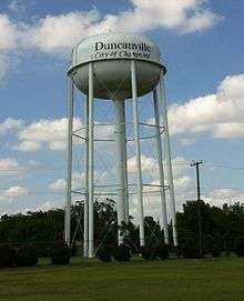
Duncanville, Texas
| Duncanville, Texas | |
|---|---|
| City | |
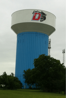
| Nickname(s): City of Champions | |
 Location of Duncanville in Dallas County, Texas | |
| Coordinates: 32°38′47″N 96°54′41″W / 32.64639°N 96.91139°WCoordinates: 32°38′47″N 96°54′41″W / 32.64639°N 96.91139°W | |
| Country |
|
| State |
|
| County | Dallas City Type: City |
| Government | |
| • Type | Council-Manager |
| • City Council |
Mayor David Green Dennis Schwartz Steven Rutherford Leslie Thomas Ron Dotson Johnette Jameson Patrick Harvey |
| • City Manager | Kevin Hugman |
| Area | |
| • City | 11.3 sq mi (29.2 km2) |
| • Land | 11.3 sq mi (29.2 km2) |
| • Water | 0.0 sq mi (0.0 km2) |
| Elevation | 725 ft (221 m) |
| Population (2010) | |
| • City | 38,524 |
| • Density | 3,400/sq mi (1,300/km2) |
| • Metro | 6,538,850 |
| Time zone | Central (UTC-6) |
| • Summer (DST) | Central (UTC-5) |
| ZIP codes | 75116, 75137, 75138 |
| Area code(s) | 972 |
| FIPS code | 48-21628[1] |
| GNIS feature ID | 1334786[2] |
| Website | www.duncanville.com |
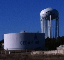
Duncanville is a city in southern Dallas County, Texas, in the United States. Duncanville's population was 38,524 at the 2010 census.[3] The city is part of the Best Southwest area, which includes Duncanville, Cedar Hill, DeSoto, and Lancaster.
Geography
Duncanville is located at 32°38′47″N 96°54′41″W / 32.64639°N 96.91139°W (32.646333, -96.911309).[4]
According to the United States Census Bureau, the city has a total area of 11.3 square miles (29 km2), all of it land.
History
Settlement of the area began in 1845, when Illinois resident Crawford Trees purchased several thousand acres south of Camp Dallas. In 1880 the Chicago, Texas and Mexican Central Railway reached the area and built Duncan Switch, named for a line foreman. Charles P. Nance, the community's first postmaster, renamed the settlement Duncanville in 1882. By the late 19th century Duncanville was home to a dry goods stores, a pharmacy, a domino parlor, and a school. Between 1904 and 1933 the population of Duncanville increased from 113 to more than 300.[5]
During World War II, the Army Air Corps established a landing field for flight training on property near the present-day intersection of Main and Wheatland roads.[6]
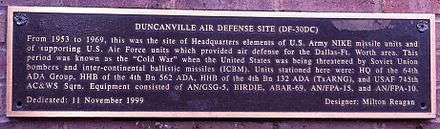
Duncanville residents incorporated the city on August 2, 1947. During the post-war years, the military developed the Army’s old landing field into the Duncanville Air Force Station, which was the headquarters for the four Nike-Hercules missile launch sites guarding Dallas/Fort Worth from Soviet bomber attack. It also housed the Air Force tracking radars for the region.[7]

When the town's population reached 5,000 in 1962, citizens adopted a home-rule charter with council-manager city government. Sometimes regarded as a "white flight" suburb in the 1960s and 1970s, the city is now known for its racial diversity (see "Demographics"). Its population increased from about 13,000 in 1970 to more than 31,000 in 1988.[5]
Historic preservation
The Texas Historical Commission has designated the City of Duncanville as an official Main Street City.[8]
Duncanville recognizes the importance of the former Duncanville Air Force Station. The Duncanville Air Force Station was closed on July 1, 1964; however the Army continued to operate the Nike Missile air defense operations until 1969 at which point, the facility was turned over to the city. The WWII-era barracks and some other structures were initially re-purposed for civic and community use. Over time the buildings were systematically demolished, obliterating all signs of the historic base. But the history of the facility lives on in a monument which stands outside the library and community center.
The "stone igloo", a spring house originally located near the intersection of Center Street and Cedar Ridge Road, was preserved in a unique way. In the late 1960s or early 1970s it was demolished, thereby producing a supply of rocks that were used to build a replica of the structure at a nearby park and paving the way for the construction of a neighborhood retail center.
Various pieces of the city's history are preserved at the Duncanville Historical Park, which is located on Wheatland Road in Armstrong Park on land that was once a part of the Duncanville Air Force Station. Historic buildings include the city’s first Music Room.[6]
Notable people
- Singer Elliott Smith moved to Duncanville after his parents divorced and stayed till age 14 when he went to live with his father in Portland, Oregon.[9]
- Ex-pro football player "Mean" Joe Greene lived in Duncanville during the height of his pro career with the Pittsburgh Steelers.
- Greg Ostertag is a 1991 graduate of Duncanville High School. He averaged 22.5 points and 13 rebounds per game during his senior season,[10] and capped the year by leading the Panthers to the 1991 state championship, the first-ever for the school's boys basketball team. After his successful high school career, Ostertag joined the basketball team at the University of Kansas from 1991-1995 and professionally for the Utah Jazz from 1995-2012.
- Tamika Catchings, WNBA all-star, graduated from Duncanville High School in 1997, having played on the women's basketball team that won the state championship. She is the first person to achieve a quintuple double.
- Tim Urban, an acoustic, contemporary musician who began his music career in 2007, and gained fame for making it into the top 7 on the ninth season of American Idol.
- Tim DeLaughter (born 18 November 1965 in Dallas, Texas), is a singer and songwriter. He has gained attention as a very energetic and engaging frontman for both Tripping Daisy and his current band, The Polyphonic Spree.
- Current Kansas City Chiefs running back, Cyrus Gray, played his freshmen year of high school football for Duncanville High School before he moved to DeSoto.
- Perry Jones, forward for the Oklahoma City Thunder, played basketball at Duncanville High School.
- The current Texas Governor, Greg Abbott, is a 1976 graduate of Duncanville High School.
- Linguist and author Kenneth Lee Pike lived in Duncanville for many years, later moving to a nearby neighborhood in Dallas. While he lived in Duncanville, US Senator Alan J. Dixon and US Congressman Paul Simon announced that they had nominated Pike for the Nobel Peace Prize[11] (though the Nobel Prize Committee does not officially announce nominations).
Government and infrastructure
Duncanville City Hall is located at 203 E. Wheatland Road Duncanville, TX 75116. Most city services are located in this facility which also includes the Duncanville Recreation Center featuring meeting rooms, a double gymnasium, and an indoor walking track. Armstrong Park is also located next to City Hall.Duncanville has 3 walking trails, 17 city parks, and many other recreation spaces for team sports.[12]
U.S. Route 67 runs through the eastern portion of Duncanville. Interstate 20 passes through the northern portion of Duncanville.
The United States Postal Service operates the Duncanville Post Office.[13]
The Duncanville Public Library is located at 201 James Collins Boulevard Duncanville, Texas.
The city of Duncanville is a voluntary member of the North Central Texas Council of Governments association, the purpose of which is to coordinate individual and collective local governments and facilitate regional solutions, eliminate unnecessary duplication, and enable joint decisions.
Demographics
| Historical population | |||
|---|---|---|---|
| Census | Pop. | %± | |
| 1950 | 841 | — | |
| 1960 | 3,774 | 348.8% | |
| 1970 | 14,105 | 273.7% | |
| 1980 | 27,781 | 97.0% | |
| 1990 | 35,748 | 28.7% | |
| 2000 | 36,081 | 0.9% | |
| 2010 | 38,524 | 6.8% | |
| Est. 2015 | 39,826 | [14] | 3.4% |
As of the 2010 census Duncanville had a population of 38,524. The racial and ethnic makeup of the population was 32.3% non-Hispanic white, 29.4% non-Hispanic black, 0.7% Native American, 1.7% Asian, 0.1% Pacific Islander, 0.1% non-Hispanic from some other race, 2.5% reporting two or more races and 35.0% Hispanic or Latino of any race.[16]
As of the census[1] of 2000, there were 36,083 people, 12,899 households, and 10,239 families residing in the city. The population density was 3,196.6 people per square mile (1,233.9/km²). There were 13,290 housing units at an average density of 1,177.4 per square mile (454.5/km²). The racial makeup of the city was 63.90% White, 24.76% African American, 0.32% Native American, 1.99% Asian, 0.09% Pacific Islander, 6.83% from other races, and 2.11% from two or more races. Hispanic or Latino of any race were 15.30% of the population.
There were 12,896 households out of which 38.4% had children under the age of 18 living with them, 59.3% were married couples living together, 16.1% had a female householder with no husband present, and 20.6% were non-families. 17.6% of all households were made up of individuals and 5.7% had someone living alone who was 65 years of age or older. The average household size was 2.79 and the average family size was 3.15.
In the city the population was spread out with 28.1% under the age of 18, 8.5% from 18 to 24, 27.7% from 25 to 44, 26.1% from 45 to 64, and 9.6% who were 65 years of age or older. The median age was 36 years. For every 100 females there were 90.0 males. For every 100 females age 18 and over, there were 85.0 males.
The median income for a household in the city was $51,654, and the median income for a family was $57,064. Males had a median income of $39,199 versus $30,145 for females. The per capita income for the city was $22,924. The Average Household Income for the city in 2008 is $82,500. About 3.9% of families and 6.1% of the population were below the poverty line, including 8.2% of those under age 18 and 3.6% of those age 65 or over.
Education
Duncanville is served by the Duncanville Independent School District.
The Duncanville ISD portion is zoned to Duncanville High School, which enrolls approximately 3,750 students annually. Duncanville High School currently enrolls over 4,000 students during the 2010–2011 school year.[17] At about 900,000 square feet (84,000 m2), the Duncanville High School campus is the largest in Texas, the largest in the nation, and the largest in the world in terms of physical size. In total, 13 out of the 17 schools in the district are rated Exemplary or Recognized by the TEA Texas Education Agency, and the district's ratings continue to outperform those of the surrounding districts (Cedar Hill, DeSoto, Lancaster, Dallas, Grand Prairie). They also outperform many of the school districts throughout the Dallas-Fort Worth area.
Duncanville is also home to the administrative offices of Advantage Academy.
 |
Dallas | Dallas | Dallas | |
| Dallas | |
Dallas | ||
| ||||
| | ||||
| Cedar Hill | Cedar Hill | Cedar Hill |
References
- 1 2 "American FactFinder". United States Census Bureau. Retrieved 2008-01-31.
- ↑ "US Board on Geographic Names". United States Geological Survey. 2007-10-25. Retrieved 2008-01-31.
- ↑ "Profile of General Population and Housing Characteristics: 2010 Demographic Profile Data (DP-1): Duncanville city, Texas". U.S. Census Bureau, American Factfinder. Retrieved January 12, 2012.
- ↑ "US Gazetteer files: 2010, 2000, and 1990". United States Census Bureau. 2011-02-12. Retrieved 2011-04-23.
- 1 2 "Handbook of Texas". Tshaonline.org. 2013-08-11. Retrieved 2013-08-29.
- 1 2 "Duncanville, Texas | Tourism - Presented by Village Profile". Villageprofile.com. Retrieved 2013-08-29.
- ↑ "Nike Missile Dallas-Fort Worth Defense Area". Techbastard.com. Retrieved 2013-08-29.
- ↑ State of Texas and UTA. "CRAC Industry Profiles". Crc.uta.edu. Retrieved 2013-08-29.
- ↑ "biography - page 2". sweet adeline. Retrieved 2013-08-29.
- ↑ Houston Chronicle: "Big Guy Concerns North Shore"
- ↑ p. xiv,xv. Jankowsky, Kurt R., ed. 1996. The Mystery of Culture Contacts, Historical Reconstruction, and Text Analysis: An Emic Approach. Washington, DC: Georgetown University Press.
- ↑ "." Duncanville City Website. Retrieved on October 25, 2013.
- ↑ "Post Office Location - DUNCANVILLE." United States Postal Service. Retrieved on September 8, 2010.
- ↑ "Annual Estimates of the Resident Population for Incorporated Places: April 1, 2010 to July 1, 2015". Retrieved July 2, 2016.
- ↑ "Census of Population and Housing". Census.gov. Retrieved June 4, 2015.
- ↑ 2010 report on population and housing characteristics for Duncanville from the US Census
- ↑ Greatschools.net - Duncanville High School. Retrieved 17 June 2006.
External links
- City of Duncanville official website
- Duncanville Chamber of Commerce
- Duncanville Independent School District
Municipalities and communities of Dallas County, Texas, United States | ||
|---|---|---|
| Cities | 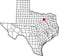 | |
| Towns | ||
| Unincorporated communities | ||
| Historical communities | ||
| Footnotes | ‡This populated place also has portions in an adjacent county or counties | |