Dolalghat
| Dolalghat दोलालघाट | |
|---|---|
| Village development committee | |
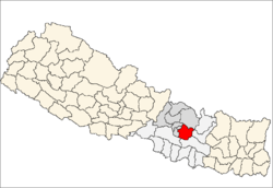
 Dolalghat Location in Nepal | |
| Coordinates: 27°38′05″N 85°42′08″E / 27.6346°N 85.7023°ECoordinates: 27°38′05″N 85°42′08″E / 27.6346°N 85.7023°E | |
| Country | Nepal |
| Zone | Bagmati Zone |
| District | Kabhrepalanchok District |
| Population (1991) | |
| • Total | 1,714 |
| Time zone | Nepal Time (UTC+5:45) |
Dolalghat is a village development committee in Kabhrepalanchok District in the Bagmati Zone of central Nepal.
Demographics
At the time of the 1991 Nepal census it had a population of 1714 and had 323 houses in it.[1]
Transport
It is on Araniko Highway.[2]
References
- ↑ "Nepal Census 2001". Nepal's Village Development Committees. Digital Himalaya. Retrieved 2008-09-01.
- ↑ Dorje, Gyurme. Footprint Tibet Handbook: with Bhutan. Arniko Highway to Tibet, p. 818. Google books. Retrieved 2010-05-14.
External links
This article is issued from Wikipedia - version of the 9/21/2016. The text is available under the Creative Commons Attribution/Share Alike but additional terms may apply for the media files.