Dienne
| Dienne | ||
|---|---|---|
|
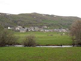
A general view of Dienne | ||
| ||
 Dienne | ||
|
Location within Auvergne-Rhône-Alpes region  Dienne | ||
| Coordinates: 45°09′34″N 2°47′16″E / 45.1594°N 2.7878°ECoordinates: 45°09′34″N 2°47′16″E / 45.1594°N 2.7878°E | ||
| Country | France | |
| Region | Auvergne-Rhône-Alpes | |
| Department | Cantal | |
| Arrondissement | Saint-Flour | |
| Canton | Murat | |
| Intercommunality | Pays de Murat | |
| Government | ||
| • Mayor (2008–2014) | Jean-Claude Cheyvialle | |
| Area1 | 46.33 km2 (17.89 sq mi) | |
| Population (2008)2 | 255 | |
| • Density | 5.5/km2 (14/sq mi) | |
| Time zone | CET (UTC+1) | |
| • Summer (DST) | CEST (UTC+2) | |
| INSEE/Postal code | 15061 / 15300 | |
| Elevation |
1,015–1,561 m (3,330–5,121 ft) (avg. 1,050 m or 3,440 ft) | |
|
1 French Land Register data, which excludes lakes, ponds, glaciers > 1 km² (0.386 sq mi or 247 acres) and river estuaries. 2 Population without double counting: residents of multiple communes (e.g., students and military personnel) only counted once. | ||
.svg.png)
Dienne is a commune in the Cantal department in south-central France.
Population
| Historical population | ||
|---|---|---|
| Year | Pop. | ±% |
| 1962 | 655 | — |
| 1968 | 583 | −11.0% |
| 1975 | 496 | −14.9% |
| 1982 | 396 | −20.2% |
| 1990 | 359 | −9.3% |
| 1999 | 293 | −18.4% |
| 2008 | 255 | −13.0% |
See also
References
| Wikimedia Commons has media related to Dienne. |
This article is issued from Wikipedia - version of the 2/15/2015. The text is available under the Creative Commons Attribution/Share Alike but additional terms may apply for the media files.