Tournemire, Cantal
| Tournemire | |
|---|---|
|
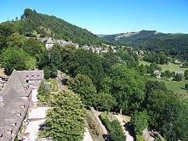
Tournemire seen from the Château d'Anjony | |
 Tournemire | |
|
Location within Auvergne-Rhône-Alpes region  Tournemire | |
| Coordinates: 45°03′19″N 2°28′59″E / 45.0553°N 2.4831°ECoordinates: 45°03′19″N 2°28′59″E / 45.0553°N 2.4831°E | |
| Country | France |
| Region | Auvergne-Rhône-Alpes |
| Department | Cantal |
| Arrondissement | Aurillac |
| Canton | Saint-Cernin |
| Intercommunality | Pays de Salers |
| Government | |
| • Mayor (2008–2014) | Jean-Pierre Fruquieres |
| Area1 | 9.68 km2 (3.74 sq mi) |
| Population (2008)2 | 141 |
| • Density | 15/km2 (38/sq mi) |
| Time zone | CET (UTC+1) |
| • Summer (DST) | CEST (UTC+2) |
| INSEE/Postal code | 15238 / 15310 |
| Elevation |
708–1,046 m (2,323–3,432 ft) (avg. 780 m or 2,560 ft) |
|
1 French Land Register data, which excludes lakes, ponds, glaciers > 1 km² (0.386 sq mi or 247 acres) and river estuaries. 2 Population without double counting: residents of multiple communes (e.g., students and military personnel) only counted once. | |
Tournemire (Occitan: Tornamira) is a commune in the Cantal department in south-central France.
Population
| Historical population | ||
|---|---|---|
| Year | Pop. | ±% |
| 1962 | 272 | — |
| 1968 | 299 | +9.9% |
| 1975 | 214 | −28.4% |
| 1982 | 183 | −14.5% |
| 1990 | 163 | −10.9% |
| 1999 | 145 | −11.0% |
| 2008 | 141 | −2.8% |
See also
References
| Wikimedia Commons has media related to Tournemire (Cantal). |
This article is issued from Wikipedia - version of the 2/16/2015. The text is available under the Creative Commons Attribution/Share Alike but additional terms may apply for the media files.