Delorme, West Virginia
| Delorme, West Virginia | |
|---|---|
| Unincorporated community | |
 Delorme, West Virginia  Delorme, West Virginia | |
| Coordinates: 37°34′09″N 82°08′31″W / 37.56917°N 82.14194°WCoordinates: 37°34′09″N 82°08′31″W / 37.56917°N 82.14194°W | |
| Country | United States |
| State | West Virginia |
| County | Mingo |
| Elevation | 725 ft (221 m) |
| Time zone | Eastern (EST) (UTC-5) |
| • Summer (DST) | EDT (UTC-4) |
| Area code(s) | 304 & 681 |
| GNIS feature ID | 1538118[1] |
Delorme, also known as Edgarton, is an unincorporated community in Mingo County, West Virginia, United States. Delorme is located along the Tug Fork across from the state of Kentucky.
It was formerly served by the Norfolk and Western Railway[2] and reportedly once had as many as seven bars.[2]
References
- ↑ "US Board on Geographic Names". United States Geological Survey. 2007-10-25. Retrieved 2008-01-31.
- 1 2 Goodell, Jeff (November 29, 2010). "The Dark Lord of Coal Country". Rolling Stone. Retrieved June 2, 2011.
Municipalities and communities of Mingo County, West Virginia, United States | ||
|---|---|---|
| City | 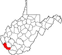 | |
| Towns | ||
| CDPs | ||
| Other communities |
| |
| Footnotes | ‡This populated place also has portions in an adjacent county or counties | |
This article is issued from Wikipedia - version of the 7/28/2016. The text is available under the Creative Commons Attribution/Share Alike but additional terms may apply for the media files.