Deel, Virginia
| Deel, Virginia | |
|---|---|
| Unincorporated community | |
 Deel, Virginia  Deel, Virginia | |
| Coordinates: 37°14′10″N 82°05′17″W / 37.23611°N 82.08806°WCoordinates: 37°14′10″N 82°05′17″W / 37.23611°N 82.08806°W | |
| Country | United States |
| State | Virginia |
| County | Buchanan |
| Elevation | 1,394 ft (425 m) |
| Time zone | Eastern (EST) (UTC-5) |
| • Summer (DST) | EDT (UTC-4) |
| Area code(s) | 276 |
| GNIS feature ID | 1499332[1] |
Deel is an unincorporated community in Buchanan County, Virginia, United States. Deel is located on U.S. Route 360 3 miles (4.8 km) south-southeast of Grundy.
History
A post office was established at Deel in 1908, and remained in operation until it was discontinued in 1957.[2] Raul Deel served as postmaster.[3]
References
- ↑ U.S. Geological Survey Geographic Names Information System: Deel, Virginia
- ↑ "Buchanan County". Jim Forte Postal History. Retrieved 28 September 2014.
- ↑ Tennis, Joe (2004). Southwest Virginia Crossroads: An Almanac of Place Names and Places to See. The Overmountain Press. p. 4. ISBN 978-1-57072-256-1.
Municipalities and communities of Buchanan County, Virginia, United States | ||
|---|---|---|
| Town | 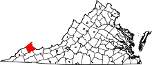 | |
| CDP | ||
| Unincorporated communities |
| |
| Footnotes | ‡This populated place also has portions in an adjacent county or counties | |
This article is issued from Wikipedia - version of the 11/2/2016. The text is available under the Creative Commons Attribution/Share Alike but additional terms may apply for the media files.