Daun, Germany
| Daun | ||
|---|---|---|
 | ||
| ||
 Daun | ||
Location of Daun within Vulkaneifel district  | ||
| Coordinates: 50°11′55″N 6°49′55″E / 50.19861°N 6.83194°ECoordinates: 50°11′55″N 6°49′55″E / 50.19861°N 6.83194°E | ||
| Country | Germany | |
| State | Rhineland-Palatinate | |
| District | Vulkaneifel | |
| Municipal assoc. | Daun | |
| Government | ||
| • Mayor | Wolfgang Jenssen (SPD) | |
| Area | ||
| • Total | 48.97 km2 (18.91 sq mi) | |
| Population (2015-12-31)[1] | ||
| • Total | 7,994 | |
| • Density | 160/km2 (420/sq mi) | |
| Time zone | CET/CEST (UTC+1/+2) | |
| Postal codes | 54550 | |
| Dialling codes | 06592 | |
| Vehicle registration | DAU | |
| Website |
www | |


Daun is a town in the Vulkaneifel district in Rhineland-Palatinate, Germany. It is the district seat and also the seat of the Verbandsgemeinde of Daun.
Geography
Location
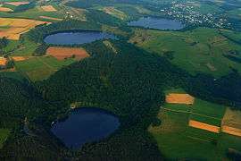
The town lies in the Vulkaneifel, a part of the Eifel known for its volcanic history, geographical and geological features, and even ongoing activity today, including gases that sometimes well up from the earth. Daun lies south of the High Eifel on the river Lieser. Found from 2.5 to 3.5 km southeast of Daun’s town centre are the Dauner Maare, a group of three volcanic lakes separated almost wholly by only the walls of tuff between them. The town is home to the Eifel-Vulkanmuseum. Daun is furthermore a spa town and has mineral water springs.
Constituent communities
The district seat of Daun has 8,514 inhabitants (as of 31 December 2005, counting only those with their main residence in the town). Besides the main town, also called Daun (4,264 inhabitants), the municipal area also includes these outlying centres (Stadtteile) that were formerly self-administering municipalities:
| Centre | Population | amalgamated |
|---|---|---|
| Boverath | 564 | 7 June 1969 |
| Gemünden | 215 | 1 April 1938 |
| Neunkirchen | 547 | 7 June 1969 |
| Pützborn | 1,129 | 7 June 1969 |
| Rengen | 438 | 7 November 1970 |
| Steinborn | 410 | 7 November 1970 |
| Waldkönigen | 699 | 7 November 1970 |
| Weiersbach | 251 | 10 June 1979 |
History
The first settlement in the area came as early as the 7th century BC by which time the Celts had settled the fortified basalt mountain in Daun. The Romans, too, used this prominent hill in the Lieser valley as a watch post, as witnessed by Roman finds. The placename may have come from the Celtic-Roman word Dunum, meaning either “fence” or “fortified heights”, that is to say, a fort.
In the late 10th century, a castle complex belonging to the free Lords of Daun arose here. In 1075, Daun had its first documentary mention in a townsman named Adalbero de Duna.
In 1163, the free lords’ family died out. One of the family’s ministeriales, Richardus de Duna, took over his former Lord’s name and even the coat of arms with the Daun fretting. In 1337, Daun is mentioned for the first time as being a town. In 1346 came a grant of town rights along with market rights, and Daun became at the same time the location of a high court.
In 1712, the Electoral-Trier Amtshaus was built by the Elector of Trier and Archbishop Karl-Josef on the Burgberg ("Castle Mountain"). After a transitory occupation by the French beginning in 1794, the village passed in 1815 to the Kingdom of Prussia. In 1817, Daun became seat of the district and an Amt mayoralty, and also at the same time a district administrator’s seat. Since 1947, it has been part of the then newly founded state of Rhineland-Palatinate. Beginning in 1951, Daun could once more call itself a town.

On 15 May 1895, Daun was linked to the German railway network with the Eifelquerbahn ("Cross-Eifel Railway"). On 1 December 1909, a further railway line, the Maare-Mosel-Bahn to Wittlich came into service. All public rail transport, however, ended in Daun more than a decade ago, although a two-hourly daytime service for tourists has been running in the summertime since 2005 on part of the Eifelquerbahn. The Maare-Mosel-Bahn, on the other hand, was torn up about a decade ago and has since become the Maare-Mosel-Radweg, a cycle path.
In 1965, Daun became a garrison town, housing at the Heinrich Hertz Barracks, among others, two signal corps units and one signals intelligence unit.
Politics
Town council
The council is made up of 12 council members, who were elected at the municipal election held on 7 June 2009, and the mayor as chairman.
Mayor
Daun’s mayor is Wolfgang Jenssen, and his three deputies are Otmar Monschauer, Hans-Dieter Wilhelm and Manfred Krag.[2]
Coat of arms
The town’s arms might be described thus: Or fretty gules.
The arms now borne by the town are the ones once borne by the Lords of Daun, and date from the 13th century. When the Lords died out, the town passed to the Electorate of Trier, thus explaining the Cross of Trier that appeared in seals dating from the 16th and following centuries. The current arms, however, are the Lords’ original ones.
The Armorial Wijnbergen, dating from c. 1270 - c. 1285, includes Ferry II of Daun, lord of Oberstein (blazon: Argent fretty sable).[3]
Town partnerships
Daun fosters partnerships with the following places:
Culture and sightseeing
.jpg)
Natural monuments
- Gemünd Maar
- Schalkenmehren Maar
- Weinfeld Maar
A maar is a broad-low relief volcanic crater often filled with rainwater. Tuff rings sometimes surround a maar. There are many in the Volcanic Eifel.
Buildings
- Daun Castle (Dauner Burg)
- Electoral-Trier Amtshaus (today a hotel) from 1712
- Evangelical church (1865/67)
- Tithe barn from 1740
- Burgmann houses: Waldenhof, Hof Rademacher
- Railway viaduct from 1909
- Saint Nicholas’s Catholic Parish Church, west tower and crypt Romanesque, mid 13th century, new building work done between 1946 and 1969
- Railway station building, roof with half-hipped gables, 1895
- Former Evangelical graveyard with elaborate grave markers from the 19th century
- Former mayoral building (Burgfriedstraße 25)
- Kampbüchelskreuz (cross) from about 1825 (Leopoldstraße, at the marketplace)
- Former Kaiserbrunnen (“Emperor’s Fountain”), 1911, warriors’ memorial from after 1945 (Leopoldstraße, at the former district administrator’s office)
- Former district administrator’s office, 1830/31, today the Volcano Museum (Leopoldstraße)
- Former recreation home of the department store chain Leonhard Tietz (Kaufhof), 1910
- Former Amt court from 1860 (Wirichstraße, today a savings bank branch)
- Warriors’ memorial 1870/71
- Former school building from about 1910/20 (Leopoldstraße 34, today a civil registry office)


.jpg)

Museums
- Volcano Museum, Daun (Vulkanmuseum Daun) – about volcanic and other geological phenomena.
Regular events
- Every other year, the Krimi-Festival Tatort Eifel ("Crime Novel Festival, Crime Scene Eifel") is held in Daun, to which come notable crime fiction authors from all over German-speaking Europe. Within the framework of this festival, the Deutsche Kurzkrimi-Preis (“German Short Crime Story Prize”) is awarded.
- The St.-Laurentius-Kirmes begins each year on the Saturday after the first Wednesday in August and lasts five days. It is among the Eifel’s biggest folk festivals.
- VulkanBike Eifel-Marathon (a mountainbike marathon through the Eifel mountains, also: VulkanBike trailpark, VulkanBike extreme and VulkanBike crosscountry)
- ADAC Eifel Rallye
- Maare-Mosel-Lauf (walk)
- Flugplatzfest Ende August (“Late-August Airfield Festival”)
- Spring Festival
Economy and infrastructure
Established businesses
- TechniSat Digital GmbH
- apra-norm Elektromechanik GmbH
Bundeswehr
Near Daun are the Heinrich Hertz Barracks, which house, among other units:
- Fernmeldebereich 93 (SKB; Signal Corps Division 93)
- Fernmeldeaufklärungsabschnitt 931 (SKB; Signal Intelligence section 931)
- Parts of the Bundeswehr Mayen service centre (WV)
- Daun Medical Centre (ZSan)
Media
In Daun there are an “open channel” and local editions of the Trierischer Volksfreund, the Eifelzeitung and the Wochenspiegel. Daun also has a multiplex cinema, the Kinopalast Vulkaneifel.
Education
General:
- Primary school
- Hauptschule
- Leopold-von-Daun Realschule
- Geschwister-Scholl-Gymnasium
- Thomas-Morus-Gymnasium
Vocational:
- Krankenpflegeschule Maria-Hilf (nursing)
- Fachschule für Altenpflege Maria-Hilf (geriatric care)
- St. Laurentius-Förderzentrum
Other schools:
- Music school
- Bildungszentrum der Bundesagentur für Arbeit (Training centre of the Federal Agency for Labour)
Clubs
Sport:
- TuS 05 Daun
- SV Neunkirchen-Steinborn
- SC Rot-Weiß Rengen
- KSC Daun-Weiersbach
Transport
Daun is linked to the Autobahn A 1. Also, Bundesstraßen 421 and 257 lead through the town. The town is linked to the railway network through the railway station on the Eifelquerbahn, running from Gerolstein to Andernach.
Famous people
Sons and daughters of the town
- Johannes Caspers (1910–1986), politician
- Oscar W. Gabriel (1947– ), sociologist and political scientist
- Karl Fleschen (1955– ), runner and Olympian
- Sebastian Dette (1958– ), former Federal judge and president of the General Accounting Office in Thuringia
- Karin Kortmann (1959– ), politician
- Thomas Leif (1959– ), journalist and political scientist
- Franziskus Wendels (1960– ), artist
- Pascal „Pommes“ Hens (1980– ), national handball player, handball world champion 2007
- Andreas Schäfer (1983– ), footballer
Famous people associated with the town
- Ägidius von Daun, Burgmann (14th century)
- Fritz von Wille (1860–1941), professor and landscape painter, in 1911 decorated the district centre in Daun with large-format murals.
- Pitt Kreuzberg (1888–1966), painter, close to Expressionism, painted in 1937 on a commission from the Nazi Party for the Hitler Youth clubhouse in Daun. The work displeased Party superiors and was rejected as “degenerate art”. The district administrator, however, stepped in and hung the picture in his office.
- Edmund Geisen (1949– ), politician, Member of the German Bundestag, lives in Daun.
Further reading
- Martina Knichel: "Gilles von Daun (1318-1358), Ritter und Räuber. Aus der Geschichte des Wanderns." - In: Jahrbuch für westdeutsche Landesgeschichte, 35 (2009), S. 73-86. ISSN 0170-2025
- Ingrid Schumacher, Gilles. Egidius von Daun und seine Zeit, Daun 2002
- Generaldirektion Kulturelles Erbe Rheinland-Pfalz (Hrsg.): "Nachrichtliches Verzeichnis der Kulturdenkmäler Kreis Vulkaneifel" (PDF). (1.0 MB). Koblenz 2010.
References
- ↑ "Gemeinden in Deutschland mit Bevölkerung am 31. Dezember 2015" (PDF). Statistisches Bundesamt (in German). 2016.
- ↑ Membership of Daun town council and various other municipal bodies.
- ↑ Timms, Brian. "The Armorial Wijnbergen". Rolls of Arms. Retrieved 2014-04-14.
- ↑ Partnerschaft zwischen der Gemeinde Carisolo (Trentino/Italien) und der Stadt Daun.
External links
| Wikimedia Commons has media related to Daun. |
- Official website (German)