Dala Township
| Dalla Township ဒလ မြို့နယ် | |
|---|---|
| Township of Yangon | |
| Dalla Township | |
 Dalla Township | |
| Coordinates: 16°45′30″N 96°9′30″E / 16.75833°N 96.15833°ECoordinates: 16°45′30″N 96°9′30″E / 16.75833°N 96.15833°E | |
| Country | Myanmar |
| Division | Yangon |
| City | Yangon |
| Township | Dalla |
| Area | |
| • Total | 28.3 km2 (10.93 sq mi) |
| Population (2000)[1] | |
| • Total | 74,000 |
| • Density | 2,600/km2 (6,800/sq mi) |
| Time zone | MST (UTC6:30) |
| Postal codes | 11261 |
| Area code(s) | 1 (mobile: 80, 99) |
| YCDC[1] | |
Dalla Township (Burmese: ဒလ မြို့နယ်, pronounced: [dəla̰ mjo̰nɛ̀]) is located on the southern bank of Yangon river across from downtown Yangon, Myanmar. The township, made up of 29 wards, is bounded by the Yangon river in the north and east, the Twante Canal in the west, and Twante Township in the south. Despite its strategic location near Yangon, the township is still largely rural and undeveloped mainly because it still lacks a bridge across the Yangon river.
Dalla has 30 primary schools and two high schools.[1]
It was, as Dalla, the site of the major shipyard of the Irrawaddy Flotilla Company.[2]

In Dalla
References
- 1 2 3 "Dalla Township". Yangon City Development Committee. Archived from the original on 2 October 2012. Retrieved 21 March 2009.
- ↑ Chubb, Capt H J; Duckworth, C L D (1973). The Irrawaddy Flotilla Company 1865-1950. Greenwich, London: National Maritime Museum.
Capital: Yangon | ||
| East Yangon District | 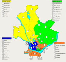 | |
| North Yangon District | ||
| South Yangon District | ||
| West Yangon District (Downtown) | ||
Capital: Yangon | ||
| East Yangon District |   | |
| North Yangon District | ||
| South Yangon District | ||
| West Yangon District (Downtown) | ||
| Main cities and towns | ||
| States | ||
|---|---|---|
| Regions | ||
| Self-Administered Zones | ||
| Self-Administered Divisions | ||
| Union Territories | ||
This article is issued from Wikipedia - version of the 3/26/2016. The text is available under the Creative Commons Attribution/Share Alike but additional terms may apply for the media files.