Kyimyindaing Township
| Kyimyindaing Township ကြည့်မြင်တိုင် မြို့နယ် | |
|---|---|
| Township of Yangon | |
| Kyimyindaing Township | |
 Kyimyindaing Township | |
| Coordinates: 16°48′11″N 96°7′27″E / 16.80306°N 96.12417°ECoordinates: 16°48′11″N 96°7′27″E / 16.80306°N 96.12417°E | |
| Country | Myanmar |
| Division | Yangon |
| City | Yangon |
| Township | Kyimyindaing |
| Area | |
| • Total | 5.6 km2 (2.16 sq mi) |
| Population (2000) | |
| • Total | 73,200 |
| • Density | 13,000/km2 (34,000/sq mi) |
| Time zone | MST (UTC6:30) |
| Postal codes | 11101 |
| Area code(s) | 1 (mobile: 80, 99) |
| YCDC[1] | |
Kyimyindaing Township (Burmese: ကြည့်မြင်တိုင် မြို့နယ်, pronounced: [tɕḭmjənàiɴ mjo̰nɛ̀]; also Kyeemyindaing Township or Kyi Myin Dine) is located in the western part of Yangon, and shares borders with Kamayut Township in the north, the Yangon River and Twante Township in the west, Sanchaung Township in the east, and Ahlon Township in the south. It consists of 21 wards. The township has 15 primary schools, three middle schools and five high schools.[1]
Landmarks
The following is a list of landmarks protected by the city in Kyimyindaing township.[2]
| Structure | Type | Address | Notes |
|---|---|---|---|
| Ohnbindan Sunni Jamahh Mosque | Mosque | 1-11 Ohnbin Lane | |
| St. Michael's Church | Church | 153 Upper Kyimyindaing Road | |
| Salin Monastery Ordination Hall | Monastery | Panbingyi Lane |
References
- 1 2 "Kyimyindaing Township". Yangon City Development Committee. Archived from the original on 2 October 2011. Retrieved 2009-03-14.
- ↑ "Special Reports: Heritage List". The Myanmar Times. 2001-10-29. Archived from the original on 15 June 2009.
Capital: Yangon | ||
| East Yangon District | 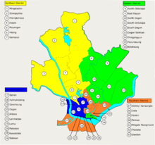 | |
| North Yangon District | ||
| South Yangon District | ||
| West Yangon District (Downtown) | ||
Capital: Yangon | ||
| East Yangon District |   | |
| North Yangon District | ||
| South Yangon District | ||
| West Yangon District (Downtown) | ||
| Main cities and towns | ||
| States | ||
|---|---|---|
| Regions | ||
| Self-Administered Zones | ||
| Self-Administered Divisions | ||
| Union Territories | ||
This article is issued from Wikipedia - version of the 4/29/2016. The text is available under the Creative Commons Attribution/Share Alike but additional terms may apply for the media files.