Compton, Berkshire
| Compton | |
 Medieval church of the ecclesiastical parish of Compton, dedicated to St Mary and St Nicholas |
|
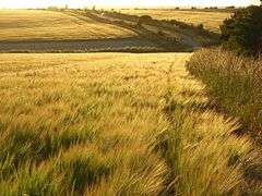 Fields of barley with narrow roadside hedgerows cover a large portion of Compton. |
|
 Compton |
|
| Area | 15.02 km2 (5.80 sq mi) |
|---|---|
| Population | 1,571 (2011 census)[1] |
| – density | 105/km2 (270/sq mi) |
| OS grid reference | SU5279 |
| Civil parish | Compton |
| Unitary authority | West Berkshire District Council |
| Ceremonial county | Berkshire |
| Region | South East |
| Country | England |
| Sovereign state | United Kingdom |
| Post town | Newbury |
| Postcode district | RG20 |
| Dialling code | 01635 |
| Police | Thames Valley |
| Fire | Royal Berkshire |
| Ambulance | South Central |
| EU Parliament | South East England |
| UK Parliament | Newbury |
| Website | Compton Parish Council |
Coordinates: 51°30′54″N 1°15′11″W / 51.515°N 1.253°W
Compton is a village and civil parish in the River Pang valley in the Berkshire Downs about 6 miles (9.7 km) south of Didcot which is buffered from neighbouring settlements by cultivated fields to all sides. The village is in a gently-sloped dry valley and the fledgling Pang seasonally enters from the north west and discharges in the south east and may be joined at the centre of the village by the Roden from the North, when winter bournes rise to fill their channels. Elevations vary from 95 to 155m AOD.
Parish church
The bell tower of the Church of England parish church of Saint Mary and Saint Nicholas was built in the 13th century[2] and has Perpendicular Gothic features[2] that were added in the 15th century.[3] In 1850 the nave and chancel were modernised[3] or rebuilt[2] and in 1905 the Gothic Revival architect John Oldrid Scott added the north aisle.[2]
Transport
Former railway
In 1882 the Didcot, Newbury and Southampton Railway was completed through the parish and Compton railway station was opened. British Railways withdrew passenger services from the line and closed Compton station in 1962. BR had closed Compton goods yard by 1964. Through freight traffic was withdrawn in 1964 and the line was closed and dismantled during 1967.
Bus service
From 18 February 2013, Compton is served by Newbury and District bus services 6 and 6A from Newbury.[4]
Amenities and economy
The academically successful The Downs School local authority secondary school is in Compton. In the 21st century its Science building was built, named The Hubble after American astro-physicist Edwin Hubble. The Primary School, Compton Church of England Primary School is located on School Road. The School emblem is a stag.
The Institute for Animal Health is at Compton. Substantial portions of the BBC Television series Trainer were filmed in and around Compton and the next nearest village, East Ilsley.
Demography
| Output area | Homes owned outright | Owned with a loan | Socially rented | Privately rented | Other | km² roads | km² water | km² domestic gardens | Usual residents | km² |
|---|---|---|---|---|---|---|---|---|---|---|
| Civil parish | 147 | 239 | 134 | 68 | 10 | 0.122 | 0.011 | 0.300 | 1571 | 15.02 |
Nearest places
 |
East Ilsley (part) | Blewbury | Aldworth (part) | |
| East Ilsley | |
Aldworth | ||
| ||||
| | ||||
| East Ilsley (part) | Hampstead Norreys | Aldworth (part) |
References
Sources
- Page, William; Ditchfield, P.H., eds. (1924). Victoria County History: A History of the County of Berkshire, Volume 4. pp. 15–21.
- Pevsner, Nikolaus (1966). The Buildings of England: Berkshire. Harmondsworth: Penguin Books. pp. 120–121.
External links
| Wikimedia Commons has media related to Compton, Berkshire. |
