Comondú Municipality
| Comondú | ||
|---|---|---|
| Municipality | ||
| ||
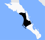 Location of Comondú in Baja California Sur. | ||
| Country | Mexico | |
| State | Baja California Sur | |
| Municipal seat | Ciudad Constitución | |
| Largest city | Ciudad Constitución | |
| Area | ||
| • Total | 18,354.82 km2 (7,086.84 sq mi) | |
| Population (March 21, 2015) | ||
| • Total | 73,857 (estimate) | |
| Time zone | MST (UTC−7) | |
| • Summer (DST) | MDT (UTC−6) | |
| INEGI code | 001 | |

Comondú is a municipality of the Mexican state of Baja California Sur. It had a population of 70,816 inhabitants in 2010 census (INEGI). With a land area of 16,858.3 km² (6,509.03 sq mi), it is the seventh-largest municipality in area in Mexico. The municipal seat is located in Ciudad Constitución.
The Spanish missions of San José de Comondú and San Luis Gonzaga are located in this municipality. Rocas Alijos, a group of tiny rocks that are 300 km west off the coast, are part of the municipality.
Politics
The Municipality of Comondú was one of the first three municipalities created in the then Federal South Territory of Baja California as part of a presidential decree of 1971, after a constitutional amendment allowing the creation and election of local councils in the territory, hitherto divided into political delegations. Dated January 1, 1972 Comondú was formally the first City Council. The township government rests with the council; it consists of the Mayor, a trustee and a council composed of fourteen aldermen; the city council is elected for a period of three years by popular vote (direct and secret), starting every April 30 of the election year.
Demographics
| Historical population | ||
|---|---|---|
| Year | Pop. | ±% |
| 1970 | 32,260 | — |
| 1980 | 57,729 | +78.9% |
| 1990 | 74,346 | +28.8% |
| 1992 | — | |
| 1995 | 66,096 | — |
| 2000 | 63,864 | −3.4% |
| 2005 | 63,830 | −0.1% |
| 2010 | 70,816 | +10.9% |
| 2015 | 73,857 | +4.3% |
| Included territory of Loreto Municipality until 1992. [1] | ||
As of 2010, the municipality had a total population of 70,816.[2]
The municipality had 1,516 localities, the largest of which (with 2010 populations in parentheses) were: Ciudad Constitución (40,935), Ciudad Insurgentes (8,741), Puerto San Carlos (5,538), classified as urban, and Puerto Adolfo López Mateos (2,212), Villa Ignacio Zaragoza (1,266), and Villa Morelos (1,153), classified as rural.[2]
References
- ↑ http://www.inegi.org.mx/lib/olap/consulta/general_ver4/MDXQueryDatos.asp?#Regreso&c=17161
- 1 2 "Comondú". Catálogo de Localidades. Secretaría de Desarrollo Social (SEDESOL). Retrieved 23 April 2014.
External links
- The largest and smallest municipalities in area Instituto Nacional para el Federalismo y el Desarrollo Municipal (INAFED)
| Wikimedia Commons has media related to Comondú Municipality, Baja California Sur state. |
La Paz (capital) | ||
| Municipalities and municipal seats |  | |
Coordinates: 25°30′N 112°00′W / 25.500°N 112.000°W
