Columbia, California
| Columbia | |
|---|---|
| Census-designated place | |
|
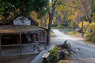
Main Street in Columbia, California | |
 Location in Tuolumne County and the state of California | |
 Columbia Location in the United States | |
| Coordinates: 38°2′2″N 120°24′4″W / 38.03389°N 120.40111°WCoordinates: 38°2′2″N 120°24′4″W / 38.03389°N 120.40111°W | |
| Country |
|
| State |
|
| County | Tuolumne |
| Area[1] | |
| • Total | 5.979 sq mi (15.487 km2) |
| • Land | 5.961 sq mi (15.440 km2) |
| • Water | 0.018 sq mi (0.047 km2) 0.31% |
| Elevation[2] | 2,139 ft (652 m) |
| Population (2010) | |
| • Total | 2,297 |
| • Density | 380/sq mi (150/km2) |
| Time zone | Pacific (PST) (UTC-8) |
| • Summer (DST) | PDT (UTC-7) |
| ZIP code | 95310 |
| Area code | 209 |
| FIPS code | 06-14904 |
| GNIS feature IDs | 277490, 2407648 |
| Reference no. | 123[3] |

Columbia is a town located in the Sierra Nevada foothills, in Tuolumne County, California, United States. It was founded as a boomtown in 1850 when gold was found in the vicinity, and was known as the "Gem of the Southern Mines."
The town's historic central district is within the Columbia State Historic Park, which preserves the 19th century mining town features. The U.S. historic district is a National Historic Landmark and on the National Register of Historic Places
Geography
Columbia is located along State Route 49 just north of Sonora, at an altitude of 2,139 feet (652 m). Wired telephones in Columbia work out of the Sonora central office.
According to the United States Census Bureau, the CDP has a total area of 6.0 square miles (16 km2). Only 0.31% of the total area is covered by water.
Climate
This region experiences hot and dry summers, with no average monthly temperatures above 90.1 °F. According to the Köppen Climate Classification system, Columbia has a warm-summer Mediterranean climate, abbreviated "Csb" on climate maps.[4]
History

The original indigenous people in the Columbia region were of the Miwok.
Rev. John Steele wrote about his time in the gold rush era and about the "Mi-wuk" of Columbia in his memoirs In Camp and Cabin.
Within weeks of finding gold in the vicinity of Columbia, thousands of people arrived and the population climbed to 5,000. By 1852, there were 8 hotels, 4 banks, 17 general stores, 2 firehouses, 2 bookstores, 1 newspaper, 3 churches, and over 40 drinking/gambling establishments. Between 1850 and the early 1900s, $150 million in gold was removed from the surrounding hills.
In 1851, the local community brass band, a popular institution, greeted the arrival of the first "white woman" in town.[5] Columbia had five cemeteries, including a Boot Hill, where burials were made without markers.[6]
In 1854, Columbia's first fire destroyed 6 city blocks. The town was rebuilt using brick with iron construction materials. In 1857, another fire burned down nearly everything else, except the brick buildings. The Columbia one-room school house was built in 1860, renovated in 1872, and finally closed in 1937. It was purchased by the state of California for $1 in 1947, and incorporated into the historic district park.
By 1860, the gold mined in Columbia was diminishing rapidly. The only land left to mine was in the city itself. Miners dug under buildings and tore down houses to get at the gold beneath the city. Copper deposits were found in the area, with the nearby town of Copperopolis experiencing a boom. The bricks from the destroyed buildings in Columbia were sold for new construction in Copperopolis.
Columbia, in its heyday, was California's second-largest city although only about 2,000 people now live in this region. It was even considered briefly as a site for the state capitol of California. Unlike many gold rush boomtowns, Columbia never became a ghost town. In 1945, California created Columbia State Historic Park from the remains of the historical buildings of the city.
Visitor attractions
Columbia's main street in the historic district, part of the Columbia State Historic Park, is closed to automobile traffic, but horses, carriages, bicycles and pedestrians are welcomed. Known for the huge rock gardens left over from the hydro mining efforts in the 1800s, the area is very popular with families for picnicking and leisurely walks. The antique buildings are leased to era-themed businesses such as gold-panning, candle-dipping, iron-mongering, and crafts. There are several eating establishments, including the Fallon House Ice Cream Parlor and the Candy Store. A chicken coop with beautiful Barred-Rock hens lends a sweet background sound to Main Street. A horse-drawn wagon ride for a fee is the main attraction. There are numerous events throughout the year; some of the notable occasions are the Fourth of July parade and Pioneer Days. Occasionally local crafters set up booths along Main Street. Costumed State Park employees and shopkeepers lend to the era-theme of the park. Picnic tables are situated throughout the downtown. There is a fairly long hiking trail from the School House, which is located a couple of blocks from the town. The school is open with static exhibits. Two campgrounds nearby accommodate tenting and motorhomes, as well as a small general store for supplies. Two well-stocked thrift stores are within walking distance; one, Nancy's Hope Thrift Store, is located behind the 49er Church and supports local families.
Other points of interest in the area include Columbia Community College, a two-year, community college; and the Columbia Airport (FAA designator: O22), which has one 4,670-foot (1,420 m) runway and is busy with firefighting aircraft during summer.
The annual Columbia Fire Muster here is often the earliest of California's summer musters.
Demographics


2010
The 2010 United States Census[7] reported that Columbia had a population of 2,297. The population density was 384.1 people per square mile (148.3/km²). The racial makeup of Columbia was 2,064 (89.9%) White, 27 (1.2%) African American, 26 (1.1%) Native American, 29 (1.3%) Asian, 1 (0.0%) Pacific Islander, 27 (1.2%) from other races, and 123 (5.4%) from two or more races. Hispanic or Latino of any race were 171 persons (7.4%).
The Census reported that 2,226 people (96.9% of the population) lived in households, 71 (3.1%) lived in non-institutionalized group quarters, and 0 (0%) were institutionalized.
There were 1,002 households, out of which 243 (24.3%) had children under the age of 18 living in them, 432 (43.1%) were opposite-sex married couples living together, 125 (12.5%) had a female householder with no husband present, 51 (5.1%) had a male householder with no wife present. There were 53 (5.3%) unmarried opposite-sex partnerships, and 4 (0.4%) same-sex married couples or partnerships. 330 households (32.9%) were made up of individuals and 142 (14.2%) had someone living alone who was 65 years of age or older. The average household size was 2.22. There were 608 families (60.7% of all households); the average family size was 2.80.
The population was spread out with 470 people (20.5%) under the age of 18, 201 people (8.8%) aged 18 to 24, 406 people (17.7%) aged 25 to 44, 735 people (32.0%) aged 45 to 64, and 485 people (21.1%) who were 65 years of age or older. The median age was 47.8 years. For every 100 females there were 97.3 males. For every 100 females age 18 and over, there were 92.9 males.
There were 1,117 housing units at an average density of 186.8 per square mile (72.1/km²), of which 661 (66.0%) were owner-occupied, and 341 (34.0%) were occupied by renters. The homeowner vacancy rate was 2.1%; the rental vacancy rate was 8.1%. 1,389 people (60.5% of the population) lived in owner-occupied housing units and 837 people (36.4%) lived in rental housing units.
2000
As of the census[8] of 2000, there were 2,405 people, 1,063 households, and 659 families residing in the CDP. The population density was 389.7 people per square mile (150.5/km²). There were 1,162 housing units at an average density of 188.3 per square mile (72.7/km²). The racial makeup of the CDP was 90.10% White, 0.87% African American, 1.41% Native American, 1.29% Asian, 0.12% Pacific Islander, 1.29% from other races, and 4.91% from two or more races. Hispanic or Latino of any race were 6.90% of the population.
There were 1,063 households out of which 22.6% had children under the age of 18 living with them, 44.3% were married couples living together, 13.0% had a female householder with no husband present, and 38.0% were non-families. 29.7% of all households were made up of individuals and 14.3% had someone living alone who was 65 years of age or older. The average household size was 2.18 and the average family size was 2.65.
In the CDP the population was spread out with 20.2% under the age of 18, 10.0% from 18 to 24, 18.8% from 25 to 44, 28.1% from 45 to 64, and 22.9% who were 65 years of age or older. The median age was 46 years. For every 100 females there were 89.1 males. For every 100 females age 18 and over, there were 88.4 males.
The median income for a household in the CDP was $29,173, and the median income for a family was $35,000. Males had a median income of $40,729 versus $23,750 for females. The per capita income for the CDP was $18,731. About 20.2% of families and 19.0% of the population were below the poverty line, including 37.7% of those under age 18 and 1.4% of those age 65 or over.
Notable people
- Delmer Berg, United States World War II veteran and Spanish Civil War veteran, lived in Columbia.[9]
- Red Kress, Major League Baseball player and coach, was born in Columbia.[10]
- Peter Muldoon, Roman Catholic Bishop of the Diocese of Rockford, was born in Columbia.[11]
Filming location
A few of the more than 100 movies and TV series filmed in Columbia include:
- Sierra Spirits, 2007
- Behind the Mask of Zorro, 2005
- Radio Flyer, 1992
- Blood Red, 1989
- Pale Rider, 1985
- The Shadow Riders, 1982
- Joe Dancer: The Big Trade, 1981
- The Last Ride of the Dalton Gang, 1979
- Law of the Land, 1976
- Little House on the Prairie, 1974
- Something for a Lonely Man, 1968
- Rage at Dawn, 1955
- Texas Lady, 1955
- The Cimarron Kid, 1952
- Death Valley Days, 1952
- High Noon, 1952
- The Lone Ranger, 1949
- Rustlers' Valley, 1937
- Wells Fargo, 1937
- The Best Bad Man, 1925
- Timber Stampede, 1939
Government
In the California State Legislature, Columbia is in the 8th Senate District, represented by Republican Tom Berryhill, and in the 5th Assembly District, represented by Republican Frank Bigelow.[12]
In the United States House of Representatives, Columbia is in California's 4th congressional district, represented by Republican Tom McClintock.[13]
Notes
- ↑ "2010 Census Gazetteer Files - Places - California". United States Census Bureau. Retrieved March 26, 2015.
- ↑ "Columbia". Geographic Names Information System. United States Geological Survey. Retrieved November 4, 2014.
- ↑ "Columbia". Office of Historic Preservation, California State Parks. Retrieved 2012-10-18.
- ↑ Climate Summary for Columbia, California
- ↑ Abel, pg. 133
- ↑ Hoover, pg. 223
- ↑ "2010 Census Interactive Population Search: CA - Columbia CDP". U.S. Census Bureau. Retrieved July 12, 2014.
- ↑ "American FactFinder". United States Census Bureau. Archived from the original on September 11, 2013. Retrieved 2008-01-31.
- ↑ The Voluteer: California Vets; Del Berg and Jim Benet
- ↑ Baseball Reference.com.-Red Kress
- ↑ Peter James Muldoon
- ↑ "Statewide Database". UC Regents. Retrieved November 23, 2014.
- ↑ "California's 4th Congressional District - Representatives & District Map". Civic Impulse, LLC. Retrieved September 28, 2014.
References
- Abel, E. Lawrence (2000). Singing the New Nation: How Music Shaped the Confederacy, 1861-1865. Mechanicsburg, Pennsylvania: Stackpole Books. ISBN 0-8117-0228-6.
- Hoover, Mildred B.; Douglas E. Kyle (2002). Historic Spots in California. Stanford University Press. ISBN 978-0-8047-4482-9.
External links
| Wikimedia Commons has media related to Columbia, California. |
| Wikimedia Commons has media related to Columbia State Historic Park. |
- Columbia Visitor Guide
- Columbia State Historic Park
- Photographic Tour of the Bell Marble Quarry, Columbia, CA, on Stone Quarries and Beyond.
- Photographic Tour of One of the Historic Columbia Marble Quarries, Columbia, CA, on Stone Quarries and Beyond.
- myMotherLode.com Community Guide
Municipalities and communities of Tuolumne County, California, United States | ||
|---|---|---|
| City | 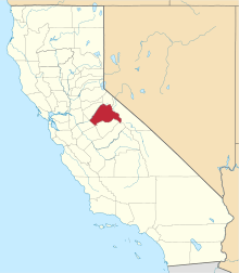 | |
| CDPs | ||
| Unincorporated communities | ||
| Ghost towns |
| |