Climate of Europe
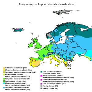
For the most part Europe lies in the northern temperate climate zone. Much of far western Europe is classified as a Temperate Oceanic climate, while far southern Europe is a Mediterranean climate in the south. The climate is strongly conditioned by the Gulf Stream, which keeps mild air (for the latitude) over Northwestern Europe in the winter months, especially in Ireland, the UK and coastal Norway. While Western Europe has an oceanic climate, Eastern Europe has a drier, continental climate. Parts of the Central European plains have a hybrid oceanic/continental climate. Four seasons occur in Eastern Europe, while southern Europe experiences distinct wet season and dry seasons, with prevailing hot and dry conditions during the summer months. The heaviest precipitation occurs downwind of water bodies due to the prevailing westerlies, with higher amounts also seen in the Alps. Tornadoes occur within Europe, with most but not all occurrences being weak.
Overview

Prevailing westerlies generally create much of the prevailing weather across much of Europe. The Siberian High brings colder, drier weather from the east. Away from the sea, parts of Central and Eastern Europe have a borderline Oceanic/Continental Climate as they are milder than they would otherwise be due to the open ice-free waters of the North/Baltic Seas and lack of mountain barriers, but are not as mild as the Western coasts, and are subject to more frequent snowfalls. The Danube region through the Balkans, Ukraine and Southern Russia have a continental climate with cold winters and hotter summers, some areas bordering on a dry steppe climate with only certain months of higher precipitation, often due to thunderstorms. Some coastal regions of the Black Sea have micro-climates that are borderline humid continental/humid subtropical (or sometimes just the latter) due to the winters being mild enough and summer precipitation being high enough to preclude them as being Mediterranean, for example in Sochi, Russia. On the plains of Northern European Russia up to the Ural Mountains, the winter climate is much harsher than elsewhere in Europe with many months of below freezing average temperatures but with periods of hot summer weather. Nevertheless, year-to-year variations can produce different climates such as temperate in the winter, and tropical in the summer.
Gulf Stream


The climate of Western Europe is milder in comparison to other areas of the same latitude around the globe due to the influence of the Gulf Stream. The Mediterranean’s waters are not as deep as the large oceans, allowing it to become a heat store tempering winters along its coastlines.[1] The Gulf Stream is nicknamed "Europe's central heating", because it makes Europe's climate warmer and wetter than it would otherwise be. The North Atlantic Oscillation and Arctic Oscillation also play large roles in determining the amount of Arctic air that penetrates southward diminishing the Gulf stream’s warming effects during winter.[2]
Compared to other parts of the globe, the average temperature throughout the year in Naples is 16 °C (60.8 °F), while it is 13 °C (55.8 °F) in New York City, virtually the same latitude. Berlin, Germany; Calgary, Canada; and Irkutsk, in the Asian part of Russia, lie on around the same latitude; January temperatures in Berlin average around 8 °C (15 °F) higher than those in Calgary (although Calgary sits 1200m higher in altitude), and they are almost 22 °C (40 °F) higher than average temperatures in Irkutsk.[1] This difference is even larger on the northern part of the continent; the January average in Brønnøysund, Norway,[3] is almost 15 °C warmer than the January average in Nome, Alaska,[4] both towns are situated upwind on the west coast of the continents at 65°N, and as much as 42 °C warmer than the January average in Yakutsk which is actually slightly further south. Further south the oceanic climate of Europe compares thermally to North America, at around 48°N Rennes, France has about an equal average temperature throughout the year to Seattle, Washington, although the latter has drier summers with much wetter winters.[5]
Precipitation

On an annual basis, rainfall across the continent is favoured within the Alps, and from Slovenia southward to the western coast of Greece.[6] Other maxima exist in western Georgia, northwest Spain, most of Ireland, western Great Britain, and western Norway. The maxima along the eastern coasts of water bodies are due to the westerly wind flow which dominates across the continent. A bulk of the precipitation across the Alps falls between March and December. The wet season in lands bordering the Mediterranean Sea lasts from October through March, with November and December typically the wettest months.[6] For example, the monthly rainfall at Athens ranges from 6 mm (July) during their dry season to 71 mm (December) during their wet season.[7] Summer rainfall across the continent evaporates completely into the warm atmosphere, leaving winter precipitation to be the source of groundwater for Europe.[8] Places with significant impact by acid rain across the continent include most of eastern Europe from Poland northward into Scandinavia.[9]
The European Monsoon (more commonly known as the Return of the Westerlies) is the result of a resurgence of westerly winds from the Atlantic, where they become loaded with wind and rain. Rather than a traditional monsoon, where warm seas fuel precipitation and storms, they are more cyclonic low-pressure systems that travel along the section of the gulfstream[10] These Westerly winds are a common phenomenon during the European winter, but they ease as Spring approaches in late March and through April and May. The winds pick up again in June, which is why this phenomenon is also known as "the return of the westerlies".[11]
The rain usually arrives in two waves, at the beginning of June and again in mid to late June. These storms generally feature significantly lower than average temperatures, fierce rain or hail, thunder and strong winds.[12] The Return of the Westerlies affects Europe's Northern Atlantic coastline, such as Ireland, Great Britain, the Benelux countries, Western Germany, Northern France and parts of Scandinavia.
There are cycles seen within the rainfall data from Northern Europe between Great Britain and Germany, which are seen at 16 years. Southern Europe experiences a 22-year cycle in rainfall variation. Other smaller term cycles are seen at 10-12 year and 6-7 year periods within the rainfall record.[13] Long term trends suggest rainfall within Greece has been decreasing since 1981.[14]
Rainfall averages between 36 mm (March)to 54 mm (November) in London and from 36 mm (March) to 88 mm (July) in Moscow.[15][16][17]
Temperature
Among the cities with a population over 100,000 people in Europe, the mildest winters in the continent are in southern and eastern Spanish cities - Almeria, Algeciras, Alicante, Cadiz, Cartagena, Jerez de la Frontera, Málaga, Seville and Valencia with 16–18 °C (61–64 °F) during the day in January. Among the capitals of Europe, the mildest winters occur in Valletta, Malta with 15–16 °C (59–61 °F) during the day. The hottest summers of the continent occur in cities and towns of the hinterland of southern Spain: July average highs in this region are 36.2 °C (97.2 °F) in Seville and 36.4 °C (97.5 °F) in Cordoba.
| Jan | Feb | Mar | Apr | May | Jun | Jul | Aug | Sep | Oct | Nov | Dec | Year | |
|---|---|---|---|---|---|---|---|---|---|---|---|---|---|
| Helsinki[17] | -1.3 | -1.9 | 1.6 | 7.6 | 14.4 | 18.5 | 21.5 | 19.8 | 14.6 | 9.0 | 3.7 | 0.5 | 9.0 |
| Minsk[18] | -2.1 | -1.4 | 3.8 | 12.2 | 18.7 | 21.5 | 23.6 | 22.8 | 16.7 | 10.2 | 2.9 | -1.2 | 10.8 |
| Budapest[19] | 1.2 | 4.5 | 10.2 | 16.3 | 21.4 | 24.4 | 26.5 | 26.0 | 22.1 | 16.1 | 8.1 | 3.1 | 15.0 |
| London[20] | 8.1 | 8.6 | 11.6 | 14.6 | 18.1 | 21.0 | 23.4 | 23.1 | 20.0 | 15.5 | 11.3 | 8.4 | 15.3 |
| Paris[21] | 6.9 | 8.2 | 11.8 | 14.7 | 19.0 | 21.8 | 24.4 | 24.6 | 20.8 | 15.8 | 10.4 | 7.8 | 15.5 |
| Bucharest[22] | 1.5 | 4.1 | 10.2 | 18.0 | 23.3 | 26.8 | 28.8 | 28.5 | 24.6 | 18.0 | 10.0 | 3.8 | 16.5 |
| Barcelona[23][24] | 13.4 | 14.6 | 15.9 | 17.6 | 20.5 | 24.2 | 27.5 | 28.7 | 25.5 | 21.5 | 17.0 | 14.3 | 20.0 |
| Rome[25] | 11.9 | 13.0 | 15.2 | 17.7 | 22.8 | 26.9 | 30.5 | 30.6 | 26.5 | 21.4 | 15.9 | 12.6 | 20.4 |
| Lisbon[26] | 14.8 | 16.2 | 18.8 | 19.8 | 22.1 | 25.7 | 27.9 | 28.3 | 26.5 | 22.5 | 18.2 | 15.3 | 21.5 |
| Athens[27] | 12.9 | 13.6 | 16.0 | 20.3 | 25.1 | 29.8 | 32.6 | 32.3 | 28.9 | 23.1 | 18.6 | 14.7 | 22.3 |
| Valencia[28] | 16.1 | 17.2 | 18.7 | 20.2 | 22.8 | 26.2 | 29.1 | 29.6 | 27.6 | 23.6 | 19.5 | 16.8 | 22.3 |
| Malta[29] | 16.1 | 16.0 | 17.8 | 20.0 | 24.2 | 28.5 | 31.5 | 31.8 | 28.4 | 25.2 | 21.0 | 17.5 | 23.2 |
| Jan | Feb | Mar | Apr | May | Jun | Jul | Aug | Sep | Oct | Nov | Dec | |
|---|---|---|---|---|---|---|---|---|---|---|---|---|
| Gdańsk | 4 | 3 | 3 | 4 | 8 | 13 | 16 | 18 | 15 | 12 | 9 | 6 |
| Brighton | 9 | 8 | 8 | 9 | 11 | 13 | 15 | 17 | 17 | 16 | 13 | 11 |
| Marseille | 13 | 13 | 13 | 14 | 16 | 18 | 21 | 22 | 21 | 18 | 16 | 14 |
| Barcelona | 13 | 13 | 13 | 14 | 17 | 20 | 23 | 25 | 23 | 20 | 17 | 15 |
| Rome | 14 | 13 | 13 | 14 | 17 | 21 | 23 | 24 | 23 | 20 | 18 | 15 |
| Valencia | 14 | 13 | 14 | 15 | 17 | 21 | 24 | 26 | 24 | 21 | 18 | 15 |
| Naples | 15 | 14 | 14 | 15 | 18 | 22 | 25 | 27 | 25 | 22 | 19 | 16 |
| Athens | 16 | 15 | 15 | 16 | 18 | 21 | 24 | 24 | 24 | 21 | 19 | 17 |
| Lisbon | 15 | 15 | 15 | 16 | 17 | 18 | 19 | 20 | 20 | 19 | 18 | 17 |
| Málaga | 16 | 15 | 15 | 16 | 17 | 20 | 22 | 23 | 22 | 20 | 18 | 16 |
| Malta | 16 | 16 | 15 | 16 | 18 | 21 | 24 | 26 | 25 | 23 | 21 | 18 |
Tornadoes
The Netherlands has the highest average number of recorded tornadoes per area of any country (more than 20, or 0.0013 per sq mi (0.00048 per km2), annually), followed by the UK (around 33, or 0.00035 per sq mi (0.00013 per km2), per year),[30][31] but most are small and cause minor damage. In absolute number of events, ignoring area, the UK experiences more tornadoes than any other European country, excluding waterspouts.[32] Europe uses its own tornado scale, known as the TORRO scale, which ranges from a T0 for extremely weak tornadoes to T11 for the most powerful known tornadoes.[33]
See also
References
- 1 2 "European Climate". World Book. World Book, Inc. Retrieved 2011-02-15.
- ↑ Seager, Richard (July–August 2006). "The Source of Europe's Mild Climate". American Scientist Online. Retrieved 2008-09-23.
- ↑ Brønnøysund
- ↑ Nome
- ↑ Yakutsk
- 1 2 A. V. Mehta and S. Yang (2008-12-22). "Precipitation climatology over Mediterranean Basin from ten years of TRMM measurements" (PDF). Advances in Geosciences. Copernicus Publications. 17: 87–91. Bibcode:2008AdG....17...87M. Retrieved 2010-01-09.
- ↑ Athens, Greece(retrieved 9 January 2010)
- ↑ Richard Thornsen (1990). "Effect of Climate Variability and Change in Groundwater in Europe" (PDF). Nordic Hydrology. 21: 187. Retrieved 2010-01-10.
- ↑ Ed. Hatier (1993). "Acid Rain in Europe". United Nations Environment Programme GRID Arendal. Retrieved 2010-01-31.
- ↑ Visser, S.W. (1953). Some remarks on the European monsoon. Birkhäuser: Basel.
- ↑ Leo Hickman (2008-07-09). "The Question: What is the European monsoon?". The Guardian. Retrieved 2009-06-09.
- ↑ Paul Simons (2009-06-07). "'European Monsoon' to blame for cold and rainy start to June". The Times. Retrieved 2009-06-09.
- ↑ R. G. Vines (1985-03-25). "European Rainfall Patterns". International Journal of Climatology. 5 (6): 607–616. Bibcode:1985IJCli...5..607V. doi:10.1002/joc.3370050603. Retrieved 2010-01-09.
- ↑ J. D. Pnevmatikos and B. D. Katsoulis (2006-05-31). "The changing rainfall regime in Greece and its impact on climatological means". Meteorological Applications. Cambridge University Press. 13 (4): 331–345. Bibcode:2006MeApp..13..331P. doi:10.1017/S1350482706002350.
- ↑ Average conditions: London, United Kingdom(retrieved 9 January 2010)
- ↑ Average conditions: Moscow, Russian Federation(retrieved 9 january 2010)
- 1 2 Helsinki
- ↑ "Pogoda.ru.net" (in Russian). Retrieved 8 September 2007.
- ↑ http://met.hu/
- ↑ http://www.metoffice.gov.uk/public/weather/climate/gcpuzu47t
- ↑ http://france.meteofrance.com/france/climat_france?CLIMAT_PORTLET.path=climatstationn%2F75114001
- ↑ "Bucuresti Baneasa Climate Normals 1961-1990". www.NOAA.gov. Retrieved 31 October 2012.
- ↑ "Weather Information for Barcelona - World Meteorological Organization (United Nations)".
- ↑ "Valores Climatológicos Normales. Barcelona / Aeropuerto - Agencia Estatal de Meteorología".
- ↑ http://clima.meteoam.it/AtlanteClimatico/pdf/%28239%29Roma%20Ciampino.pdf
- ↑ "Monthly Averages for Lisbon, Portugal". Instituto de Meteorologia. Retrieved 2012-06-16.
- ↑ http://www.yr.no/place/Greece/Attica/Athens/statistics.html
- ↑ "Valores climatológicos normales. Valencia - Agencia Estatal de Meteorología".
- ↑ "Archived copy". Archived from the original on 2015-08-06. Retrieved 2016-09-02.
- ↑ J Holden, A Wright (2003-03-13). "UK tornado climatology and the development of simple prediction tools" (PDF). Quarterly Journal of the Meteorological Society. Royal Meteorological Society. 130: 1009–1021. Bibcode:2004QJRMS.130.1009H. doi:10.1256/qj.03.45. Archived from the original (PDF) on 2007-08-24. Retrieved 2009-12-13.
- ↑ Staff (2002-03-28). "Natural Disasters: Tornadoes". BBC Science and Nature. BBC. Archived from the original on 2002-10-14. Retrieved 2009-12-13.
- ↑ Nikolai Dotzek (2003-03-20). "An updated estimate of tornado occurrence in Europe" (PDF). Atmospheric Research. Retrieved 2009-12-13.
- ↑ Meaden, Terrance (2004). "Wind Scales: Beaufort, T — Scale, and Fujita's Scale". Tornado and Storm Research Organisation. Retrieved 2009-09-11.
