Cheltenham, South Australia
| Cheltenham Adelaide, South Australia | |||||||||||||
|---|---|---|---|---|---|---|---|---|---|---|---|---|---|
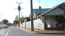 Street in Cheltenham | |||||||||||||
| Population |
2,175 (2006 Census)[1] 2,043 (2001 Census)[2] | ||||||||||||
| Established | 1849[3] | ||||||||||||
| Postcode(s) | 5014[4] | ||||||||||||
| Location | 9.2 km (6 mi) NW of Adelaide city centre[4] | ||||||||||||
| LGA(s) | City of Charles Sturt[5] | ||||||||||||
| State electorate(s) | Cheltenham (2011)[6] | ||||||||||||
| Federal Division(s) | Adelaide (2011)[7] | ||||||||||||
| |||||||||||||

Cheltenham is a suburb of Adelaide, South Australia. It is located in the City of Charles Sturt.
Geography
The suburb lies between Port Road and Cheltenham Parade, which form its southwest and eastern boundaries respectively. The suburb is split in two by the Outer Harbor railway line.[8]
History
Cheltenham Post Office opened on 8 February 1897 and closed in 1910.[9]
Demographics
The 2006 Census by the Australian Bureau of Statistics counted 2,175 persons in Cheltenham on census night. Of these, 50.4% were male and 49.6% were female.[1]
The majority of residents (77.1%) are of Australian birth, with other common census responses being England (4.8%) and Italy (2.5%).[1]
The age distribution of Cheltenham residents is similar to that of the greater Australian population. 68.5% of residents were over 25 years in 2006, compared to the Australian average of 66.5%; and 31.5% were younger than 25 years, compared to the Australian average of 33.5%.[1]
Politics
Local government
Cheltenham is part of Woodville Ward in the City of Charles Sturt local government area, being represented in that council by Oanh Nguyen and Robert Grant.[5]
State and federal
Cheltenham lies in the state electoral district of Cheltenham[6] and the federal electoral division of Port Adelaide.[7] The suburb is represented in the South Australian House of Assembly by Jay Weatherill[6] and federally by Mark Butler.[7]
Facilities and attractions
Cheltenham Cemetery
Cheltenham Cemetery, located between Port Road and Cheltenham Parade,[8] was established in 1876.
Transportation
Roads
Cheltenham is serviced by Port Road, connecting the suburb to Port Adelaide and Adelaide city centre, and by Cheltenham Parade.[8]
Public transport
Cheltenham is serviced by public transport run by the Adelaide Metro.[10]
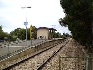
Trains
The Outer Harbor train service passes through the suburb. The closest stations are Cheltenham and Cheltenham Racecourse.[10]
Buses
The suburb is serviced by bus routes run by the Adelaide Metro.[10]
See also
| Wikimedia Commons has media related to Cheltenham, South Australia. |
References
- 1 2 3 4 Australian Bureau of Statistics (25 October 2007). "Cheltenham (State Suburb)". 2006 Census QuickStats. Retrieved 4 June 2011.
- ↑ Australian Bureau of Statistics (9 March 2006). "Cheltenham (State Suburb)". 2001 Census QuickStats. Retrieved 4 June 2011.
- ↑ "Place Names of South Australia". The Manning Index of South Australian History. State Library of South Australia. Retrieved 4 June 2011.
- 1 2 "Cheltenham, South Australia (Adelaide)". Postcodes-Australia. Postcodes-Australia.com. Retrieved 4 June 2011.
- 1 2 "City of Charles Sturt Wards and Council Members" (PDF). City of Charles Sturt. Archived from the original (PDF) on 5 August 2011. Retrieved 4 June 2011.
- 1 2 3 "Electoral Districts - Electoral District for the 2010 Election". Electoral Commission SA. Archived from the original on 22 August 2011. Retrieved 4 June 2011.
- 1 2 3 "Find my electorate: Port Adelaide". Australian Electoral Commission. Retrieved 4 June 2011.
- 1 2 3 Adelaide and surrounds street directory (47th ed.). UBD. 2009. ISBN 978-0-7319-2336-6.
- ↑ Premier Postal History. "Post Office List". Premier Postal Auctions. Retrieved 26 May 2011.
- 1 2 3 "Public Transport in Adelaide". Adelaide Metro official website. Dept. for Transport, Energy and Infrastructure, Public Transport Division. Archived from the original on 26 April 2011. Retrieved 4 June 2011.
External links
- "City of Charles Sturt". Official website. City of Charles Sturt. Retrieved 4 June 2011.
Coordinates: 34°52′08″S 138°31′34″E / 34.869°S 138.526°E