Chan Chan
From top: Chan chan view, capital of Chimor, Chan Chan walls, Adobe detail at Chan Chan, Panel of warriors detail of wall , Pelican in chan chan, Chan Chan Model, a wall in Chan Chan | ||||||||||||
 Shown within Peru | ||||||||||||
| Location | La Libertad Region, Peru | |||||||||||
|---|---|---|---|---|---|---|---|---|---|---|---|---|
| Coordinates | 8°6′21″S 79°4′28″W / 8.10583°S 79.07444°WCoordinates: 8°6′21″S 79°4′28″W / 8.10583°S 79.07444°W | |||||||||||
| History | ||||||||||||
| Founded | 850 | |||||||||||
| Cultures | Chimú culture | |||||||||||
| Official name | Chan Chan Archaeological Zone | |||||||||||
| Type | Cultural | |||||||||||
| Criteria | i, iii | |||||||||||
| Designated | 1986 (10th session) | |||||||||||
| Reference no. | 366 | |||||||||||
| Region | Latin America and the Caribbean | |||||||||||
| Endangered | 1986–present | |||||||||||


Chan Chan, the largest city of the pre-Columbian era in South America,[1] is now an archaeological site in La Libertad Region 5 kilometres (3.1 mi) west of Trujillo, Peru.[2]
Chan Chan is located in the mouth of the Moche Valley[3] and was the capital of the historical empire of the Chimor from 900 to 1470,[4] when they were defeated and incorporated into the Inca Empire.[5] Chimor, a conquest state,[3] developed from the Chimú culture which established itself along the Peruvian coast around 1400 AD.[6] In the Chimú tongue, Chan Chan means "Sun Sun;" it was named for its sunny climate which is cooled year round by a southerly breeze.[7]
Chan Chan is in a particularly arid section of the coastal desert of northern Peru.[7] Due to the lack of rain in this area, the major source of water for Chan Chan is in the form of rivers carrying surface runoff from the Andes.[4] This runoff allows for control of land and water through irrigation systems.
The city of Chan Chan spanned 20 km² and had a dense urban center of 6 km² which contained extravagant ciudadelas.[3] Ciudadelas were large architectural masterpieces which housed plazas, storerooms, and burial platforms for the royals[8] The splendor of these ciudadelas suggests their association with the royal class.[8] Housing for the lower classes of Chan Chan's hierarchical society are known as small, irregular agglutinated rooms (SIARs).[8] Because the lower classes were often artisans whose role in the empire was to produce crafts, many of these SIARs were used as workshops.[8]
The coordinates chosen at right for the location of Chan Chan were determined using "Figure 1: Archaeological Zone of Chan Chan" from Michael West's article, "Community Settlement Patterns at Chan Chan, Peru".[9] In this figure, it can be seen that Verlarde, Laberinto, and Bandelier form the northern border of Chan Chan while Uhle, Chaiguac, Tschudi, and Rivero form its southern flanks.[9] The location chosen for the coordinates is in the center of these cities and so represents a central location for the ruins of Chan Chan amidst this archaeological zone.

Brief History
Chan Chan is believed to have been constructed around 850 AD by the Chimú.[10] It was the Chimor empire capital city with an estimated population of 40,000-60,000 people.[8]
After the Inca conquered the Chimú around 1470 AD, Chan Chan fell into decline.[8] In 1535 AD, Francisco Pizarro founded the Spanish city of Trujillo which pushed Chan Chan further into the shadows.[8] While no longer a teeming capital city, Chan Chan was still well known for its great riches and was consequently looted by the Spaniards.[8] An indication of the great Chimú wealth is seen in a sixteenth century list of items looted from a burial tomb in Chan Chan; a treasure equivalent to 80,000 pesos of gold was recovered (nearly $5,000,000 US dollars in gold).[8]
In 1969, Michael Moseley and Carol J. Mackey began excavations of Chan Chan; today these excavations continue under the Peruvian Instituto Nacional de Cultura.[10]
Conservation plan
In 1998, The "Master Plan for Conservation and Management of the Chan Chan Archeological Complex" was drawn up by the Freedom National Culture Institute of Peru with contributions from the World Heritage Foundation - WHR, ICCROM, and GCI. The plan was approved by the Peruvian Government.[11]
World Heritage Site
On 28 November 1986, UNESCO designated Chan Chan as a World Heritage Site.[12]
Architecture

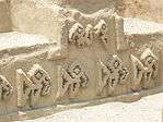
The city has ten walled ciudadelas which housed ceremonial rooms, burial chambers, temples, reservoirs and residences for the Chimú kings.[8] In addition to the ciudadelas, other compounds present in Chan Chan include courts, or audencias[13], small, irregular agglutinated rooms (SIARs) and mounds called huacas.[8] Evidence for the significance of these structures is seen in many funerary ceramics recovered from Chan Chan.[13] Many images seemingly depict structures very similar to audencias[13] which indicates the cultural importance of architecture to the Chimú people of Chan Chan. Additionally, it should be noted that the construction of these massive architectural feats indicates that there was a large labor force available at Chan Chan.[13] This further supports evidence for a hierarchical structure of society in Chan Chan as it was likely that the construction of this architecture was done by the working class.[13]
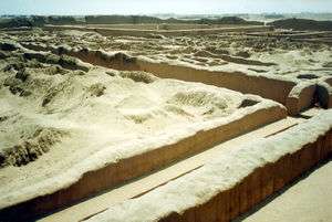
Chan Chan is triangular, surrounded by 50–60-foot (15–18 m) walls.[9] There are no enclosures opening north because the north-facing walls have the greatest sun exposure, serving to block wind and absorb sunlight where fog is frequent.[10] The tallest walls shelter against south-westerly winds from the coast. The walls are adobe brick[8] covered with a smooth surface into which intricate designs are carved. The two styles of carving design include a realistic representation of subjects such as birds, fish, and small mammals, as well as a more graphic, stylized representation of the same subjects. The carvings at Chan Chan depict crabs, turtles, and nets for catching sea creatures (such as Spondylus. Chan Chan, unlike most coastal ruins in Peru, is very close to the Pacific Ocean.[14]
Irrigation

Originally the city relied on wells that were around 15 meters deep.[14] To increase the farmland surrounding the city, a vast network of canals diverting water from the Moche river were created.[15] Once these canals were in place, the city had the potential to grow exponentially. Many canals to the north were destroyed by a catastrophic flood around 1100 CE, which was the key motivation for the Chimú to refocus their economy to one rooted in foreign resources rather than in subsistence farming.[14]
Threats
The ancient structures of Chan Chan are threatened by erosion due to changes in weather patterns — heavy rains, flooding, and strong winds.[16][17] In particular, the city is severely threatened by storms from El Niño, which cause heavy rains and flooding on the Peruvian coast.[7]
See also
- Moche Valley
- Chimú Culture
- Inka empire
- Andes mountains
- Irrigation
- Erosion
- World Heritage Sites in Danger
- Spondylus
- Peru
In-Text Citations
- ↑ Carter, Benjamin (2008-01-01). Technology, Society and Change: Shell Artifact Production Among the Manteno (A.D. 800--1532) of Coastal Ecuador. ProQuest. ISBN 9780549646341.
- ↑ The Smithonian Staff (March 2010), "10 Must-See Endangered Cultural Treasures", Smithsonian, 39 (12): 35 - Chan Chan, Peru, End of an Empire by Bruce Hathaway
- 1 2 3 Moseley, Michael (24 January 1975). "Chan Chan: Andean Alternative of the Preindustrial City". Science. JSTOR 1739056.
- 1 2 Smailes, Richard (March 2011). "Building Chan Chan: A Project Management Perspective". Latin American Antiquity. JSTOR 23072515.
- ↑ Rowe, John (1948). "The Kingdom of Chimor". Acta Americana.
- ↑ D'Altroy, Terence (2002). The Incas. Malden, MA: Blackwell Publishing. p. 41. ISBN 978-0-631-17677-0.
- 1 2 3 Otto Holstein (1927). Chan-Chan: Capital of the Great Chimu. Geographical Review 17 (1, January 1927): 36–61. doi:10.2307/208132 (subscription required)
- 1 2 3 4 5 6 7 8 9 10 11 12 Moore, Jerry (2002). Encyclopedia of Prehistory. Human Relations Area Files, Inc.
- 1 2 3 West, Michael (January 1970). "Community Settlement Patterns at Chan Chan, Peru". American Antiquity. JSTOR 278179.
- 1 2 3 Murray, T (2001). "Chan Chan". Encyclopedia of Archaeology: History and discoveries.
- ↑ "Legal Documentation of the Peruvian Government taking care of Chan Chan" (.PDF).
- ↑ "Chan Chan la ciudadela de barro que resiste al paso del tiempo". Retrieved 2012-11-25.
- 1 2 3 4 5 Keatinge, Richard; Day, Kent (Winter 1973). "Socio-Economic Organization of the Moche Valley, Peru, during the Chimu Occupation of Chan Chan". Journal of Anthropological Research. JSTOR 3629879.
- 1 2 3 The Inca World: The development of pre-Columbian Peru, A.D. 1000-1534 by Laura Laurencich Minelli, Cecilia Bákula, Mireille Vautier – Google Books
- ↑ http://www.greentracks.com/Chan_Chan.htm
- ↑ Endangered Site: Chan Chan, Peru
- ↑ Climate Change: Sites in Peril
References
- Carter, Benjamin. (2008-01-01). Technology, Society and Change: Shell Artifact Production Among the Manteno (A.D. 800--1532) of Coastal Ecuador. ProQuest. ISBN 9780549646341
- D'Altroy, Terence. (2002). The Incas. Malden, MA: Blackwell Publishing. p. 41. ISBN 978-0-631-17677-0.
- Hathaway, Bruce. (March 2010). "10 Must-See Endangered Cultural Treasures: Chan Chan, Peru, End of an Empire." Smithsonian 39 (12): 35.
- Holstein, Otto. (1 January 1927). "Chan-Chan: Capital of the Great Chimu." Geographical Review 17: 36-61. doi: 10.2307/208132.
- Keatinge, Richard W and Day, Kent C. (1973). Socio-Economic Organization of the Moche Valley, Peru, during the Chimu Occupation of Chan Chan. Journal of Anthropological Research 29 (4, Winter 1973): 275–295. doi:10.2307/3629879 (subscription required)
- Kubler, George. (1962). The Art and Architecture of Ancient America, Ringwood: Penguin Books Australia Ltd., pp. 247–274.
- Minelli, Laura Laurencich. 2000. The Inca World: The Development of Pre-Columbian Peru, A.D. 1000-1534, Parts 1000-1534. University of Oklahoma Press.
- Moore, Jerry. (2002). Encyclopedia of Prehistory. Human Relations Area Files, Inc.
- Moseley, Michael. (24 January 1975). "Chan Chan: Andean Alternative of the Preindustrial City." Science 187 (4173).
- Murray, T. (2001). "Chan Chan." Encyclopedia of Archaeology: History and discoveries.
- Rowe, John. (1948). "The Kingdom of Chimor." Acta Americana.
- Smailes, Richard. (2011). Building Chan Chan: a project management perspective. Latin American Antiquity 22 (1, March 2011): 37–63. doi:10.2307/23072515 (subscription required)
- Topic, John R and Moseley Michael. (1983). Chan Chan: a case study of urban change in Peru. Ñawpa Pacha: Journal of Andean Archaeology 21: 153–182. doi:10.2307/3629879 (subscription required)
- West, Michael. (1970). Community Settlement Patterns at Chan Chan, Peru. American Antiquity 35 (1, January 1970): 74–86. doi:10.2307/278179 (subscription required)
External links
| Wikimedia Commons has media related to Chan Chan. |
- UNESCO World Heritage Center: Chan Chan
- Chan Chan information
- Chan Chan - Chimu's Desert City (Flash)
- Heavy Rains Threaten Ancient City in Northern Peru
- Archaeologists Restore High Adobe Walls in Ancient Chimu City of Chan Chan
|  | |