Capon Lake, West Virginia
| Capon Lake | |
|---|---|
| Unincorporated community | |
|
Capon Lake's Historic Whipple Truss | |
 Capon Lake  Capon Lake Location within the state of West Virginia | |
| Coordinates: 39°9′21″N 78°32′16″W / 39.15583°N 78.53778°WCoordinates: 39°9′21″N 78°32′16″W / 39.15583°N 78.53778°W | |
| Country | United States |
| State | West Virginia |
| County | Hampshire |
| Time zone | Eastern (EST) (UTC-5) |
| • Summer (DST) | EDT (UTC-4) |
| GNIS feature ID | 1554067[1] |

Capon Lake is an unincorporated community in Hampshire County of West Virginia's Eastern Panhandle region. Capon Lake is situated between Yellow Spring and Intermont at the junction of West Virginia Route 259 and Capon Springs Road (West Virginia Secondary Route 16) along the Cacapon River. Capon Springs Run empties into the Cacapon here across from the old Capon Lake Whipple Truss Bridge. Capon Lake takes its name from the Cacapon River's lake-like characteristics there. It was a popular picnic spot for tourists and travelers on the Winchester and Western Railroad.
Historic sites
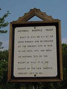
Whipple Truss placard outlining its past.
- Capon Lake Whipple Truss Bridge (1874), along WV Route 259, Listed on the National Register of Historic Places in 2011.
References
External links
![]() Media related to Capon Lake, West Virginia at Wikimedia Commons
Media related to Capon Lake, West Virginia at Wikimedia Commons

This article is issued from Wikipedia - version of the 7/28/2016. The text is available under the Creative Commons Attribution/Share Alike but additional terms may apply for the media files.