Caglesville, Arkansas
| Caglesville, Arkansas | |
|---|---|
| Unincorporated community | |
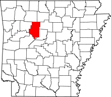
 Caglesville, Arkansas  Caglesville, Arkansas Caglesville's position in Arkansas. | |
| Coordinates: 35°23′43″N 92°57′53″W / 35.39528°N 92.96472°WCoordinates: 35°23′43″N 92°57′53″W / 35.39528°N 92.96472°W | |
| Country |
|
| State |
|
| County | Pope County, Arkansas |
| Elevation | 238 m (781 ft) |
| Time zone | Central (CST) (UTC-6) |
| • Summer (DST) | CDT (UTC-5) |
| GNIS feature ID | 76492 |
Caglesville, Arkansas is an unincorporated community in Center Township, Pope County, Arkansas, United States.[1] The community was named for N. P. Cagle, a local mill operator.[2]
References
- ↑ "Feature Detail Report for: Caglesville, Arkansas." USGS. Profile. Retrieved June 23, 2010.
- ↑ Deane, Ernie (1986). Arkansas Place Names. Branson, Missouri: The Ozarks Mountaineer. p. 139.
This article is issued from Wikipedia - version of the 7/29/2016. The text is available under the Creative Commons Attribution/Share Alike but additional terms may apply for the media files.