Buzzard Roost, Alabama
| Buzzard Roost, Alabama | |
|---|---|
| Unincorporated community | |
 Buzzard Roost, Alabama Location in Alabama. | |
| Coordinates: 34°45′40″N 88°01′26″W / 34.76111°N 88.02389°W | |
| Country | United States |
| State | Alabama |
| County | Colbert |
| Elevation | 466 ft (142 m) |
| Time zone | Central (CST) (UTC-6) |
| • Summer (DST) | CDT (UTC-5) |
| Area code(s) | 256 |
Buzzard Roost is an unincorporated community in Colbert County, Alabama.[1] Buzzard Roost had a post office in the 1850s, but it no longer exists.[2]
Geography
Buzzard Roost is located three miles west of Cherokee on U.S. Route 72.
History
Bernard Romans' Map of 1772 indicated a place called "Chickianooe", which appears to be a misprint of the Choctaw word "Chickianoce," "Skeki anusi" or “anosi,” "meaning Buzzards there sleep."[3]
Levi Colbert, Chickasaw Bench Chief built his stand in Buzzard Roost in 1801, and he ran an inn with his family. An exhibit telling his story is part of the Natchez Trace Parkway.[4][5][6][7] He is credited with changing the name from Buzzard Sleep to Buzzard Roost.[8]
In the 1840s, Armstead Barton built Barton Hall, also known as the Cunningham Plantation, an antebellum plantation house.[9]
Buzzard Roost Covered Bridge, built over Buzzard Roost Creek in 1860, was 94 ft. long, and located on "Allsboro Rd., which is part of the Natchez Trace Parkway System". It was destroyed by fire on July 15, 1972.[10][11][12]
In 1958, a type of spear point dating from the Early to an early Middle Archaic period, the Buzzard Roost Creek Point, was named after a site on Buzzard Roost Creek, by James W. Cambron.[13][14]
Buzzard Roost was added to the National Register of Historic Places November 7, 1976.[15]
As of 2011, a Pratt pony truss bridge built over Buzzard Roost Creek in 1940 remains, although it is rated "structurally deficient."[16]
References
- ↑ U.S. Geological Survey Geographic Names Information System: Buzzard Roost, Alabama
- ↑ U.S. Geological Survey Geographic Names Information System: Buzzard Roost Post Office (historical)
- ↑ "Roman 1772 Map". Mississippi Genealogical and Historical Research. 2001. Retrieved 2013-02-06.
- ↑ Natchez Trace Parkway - Buzzard Roost Spring, near Cherokee, AL
- ↑ Photographs of Buzzard Roost Spring
- ↑ "Levi Colbert b. 1759 Muscle Shoals, Colbert County. Alabama d. 2 JUN 1834 Buzzard Roost Spring, Colbert County. Alabama: Lest Our Past Be Forgotten". Lawrence Stanley Family Genealogy. Retrieved 2013-02-05.
- ↑ "Levi Colbert". Viki's Little Corner of the Web : A Resource for Chickasaw Native American History and Genealogy. Archived from the original on May 9, 2008. Retrieved 2013-02-05.
- ↑ "Buzzard Roost Spring - Natchez Trace". NatchezTraceTravel.com. Retrieved 2013-02-05.
- ↑ Fred Smoot. "Colbert County History / Barton Hall". Retrieved 2007-06-19.
- ↑ Dale Travis (2012-01-13). "Alabama Covered Bridges List". Retrieved 2013-02-05.
- ↑ Interior of Buzzard Roost Covered Bridge, three miles west of Cherokee, Colbert County
- ↑ Buzzard Roost Covered Bridge
- ↑ Lloyd Schroder (2012-07-03). "Buzzard Roost Creek". Peach State Archaeological Society. Retrieved 2013-02-05.
- ↑ "Point type: Buzzard Roost Creek". LITHICS-Net. Retrieved 2013-02-05.
- ↑ "Buzzard Roost". LandmarkHunter.com. Retrieved 2013-02-05.
- ↑ Ben Tate (April 2011). "Buzzard Roost Creek Bridge, Colbert County, Alabama". Bridgehunter.com. Retrieved 2013-02-05.
External links
- Natchez Trace Parkway - Buzzard Roost Spring, near Cherokee, AL
- Historic American Buildings Survey (HABS) No. AL-361-B, "Buzzard Roost Covered Bridge, Highway to Allsboro Southwest of Cherokee, Cherokee, Colbert County, AL", 2 photos
- Photographs of Buzzard Roost Spring
- Buzzard Roost Covered Bridge
- Buzzard Roost Bridge, Bham Wiki
- Riverton Rose Trail Buzzard Roost Creek Bridge
Municipalities and communities of Colbert County, Alabama, United States | ||
|---|---|---|
| Cities | 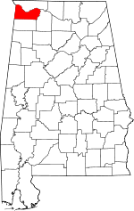 | |
| Towns | ||
| Unincorporated communities | ||