Brühl (Rhineland)
| Brühl | ||
|---|---|---|
|
| ||
| ||
 Brühl | ||
Location of Brühl within Rhein-Erft-Kreis district 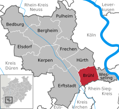
 | ||
| Coordinates: 50°50′N 6°54′E / 50.833°N 6.900°ECoordinates: 50°50′N 6°54′E / 50.833°N 6.900°E | ||
| Country | Germany | |
| State | North Rhine-Westphalia | |
| Admin. region | Köln | |
| District | Rhein-Erft-Kreis | |
| Government | ||
| • Mayor | Dieter Freytag (SPD) | |
| Area | ||
| • Total | 36.12 km2 (13.95 sq mi) | |
| Population (2015-12-31)[1] | ||
| • Total | 44,768 | |
| • Density | 1,200/km2 (3,200/sq mi) | |
| Time zone | CET/CEST (UTC+1/+2) | |
| Postal codes | 50321 | |
| Dialling codes | 02232 | |
| Vehicle registration | BM | |
| Website | www.bruehl.de | |


![]() Brühl is a town in the Rhineland, Germany. It is located in the district Rhein-Erft-Kreis, 20 km south of the Cologne city center and at the edge of the Kottenforst-Ville nature reserve.
Brühl is a town in the Rhineland, Germany. It is located in the district Rhein-Erft-Kreis, 20 km south of the Cologne city center and at the edge of the Kottenforst-Ville nature reserve.
History

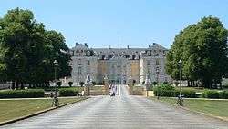
Brühl received its town privileges in 1285. From 1567 on, the city of Brühl was the official residence of the Prince Bishops of Cologne. In the 18th century the Prince Bishop Clemens August replaced a former ruined castle and built the Augustusburg and Falkenlust palaces near the city center. Today both are listed as UNESCO World Heritage Sites. Until 1990 Augustusburg palace was used by the federal government to receive foreign heads of states visiting West Germany.
Main sights
- The amusement park Phantasialand.
- The Max-Ernst-Museum, opened in 2005. It displays sculptures and paintings of the surrealistic artist Max Ernst, who was born in Brühl.
- Local history and pottery are shown in two small museums in the city center.
Infrastructure
Brühl station is on the Left Rhine line and the nearby Kierberg station is on the Eifel Railway. Brühl also has several stops on line 18 of the Cologne Stadtbahn.
Sons and daughters of the city
- Max Ernst (1891-1976), painter and sculptor
- Else Schmitt (1921-1995), politician (SPD) and a & nbsp; a. First district mayor in Cologne
- Josef Engel (1922-1978), historian
- Helmut Müller-Brühl (1933-2012), conductor and initiator of the Brühl Schlosskonzerte at the Augustusburg Palace
- Erika Reihlen (born 1936), theologian and former president of the German Protestant Church Day
- Reiner Calmund (born 1948), football coach and former manager of Bayer 04 Leverkusen
- Hans Leyendecker (born 1949), journalist
- Heinz-Josef Kehr (1950-2014), footballer
- Patric Hemgesberg (born 1973), lyricist
References
- ↑ "Amtliche Bevölkerungszahlen". Landesbetrieb Information und Technik NRW (in German). 18 July 2016.
External links
![]() Media related to Brühl (Rheinland) at Wikimedia Commons
Media related to Brühl (Rheinland) at Wikimedia Commons
| Wikisource has the text of the 1911 Encyclopædia Britannica article Brühl. |
Towns in Rhein-Erft-Kreis | ||
|---|---|---|
