Bowsher Ford Covered Bridge
| Bowsher Ford Covered Bridge | |
| National Register of Historic Places | |
 | |
| Official name: Bowsher Ford Covered Bridge | |
| Named for: Bowsher Ford | |
| Country | |
|---|---|
| State | |
| County | Parke |
| Township | Liberty |
| Road | Bowsher Road |
| Crosses | Mill Creek, Indiana |
| Coordinates | 39°55′47.17″N 87°21′6.38″W / 39.9297694°N 87.3517722°WCoordinates: 39°55′47.17″N 87°21′6.38″W / 39.9297694°N 87.3517722°W |
| Length | 92 ft (28 m) 72ft +10ft overhangs on each end |
| Width | 16 ft (5 m) |
| Clearance | 13.5 ft (4 m) |
| Builder | Britton, Eugene |
| Design | Single Burr Arch truss bridge |
| Material | Wood |
| Built | 1915 |
| Owned and Maintained by | Parke County |
| NBI Number | 6100159[1] |
| WGCB Number | #14-61-33 [2] |
| Added to NRHP | Dec 22, 1978 |
| NRHP Ref# | 78000385 [3] |
| MPS | Parke County Covered Bridges TR |
 Location of the Bowsher Ford Covered Bridge in Indiana
| |
 Location of Indiana in the United States
| |
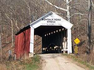
The Bowsher Ford Covered Bridge is a single span Burr Arch truss covered bridge structure that was built by J.A. Britton's son, Eugene Britton, in 1915.[2][4][5]
History
Elmer Garrard won the bid to build this bridge but needed the Britton families expertise. Eugene Britton was contracted and credited as the builder.[2]
It was added to the National Register of Historic Places in 1978.[3]
Gallery
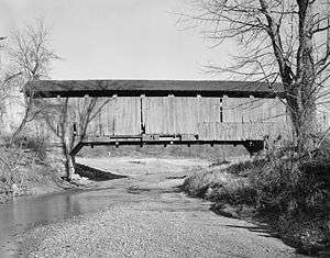
 Bowsher Ford Bridge in the mid-1990s.
See also
- List of Registered Historic Places in Indiana
- Parke County Covered Bridges
- Parke County Covered Bridge Festival
References
- ↑ http://nationalbridges.com/
- 1 2 3 http://www.indianacrossings.org/bridgeLinks/14-61-33.html
- 1 2 National Park Service (2007-01-23). "National Register Information System". National Register of Historic Places. National Park Service.
- ↑ "Bowsher Ford Covered Bridge (#32)". Parke County Incorporated / Parke County Convention and Visitors Commission. Retrieved 20 September 2016.
- ↑ "Indiana State Historic Architectural and Archaeological Research Database (SHAARD)" (Searchable database). Department of Natural Resources, Division of Historic Preservation and Archaeology. Retrieved 2016-06-01. Note: This includes Charles Felkner (December 1977). "National Register of Historic Places Inventory Nomination Form: Parke County Covered Bridge Historic District" (PDF). Retrieved 2016-06-01., Site map, and Accompanying photographs.
External links

This article is issued from Wikipedia - version of the 11/8/2016. The text is available under the Creative Commons Attribution/Share Alike but additional terms may apply for the media files.