Bow Lake (New Hampshire)
| Bow Lake | |
|---|---|
 Bow Lake in autumn as seen from the town dock in Strafford, NH | |
| Location | Strafford County and Rockingham County, New Hampshire |
| Coordinates | 43°14′56″N 71°10′54″W / 43.24889°N 71.18167°WCoordinates: 43°14′56″N 71°10′54″W / 43.24889°N 71.18167°W |
| Primary inflows | Sherburne Brook |
| Primary outflows | Isinglass River |
| Basin countries | United States |
| Max. length | 2.8 mi (4.5 km) |
| Max. width | 1.2 mi (1.9 km) |
| Surface area | 1,149 acres (465 ha) |
| Average depth | 10 ft (3.0 m) |
| Max. depth | 65 ft (20 m) |
| Surface elevation | 515 ft (157 m) |
| Islands |
7 named: Bennett Island; Loon Island; Long Island; Beech Island; Pine Island; Rye Island; York Island |
| Settlements | Strafford (Bow Lake Village); Northwood |
Bow Lake is a 1,149-acre (465 ha)[1] water body located in Strafford and Rockingham counties in eastern New Hampshire, United States, in the towns of Strafford and Northwood. Its outlet is the Isinglass River, flowing east to the Atlantic Ocean via the Cocheco and Piscataqua rivers.
The lake is classified as a cold- and warmwater fishery, with observed species including rainbow trout, brown trout, smallmouth bass, largemouth bass, chain pickerel, horned pout, and white perch.[1]
See also
References
- 1 2 "Bow Lake, Strafford" (PDF). NH Fish & Game. Retrieved August 6, 2014.
-
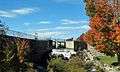
The Bow Lake dam in Strafford. The dam represents the start of the Isinglass River which feeds into the Cochecho River, some 15 miles away.
-
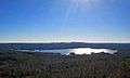
Bow Lake as seen from Parker Mountain in Strafford
This article is issued from Wikipedia - version of the 7/13/2016. The text is available under the Creative Commons Attribution/Share Alike but additional terms may apply for the media files.